Climate Matters
8 in 10 U.S. Coastal Flood Days Are Due to Climate Change
Analysis finds that human-caused sea level rise is driving a surge in coastal flooding across the U.S., putting coastal communities, economies, and ecosystems at risk.
Climate Matters•November 4, 2026•Reuse this content
Heat-trapping pollution, mainly from burning fossil fuels, is warming the planet and causing sea levels to rise mainly due to melting glaciers and ice sheets and the thermal expansion of seawater as it warms.
Mean sea level rose about 9 inches globally during 1901-2025, and nearly 16 inches along U.S. coasts during 1900-2024.
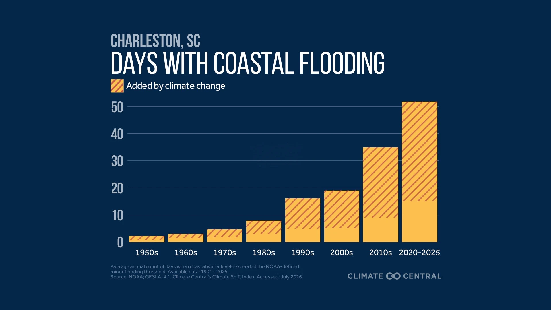
Rising seas cause more frequent coastal flooding. Over the last decade, human-caused sea level rise accounted for about eight in every 10 days with coastal flooding across 71 U.S. locations.
Rising seas also give storm surges a higher starting point, increasing flood damage during coastal storms.
Along U.S. coasts, sea levels are projected to rise an additional 10-12 inches by 2050. Reducing heat-trapping pollution, mainly from burning fossil fuels, can limit future sea level rise and related hazards.
Many coastal communities are adapting to reduce risk and build resilience to accelerating sea level rise.
As heat-trapping pollution warms the planet, sea levels are rising around the globe. Sea level rise isn't just a threat to distant shorelines decades from now; it's already changing what tides and storms can do to coastal communities in the U.S. and around the globe.
Rising sea levels push tidelines higher, causing more coastal floods days that disrupt daily life.
Sea level rise also gives storms a higher starting point, allowing destructive and deadly storm surges to reach farther inland and bring deeper floodwaters that create more extensive damage.
About 30% of the U.S. population lives in marine coastal counties. Sea level rise damages the transportation infrastructure coastal residents rely on daily, while eroding habitats for fish and wildlife.
The effects of sea level rise can extend far beyond the coast. Increasingly frequent, costly disruptions to coastal areas that support the $511 billion U.S. marine economy can affect trade and supply chains nationwide.
These resources explain how heat-trapping pollution drives sea level rise — resulting in more frequent coastal flooding and more damaging storm surges.
Global mean sea level rose about 9 inches from 1901 to 2025 and has accelerated since the late 1960s. Human activities are the primary cause.
Average sea level along the contiguous U.S. coast rose about 15.7 inches from 1900 to 2024, and the rate of rise doubled during that 125-year period. According to NOAA, sea levels along U.S. coasts are expected to rise as much between 2020 and 2050 (10-12 inches, on average) as they did over the last century (1920-2020).
The leading causes of global sea level rise are melting land ice (including glaciers and the Greenland and Antarctic Ice Sheets) and thermal expansion of seawater as it warms. These two factors account for 49% and 43%, respectively, of observed global sea level rise during 1993-2023. Here’s how:
Melting land ice:
As the planet warms, glaciers and the Greenland and Antarctic ice sheets melt and flow off land and into the ocean, contributing to rising sea levels. Meanwhile, warmer oceans thin or break apart floating ice shelves that help hold back land ice.
The contribution from melting land ice has increased since the early 1900s, becoming the dominant driver of global sea level rise this century.
Faster ice loss in the future, especially from Antarctica, could raise seas much higher, increasing the risk of coastal flooding later this century and beyond.
Thermal expansion of seawater:
About 90% of the excess heat trapped on Earth in recent decades due to heat-trapping greenhouse gas pollution has gone into the ocean, which has warmed rapidly as a result.
As oceans heat up, seawater molecules move farther apart, expanding their collective volume and contributing to sea level rise.
Rates of sea level rise vary regionally, but it’s a universal fact that more heat-trapping pollution means more warming, more melting ice, and higher sea levels.
Without reductions in pollution and risk, coastal communities, economies, and ecosystems in the U.S. and around the world will face worsening impacts from sea level rise.
As sea levels rise, high tide lines creep farther inland, regularly flooding areas that previously flooded only during storms or extreme rainfall.
This high tide flooding — also called nuisance flooding or sunny day flooding — is becoming more common in the U.S.
Recent Climate Central analysis found that the frequency of U.S. coastal flooding has more than tripled since the 2000s, and that heat-trapping pollution is already making it worse. Over the last decade (2016-2025), human-caused sea level rise accounted for about eight in every 10 days with coastal flooding across 71 U.S. locations.
Such flooding can overwhelm stormwater systems, flood streets, inundate coastal infrastructure and ecosystems, affect septic systems and freshwater supplies, and disrupt coastal economies by decreasing economic activity and property values.
High tide flooding impacts transportation systems and infrastructure by regularly submerging and closing roads, which gradually degrades the structural integrity of roads. Repeated flooding can cause frequent delays for commuters and interrupt access to medical care and schools.
These impacts worsen during so-called king tides, the highest astronomical tides of the year. Flood risks compound if extreme high tides also overlap with heavy rain or storms.
High tide flooding can be disruptive and costly for coastal communities and the millions who rely on the marine economy for tourism, recreation, and national defense.
These impacts will worsen with continued heat-trapping pollution. By 2050, high tide flooding is expected to occur 10 times as often as it did in 2020.
And by 2060, future sea level rise is projected to cause a 10-fold increase (compared to the 2010s) in the duration of East Coast traffic delays from high tide flooding submerging roads.
Storm surge is the storm-driven rise in water above the normal tide. With higher sea levels, storm surges start from a higher baseline and can reach farther inland and cause more damage.
Storm surge can be life-threatening, accounting for 11% of deaths in the U.S. from tropical cyclones during 2013-2022. It also poses long-term health risks by creating ideal growing conditions for mold and other microbes in water-damaged homes.
A few additional inches of sea level can push floodwaters into electrical systems and building interiors that a shallower flood would have missed, causing more widespread flooding and costly damages.
When Hurricane Sandy hit the East Coast in 2012, it resulted in 71,000 more flood-affected people and $8.1 billion more in damages than would have occurred without human-caused sea level rise, according to Climate Central-led research.
Storm surge, daily tides, and wave action are all layered on top of rising baseline sea levels, increasing total flood levels even when a storm itself is no stronger than one a generation ago.
A 2026 study found that extreme coastal sea level events associated with flooding have grown about 12 times more frequent globally since 1900 — and that human-caused sea level rise alone drove about a fourfold increase, dramatically increasing coastal flood risks.
Ultimately, cutting heat-trapping pollution is the most effective way to slow future warming and limit related hazards such as high tide flooding and storm surge worsened by sea level rise.
Adaptation can also help coastal communities reduce risk and enhance resilience to ongoing sea level rise.
Coastal defenses can help prevent or limit flooding. Traditional coastal defenses like seawalls and breakwaters can help block direct wave action and reduce tidal flooding, though they can also worsen erosion in neighboring stretches of the coast. Natural barriers such as sand dunes, wetlands, and mangroves can also help stabilize shorelines, protect coasts, and provide wildlife habitats.
Recent research suggests that integrating traditional and natural coastal defenses may be more effective, economical, and sustainable than using them separately.
The resilience of existing infrastructure can be bolstered by elevating or floodproofing buildings, upgrading drainage and backflow protection, and adapting transportation systems to handle more frequent flooding.
Coastal communities can also account for future sea level rise when planning new infrastructure through zoning, building codes, engineering, and design.
Explore projected sea level rise, coastal flood risks, and potential adaptation measures along U.S. coastlines with Climate Central’s Coastal Risk Finder.
Climate Central has a suite of relevant tools: Coastal Risk Finder maps local sea level rise and coastal flood projections, assesses who and what is at risk in coastal communities, and explains potential solutions. Climate Shift Index®: Ocean calculates and maps the influence of climate change on sea surface temperatures around the globe, every day. Picturing Our Future visualizes how 190 landmark sites would be affected by coastal flooding under different warming scenarios. Climate Central’s FloodVision® generates science-based visualizations of local flood risk from storm surge and sea level rise.
Use NOAA’s Coastal County Snapshots to explore, visualize, and download data about flood hazards, sea level rise, and the marine and coastal economy in 850+ coastal counties across 37 coastal states and territories. Go deeper with NOAA’s Coastal Flood Exposure Mapper to locate people, infrastructure, and ecosystems exposed to flood hazards along U.S. coasts. NOAA’s Sea Level Calculator shows how sea levels have changed and how coastal flooding is projected to change at local tide stations and other coastal locations. NOAA’s Sea Level Calculator shows how sea levels have changed and how coastal flooding is projected to change at local tide stations and other coastal locations. NOAA’s Coastal Inundation Dashboard provides 48-hour forecasts and local images of recent floods. The National Weather Service provides real time coastal flood watches, warnings, and advisories.
To request an interview with a Climate Central expert about this resource, please contact Abbie Veitch, aveitch@climatecentral.org.
Climate Matters © 2026 by Climate Central is licensed under CC BY 4.0
This license grants permission to use, distribute, and reproduce all text, graphics, and multimedia content published on this page in any medium, provided that Climate Central is credited per the CC BY 4.0 license.
Permission to use data and other materials published on this page is granted for non-commercial uses, commercial news purposes, and educational purposes as governed by Climate Central's Terms of Use.
Loading visual assets...
Loading visual assets...
Loading visual assets...
Loading visual assets...
Loading visual assets...
Loading visual assets...