
Climate Shift Index Alerts
Using our Climate Shift Index (CSI) system (including Ocean CSI and Tropical Cyclone CSI), we issue alerts when select extreme weather events — such as heat waves, hurricanes, or wildfires — are made more likely by human-caused climate change.
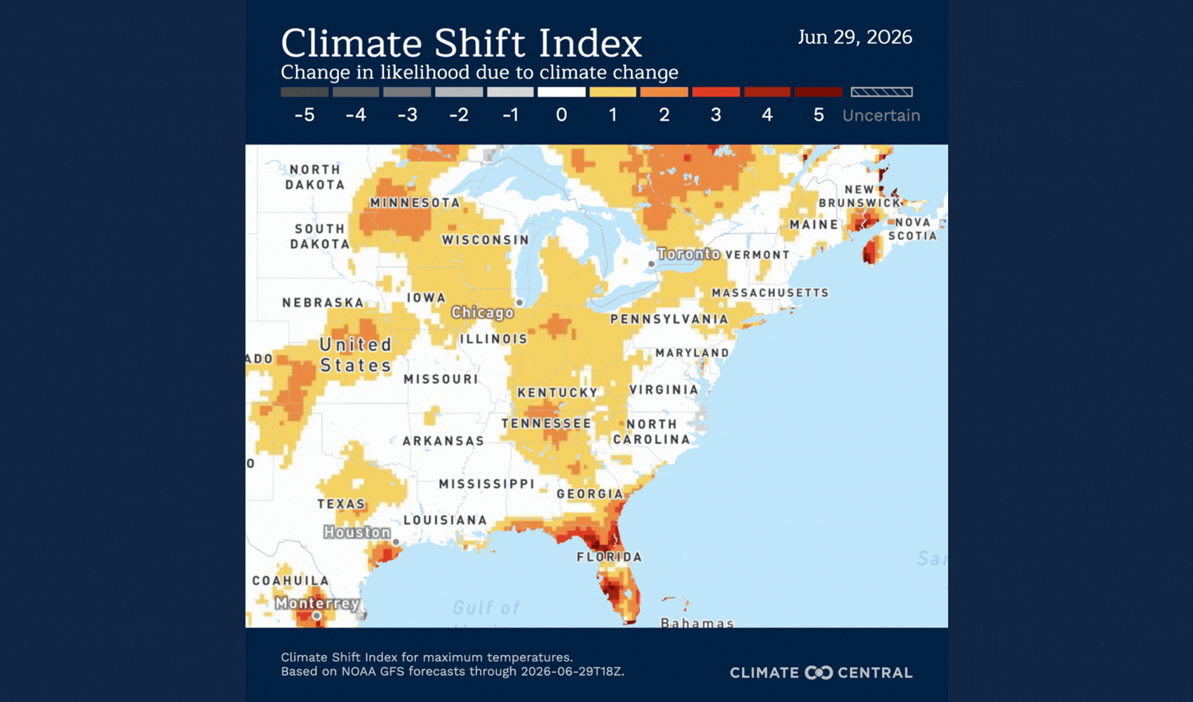
Explore the log below to see a sampling of recent events linked to climate change, and use the CSI and Ocean CSI map tools to investigate daily conditions in your area.
Want to receive these alerts? Join our email list.
Climate change fuels extreme Fourth of July weekend heat wave across the U.S.
A dangerous heat wave will bring prolonged high temperatures, humidity, and warm overnight conditions to much of the eastern United States through the Fourth of July holiday (June 29–July 5). Human-caused climate change has significantly increased the likelihood and the intensity of this event, with the highest Climate Shift Index levels — CSI 5 — forecast across large parts of the country.
How unusual is the forecasted heat?
A significant heat wave, primarily impacting the eastern half of the United States, is the result of a strong, slow-moving high-pressure system, commonly known as a “heat dome,” that traps hot and dry air.
The National Weather Service forecasts multiple days of major to extreme heat risk for cities including Chicago, St. Louis, Nashville, Detroit, Pittsburgh, Cincinnati, Charlotte, Washington, D.C., Harrisburg, and New York City.
Temperatures are forecast to exceed 90°F to 100°F (35°C to 40°C) across parts of the eastern United States from June 29 through July 5, with some locations exceeding 100°F (37.8°C) — up to 20°F (11°C) above normal for late June/early July.
All-time high temperature records may be challenged in several cities, including Philadelphia and Washington, D.C.
The heat peaks on July 2, when 70% of the contiguous United States — about 239 million people — is forecast to have daytime highs above 90°F (32°C).
About 37 million people could see daytime highs above 100°F on July 3.
Overnight Heat:
260 million people are forecast to have overnight low temperatures that won’t drop below 70°F (21°C).
In some cities across Maryland, Delaware, New Jersey, and New York, overnight lows are forecast to remain above 80°F (26.7°C).
Hot summer nights limit people’s ability to cool off and recover from hot summer days. This can lead to greater heat stress and related health risks.
Humid Heat:
Humidity is helping to drive the persistent heat. Dangerous humid heat due to climate change will impact every state across the Eastern Seaboard from June 29 through July 5.
High wet-bulb temperatures are up to 100 times more likely due to climate change.
How has climate change influenced this heat?
Climate Shift Index (CSI) levels of 5 — the highest possible — are forecast across the eastern United States from June 29 through July 5, meaning human-caused climate change made this extreme heat at least five times more likely. This signals an exceptional climate-influenced event.
Climate Matches of the Week: June 30-July 6
Climate change is shaping week four of the World Cup, as extreme, climate change-driven heat spreads from Mexico all the way to Canada. Several matches are forecast to be played at temperatures above 28°C (82.4°F), a threshold associated with declines in athletic performance.

GAMES TO WATCH: June 30-July 6
Paraguay vs. Winner Match 77 (TBD)
July 4 | 5:00 PM | Philadelphia Stadium — Philadelphia, PA
Forecast high: 96.3°F (35.7°C); above 82.4°F (28°C) the athlete performance threshold
Departure from normal: 9.6°F (5.3°C)
Climate Shift Index (CSI): 2
Wet bulb temperature: 78.3°F (25.7°C); above the dangerous humid heat threshold; event not possible without climate change influence
Humid heat made at least seven times more likely due to climate change.
Argentina vs. Cape Verde
July 3 | 6:00 PM | Miami Stadium — Miami Gardens, FL
Forecast high: 86.6°F (30.3°C); above 82.4°F (28°C) the athlete performance threshold
Climate Shift Index (CSI): 1
Wet bulb temperature: 78.1°F (25.6°C); above the dangerous humid heat threshold; event not possible without climate change influence
Humid heat made at least 10 times more likely due to climate change.
Portugal vs. Croatia
July 2 | 7:00 PM | Toronto Stadium — Toronto, ON
Forecast high: 92.8°F (33.8°C); above 82.4°F (28°C) the athlete performance threshold
Departure from normal: 15.6°F (8.7°C)
Climate Shift Index (CSI): 2
Wet bulb temperature: 79.4°F (26.3°C); above the dangerous humid heat threshold
Humid heat made at least seven times more likely due to climate change.
Other stadiums forecast to experience highs above the performance-impairing heat threshold include:
Atlanta Stadium, Houston Stadium, Dallas Stadium, Kansas City Stadium, Los Angeles Stadium, New York New Jersey Stadium.
Sign up here to receive weekly World Cup climate updates.
To stay up to date, visit our World Cup Interactive Hub, where you'll find real-time weather forecasts for stadiums and individual matches. See whether your team will also be competing against the effects of climate change.
Climate change is driving extreme heat and humidity for the Colombia vs. Portugal World Cup match in Miami
On Saturday, June 27, the Colombia vs. Portugal World Cup match at Miami Stadium is forecast to experience climate change-driven extreme heat and humidity.

On Saturday, June 27, the Colombia vs. Portugal World Cup match at Miami Stadium is forecast to experience climate change-driven extreme heat and humidity.
Forecast daily highs are expected to reach the low 90s°F (low 30s°C), which is above the performance-impairing heat threshold.
By the 7:30 p.m. ET kickoff, temperatures are not expected to have fallen significantly and are forecast to remain around 87°F (30.5°C).
These high temperatures are made two times as likely by climate change.
The stadium is also forecast to experience dangerous humid heat due to climate change. The daily high wet-bulb temperature is forecast to reach 78°F (25.6°C).
This intense humidity is being fueled by very warm ocean temperatures off the coast of Miami. Ocean temperatures are up to 86.7°F (30.4°C), which is 3°F (1.7°C) warmer than normal and made up to 200 times more likely by climate change.
There is also a chance of thunderstorms from late afternoon through 8 p.m. ET, which have the potential to delay the match.
Sign up to receive weekly updates from Climate Central during the 2026 World Cup.
Explore Climate Central’s information hub, Off Your Game: How Climate Change Could Slow Down the 2026 World Cup, to find climate data and stories for every stadium, match, and team. Check in throughout the World Cup for regular heat updates.
Climate change is driving extreme heat for the DR Congo vs. Uzbekistan World Cup match in Atlanta
On Saturday, June 27, the DR Congo vs. Uzbekistan World Cup match at Atlanta Stadium is forecast to experience climate change-driven extreme heat. While the Atlanta stadium is fully climate-controlled, the fan fest is held outdoors in Centennial Olympic Park, so workers and fans will be exposed to the heat.

On Saturday, June 27, the DR Congo vs. Uzbekistan World Cup match at Atlanta Stadium is forecast to experience climate change-driven extreme heat.
While the Atlanta stadium is fully climate-controlled, the fan fest is held outdoors in Centennial Olympic Park, so workers and fans will be exposed to the heat.
Forecast daily highs are expected to reach 93.3°F (34°C), which is above the performance-impairing heat threshold.
By the 7:30 p.m. ET kickoff, temperatures are not expected to have fallen significantly and are forecast to remain around 89°F (31°C).
These high temperatures are 6.5°F (3.6°C) above average and made more likely by climate change.
The heat index, which is calculated by combining the air temperature and humidity, is forecast to reach 97°F (36.1°C).
The forecast daily high wet-bulb temperature is 73.4°F (23°C).
Sign up to receive weekly updates from Climate Central during the 2026 World Cup.
Explore Climate Central’s information hub, Off Your Game: How Climate Change Could Slow Down the 2026 World Cup, to find climate data and stories for every stadium, match, and team. Check in throughout the World Cup for regular heat updates.
Climate change fuels dangerous heat for Scotland-Brazil World Cup match in Miami
During today’s (June 24) Scotland vs Brazil World Cup match at Miami Stadium, forecast high temperatures are expected to reach the low 90s°F. Combined with humidity and the influence of human-caused climate change, humid heat conditions are also forecast to reach dangerous levels today, according to Climate Central's Humid Heat CSI.

During today’s, June 24, Scotland vs Brazil World Cup match at Miami Stadium, forecast high temperatures are expected to reach the low 90s°F (low 30s°C).
Combined with humidity and the influence of human-caused climate change, humid heat conditions are also forecast to reach dangerous levels today, according to Climate Central's Humid Heat CSI. By the 6 p.m. ET kickoff, temperatures are not expected to have fallen significantly and will likely remain around 88°F (31°C).
The National Weather Service forecasts that at 6:00 p.m. at the stadium, the wet-bulb globe temperature (WBGT) is expected to reach 85°F (29°C), indicating dangerous humid heat conditions that can pose risks to human health. According to the Humid Heat CSI, there are also Wet Bulb Globe temperature conditions that would not have been possible without the influence of climate change.
Not only are these conditions above heat thresholds associated with impaired athletic performance, but they may also trigger FIFA’s heat safety protocols, potentially resulting in cooling breaks or other match modifications.
Compounding these concerns, the entire area remains under an air quality alert through Thursday. According to the alert, “Fine Particulates concentrations within the region may approach or exceed unhealthy standards.”
These air temperatures and humid heat temperatures have been made more likely by climate change.
Tom Di Liberto, Climate Central’s Media Director and meteorologist, said:
“No matter how you measure extreme humid heat, conditions for today’s game between Scotland and Brazil in Miami will be brutal, even potentially dangerous, for both the players on the pitch and the fans in the stands. And human-caused climate change’s fingerprints are all over it.”
Sign up to receive weekly updates from Climate Central during the 2026 World Cup.
Explore Climate Central’s information hub, Off Your Game: How Climate Change Could Slow Down the 2026 World Cup, to find climate data and stories for every stadium, match, and team. Check in throughout the World Cup for regular heat updates.
Climate change-driven heat dome over Europe continues for another week
The exceptional early-summer heat wave persists across Europe this week, bringing temperatures up to 17°C (31°F) above normal across the continent, with highs reaching 44°C (111°F) in parts of Portugal, Spain, and France.

Unusual temperatures:
Temperatures are forecast to reach between 35°C and 44°C (95°F and 111°F) across much of Portugal, Spain, and France between June 22 and 27, with much of the area experiencing temperatures 6°C to 20°C (11°F to 36°F) above what is normal for this time of the year.
Hot conditions will also affect parts of southern England, western Germany, Belgium, and the Netherlands during this time, where temperatures are forecast to reach 32°C to 35°C (90°F to 95°F), roughly 5°C to 12°C (9°F to 22°F) above normal.
Similar unusually hot conditions are expected across parts of central and southeastern Europe during this time, including areas around Austria, Hungary, Croatia, Serbia, and Italy.
Some of the heat in south-central England on June 23 and north-east France on June 24 may be humid, with wet-bulb temperatures expected to reach 25°C to 26°C. These conditions are associated with a greater risk of heat-related illness among vulnerable populations and, according to CSI: Humid Heat, would not have occurred without climate change.
Germany in particular is expected to experience unusually high temperatures, where temperatures are forecast to reach 32°C to 38°C (90°F to 100°F), roughly 10°C to 16°C (15°F to 28°F) above normal. The upper end of these forecasted temperatures could rival Germany’s all-time highest June temperature of 39.6 °C (103.3 °F)
Climate influence:
Daily maximum temperatures reached a CSI level 5 in cities across Europe, including Madrid, Paris, Rome, and Lyon. A CSI 5 indicates that human-caused climate change made these conditions at least five times more likely, signaling an exceptional climate change event.
Nearly 307 million people across Europe will experience at least one day with high temperatures at CSI level 3 this week, and just over 152 million people will experience at least one day with CSI level 5.
Record breaking extreme heat across Western Europe fueled by climate change
Western Europe is set to experience another round of extreme heat, driven by human-caused climate change, this week.

Unusual temperatures:
The significant and unusually early heat wave, primarily impacting the western half of Europe, including the United Kingdom, has been driven by a strong, slow-moving high-pressure system, commonly known as a “heat dome,” trapping hot and dry air over the region.
Temperatures are forecast to exceed 35°C to 40°C (95°F to 105°F) across parts of Western Europe and the United Kingdom from June 18 through June 25, with some locations reaching over 47°C (117°F) — up to 20°C (35°F) above normal for mid to late June.
Several all-time temperature records in southwestern Europe could be challenged during this heat wave, including Spain’s all-time June Record of 46.1°C (115°F) and national record 47.6°C (117.7°F), with forecasts nearing 117°F, as well as France’s all-time June and national record of 46°C (114.8°F) with forecasts reaching up to 46°C (114.8°F).
This latest round of extreme heat comes on the heels of an early-season heat wave that broke records across Europe in May.
Climate influence:
Climate Shift Index (CSI) levels of 5 — the highest possible — are forecast across western Europe and the United Kingdom from June 18 through 24, meaning human-caused climate change made this extreme heat at least five times more likely. This signals an exceptional climate-influenced event.
From June 18 to 25, more than 57 million people across western Europe and the United Kingdom will experience at least one day with maximum temperatures at CSI of 3 or higher, indicating a very strong influence from climate change.
Temperatures made at least three times more likely by human-caused climate change are projected to affect approximately 1.4 million square kilometers (540,000 square miles) — about 83% of the combined land area of the countries analyzed.
Dangerous humid heat, driven by climate change, is impacting the Midwest U.S.
Dangerous humid heat, driven by climate change, is impacting the Midwest U.S., potentially increasing the chance of severe storms.

On Wednesday, wet-bulb temperatures of 77°F (25°C) to nearly 80.6°F (27°C) are forecast across parts of Kansas and Missouri.
Dangerous humid heat, the temperature at which many people are at risk of heat illness, begins at a wet-bulb temperature of 77°F (25°C).
The humid heat climate signal indicates these conditions are being made 10 to 50 times more likely by climate change across parts of Missouri and northeast Kansas, and up to 100 times more likely in southeast Kansas.
Some of these dangerous humid heat conditions overlap with much of the Kansas and Missouri portions of the Slight and Enhanced Risk areas for severe weather. Low-level moisture can help create an unstable atmosphere, supporting one ingredient for severe thunderstorms.
Humidity is only one part of the severe-weather setup. According to the SPC, the severe storm threat will also depend on factors like the front, strong winds above the surface, and how storms organize as they move through the region.