A very strong El Niño is developing on our already-overheating planet. These resources will help you understand and plan for the influences of both this natural cycle and human-caused climate change.
Key Messages
El Niño is a recurring natural climate pattern that temporarily boosts global temperatures and influences weather across the tropics and beyond.
In the U.S., El Niño typically brings cool, wet winters in the South and mild winters in the Northwest and Alaska. Globally, it can intensify drought and wildfire risk in some regions while raising flood risk in others.
A strong El Niño can amplify human-caused climate risks. Climate change has already elevated the risks from extreme heat, drought, and flooding worldwide. A strong El Niño can compound those risks, putting additional strain on agriculture, freshwater resources, and public health.
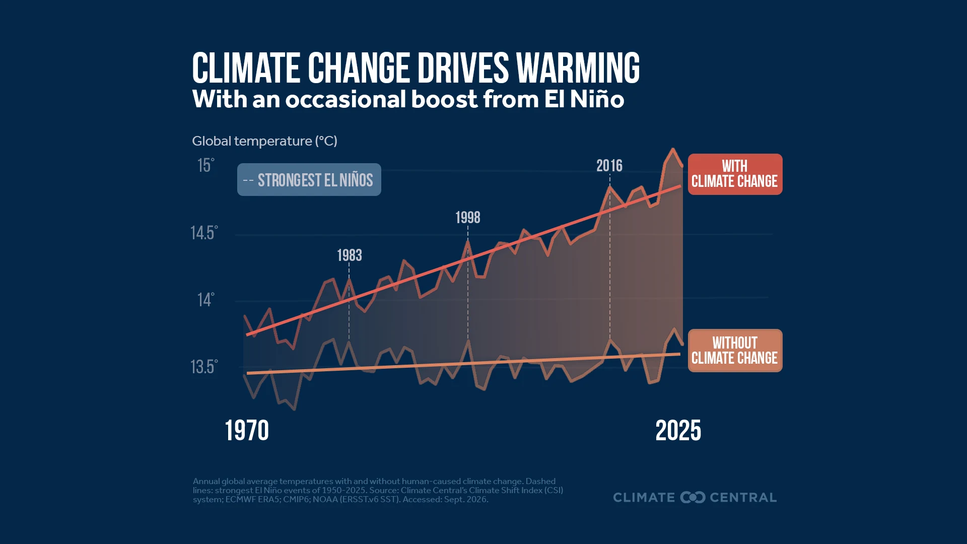
El Niño can temporarily boost global average temperatures by a few tenths of a degree. It can occasionally tip an already-warm year into record-breaking territory. But this effect is far smaller than the influence of human-caused warming on global temperatures.
El Niño’s warming is temporary and regional, while human-caused warming is lasting and global. El Niño warming is a redistribution of heat already stored in the ocean. By contrast, human-caused warming traps additional heat in the atmosphere, affects the entire globe, is amplified over land, and continues pushing temperatures higher regardless of El Niño or other modes of natural climate variability.
Climate Central’s team of climate scientists can answer your questions about El Niño. For interview requests, contact Abbie Veitch (aveitch@climatecentral.org). For requests from the public or private sectors, get in touch with our team.
Visuals
Loading visual assets...
What is El Niño?
El Niño is a natural climate pattern that occurs when easterly trade winds weaken, reducing upwelling cold currents in the eastern tropical Pacific Ocean. As upwelling slows, surface waters in the central and eastern tropical Pacific warm above normal, releasing vast amounts of heat stored in the ocean into the atmosphere. El Niño is the warm phase of the broader El Niño-Southern Oscillation (ENSO) climate pattern. Every two to seven years, sea surface temperatures in the tropical Pacific Ocean flip between warmer-than-average (El Niño) and colder-than-average (La Niña) phases, pausing in the neutral phase between.
How does El Niño affect weather?
ENSO is an influential driver of year-to-year global weather variability. During El Niño events, warm surface waters and associated rising moist air masses shift from the western to the central and eastern tropical Pacific Ocean. This periodic re-positioning of warm water and convective air can disrupt large-scale atmospheric circulation patterns that move heat and moisture from the tropics toward the mid-latitudes. When this disruption reaches mid-latitude jet streams, it can alter temperature and precipitation patterns far beyond the tropical Pacific. El Niño events typically peak in December, with effects lingering into the following year — though the strength and impacts vary considerably from one event to the next.
In the U.S., El Niño is typically associated with a southward shift in the subtropical jet stream, resulting in relatively cool and wet winters across the southern tier and mild winters in Alaska and the Pacific Northwest. El Niño also tends to suppress Atlantic hurricane activity by increasing wind shear in the tropical Atlantic, making it harder for storms to form and intensify (the reverse is true for La Niña). Globally, El Niño can increase drought and wildfire risk in Australia and Indonesia while raising flood risk elsewhere, with effects that can extend to agriculture, fisheries, freshwater availability, and public health across vulnerable regions worldwide.
How do the effects of El Niño and climate change differ?
Naturally occurring weather disruptions from El Niño do not occur in isolation. Human-caused climate change has already elevated the baseline risk of extreme weather worldwide. A strong El Niño can compound those risks further. A powerful El Niño event can amplify temperature and precipitation extremes on an already-overheating planet, placing additional strain on food systems, water supplies, and public health, particularly in communities least equipped to cope.
There are two other fundamental differences between El Niño and human-caused climate change:
By releasing heat stored in the ocean, El Niño can temporarily boost global average temperatures by roughly 0.1°C to 0.3°C, occasionally tipping an already-warm year into record-breaking territory. While this effect can be consequential, it is far smaller in magnitude than the 1.4°C of warming above pre-industrial levels due to human-caused climate change.
Unlike human-caused warming, which traps additional heat in the atmosphere and raises the planet’s baseline temperature continuously, El Niño redistributes heat already stored in the ocean. As a result, El Niño’s warming pattern is temporary and regional, producing a patchwork of warmer and cooler areas globally. By contrast, human-caused warming is globally pervasive, amplified over land, and ever-rising.