
Climate Shift Index Alerts
Using our Climate Shift Index (CSI) system (including Ocean CSI and Tropical Cyclone CSI), we issue alerts when select extreme weather events — such as heat waves, hurricanes, or wildfires — are made more likely by human-caused climate change.
Explore the log below to see a sampling of recent events linked to climate change, and use the CSI and Ocean CSI map tools to investigate daily conditions in your area.
Want to receive these alerts? Join our email list.
Climate change amplifies extreme heat across much of South America
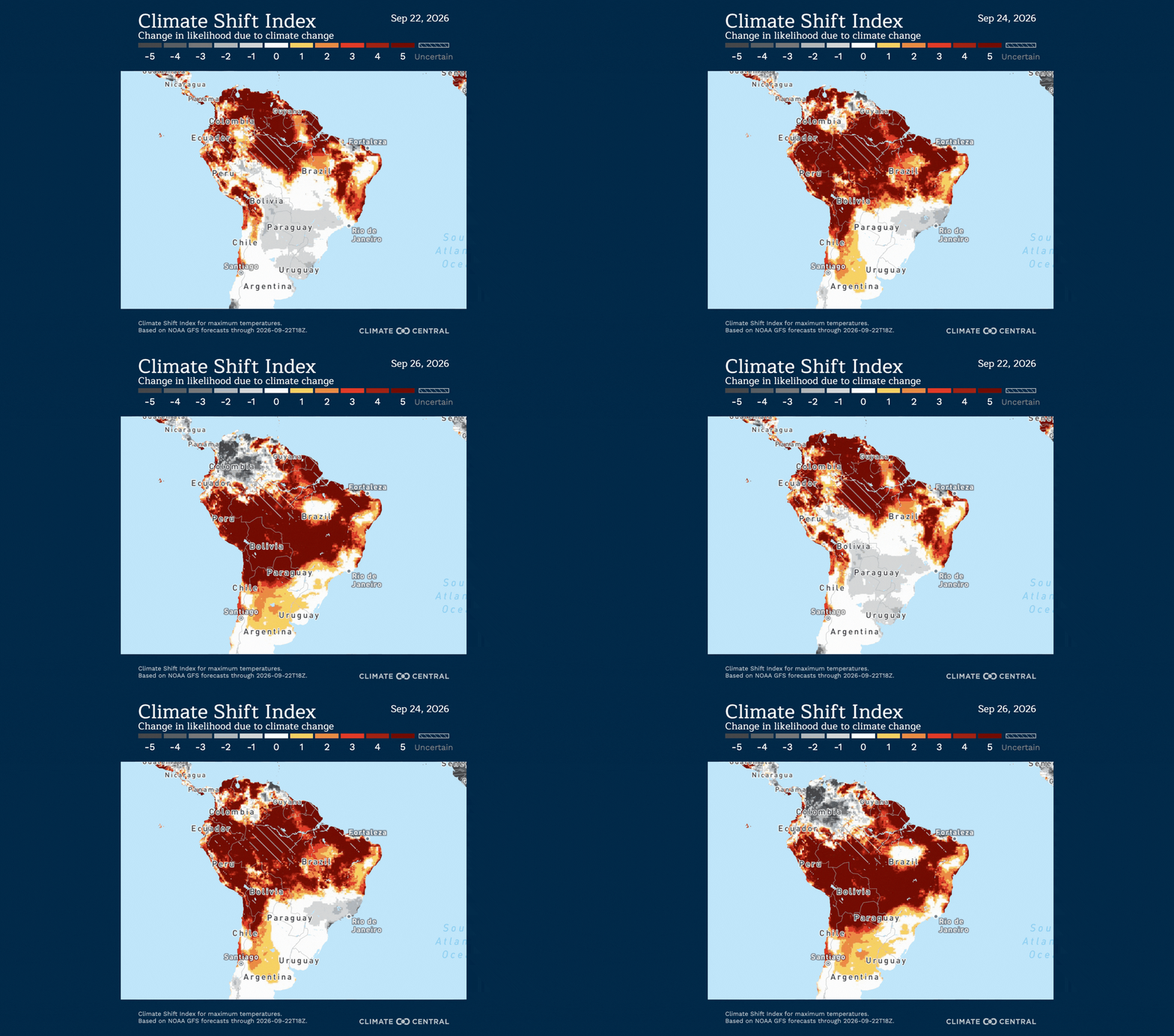
Extreme heat is forecast across large portions of South America this week, with temperatures reaching up to 47°C (117°F) in some areas. Climate change made the exceptional heat at least five times more likely across millions of square kilometers, affecting more than half the continent’s population.
Unusual temperatures:
Persistent warmth is affecting large portions of the northern and tropical regions of South America this week.
From September 22-26:
Northern and central Brazil, Colombia, Venezuela, and French Guiana: Temperatures of 33-39°C (91-102°F), which are 2-7°C (4-13°F) above normal for this time of year.
Peru: Temperatures of 34-39°C (93-102°F) in northern and eastern portions of the country, with temperatures up to 41°C (106°F) possible in the southeast later this week. These temperatures are 3-10°C (5-18°F) above normal for this time of year.
From September 24-26:
Northern Argentina, western and northwestern Paraguay, and Bolivia: Temperatures up to 41-47°C (106-117°F), which are up to 9-15°C (16-27°F) above normal for this time of year.
The current warmth is consistent with the International Center for Research on the El Niño Phenomenon’s (CIIFEN) regional outlook, which forecasts above-normal temperatures across much of South America for September-November as El Niño strengthens.
El Niño is a naturally occurring climate pattern, but it is unfolding against a warmer background due to human-caused climate change, which can amplify heat during El Niño-influenced periods
Climate influence:
Climate Shift Index (CSI) levels of 5 — the highest possible — are forecast across much of South America, with the highest concentrations in Brazil, Venezuela, and Peru from September 22-26, meaning human-caused climate change made this extreme heat at least five times more likely. This signals an exceptional climate-influenced event.
From September 22-26, more than 251 million people, or over half of the population, across South America are forecast to experience at least one day with average temperatures reaching a CSI 5 or higher, indicating an exceptional influence from climate change.
Temperatures made at least five times more likely by human-caused climate change are projected to affect approximately 12.8 million square kilometers (4.9 million square miles) — an area more than 3 times larger than India.
Climate change boosts extreme ocean heat fueling Hurricane Polo
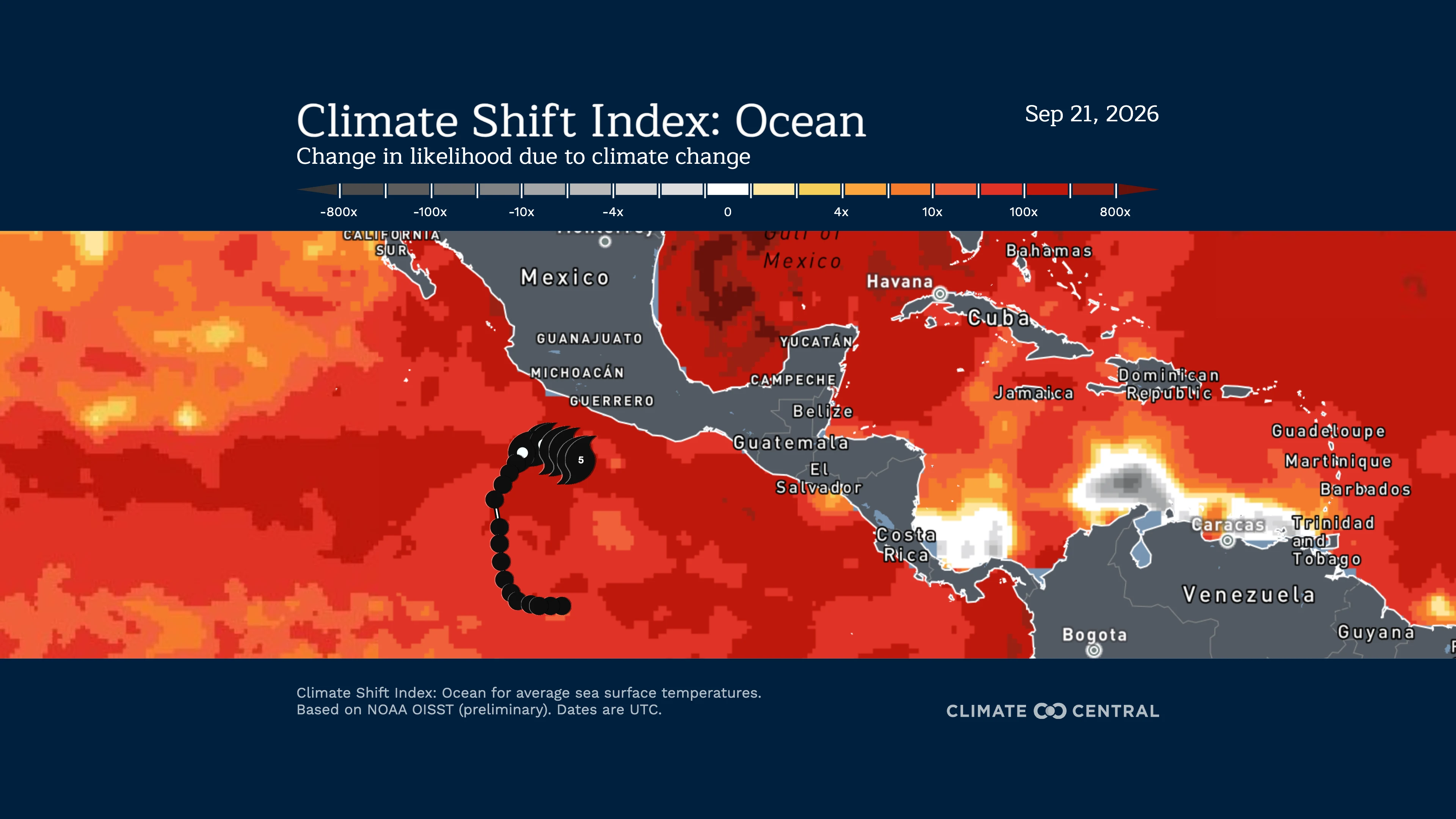
On September 22, Hurricane Polo underwent extreme rapid intensification, reaching Category 5 strength with sustained winds of 180 mph off the southwestern coast of Mexico. As of September 23, Polo has weakened to a Category 4 hurricane with sustained winds of 150 mph and is slowly moving northward.
On September 22, Hurricane Polo underwent extreme rapid intensification, reaching Category 5 strength with sustained winds of 180 mph off the southwestern coast of Mexico. As of September 23, Polo has weakened to a Category 4 hurricane with sustained winds of 150 mph and is slowly moving northward.
Heavy rainfall associated with the storm is expected to bring life-threatening flooding and mudslides to coastal communities along southwestern Mexico. The moisture from Hurricane Polo is also increasing the risk of dangerous flooding in the U.S. Southwest.
Exceptionally warm Pacific sea surface temperatures (SSTs) exceeding 31°C (88°F) helped fuel the storm’s rapid intensification. Human-caused climate change has made these unusually warm ocean temperatures at least 100 to 200 times more likely, significantly enhancing the storm’s potential strength.
Note: This is NOT a storm forecast. Visit the National Hurricane Center for the latest updates and information on how the storm is evolving.
How is climate change influencing this storm?
Sea surface temperatures (SSTs) along the path of Hurricane Polo were up to 1.5°C (2.7°F) warmer than they would have been in a world without human-caused climate change.
Warmer SSTs are associated with increased risk of rapid intensification.
Climate change added at least 6 mph to the storm’s peak sustained wind speed, also known as its lifetime maximum intensity.
This calculation is based on preliminary track and data.
Over the past several months, the Pacific Ocean has been experiencing a historic and climate-change-driven marine heat wave.
Climate change amplified record heat amid severe drought
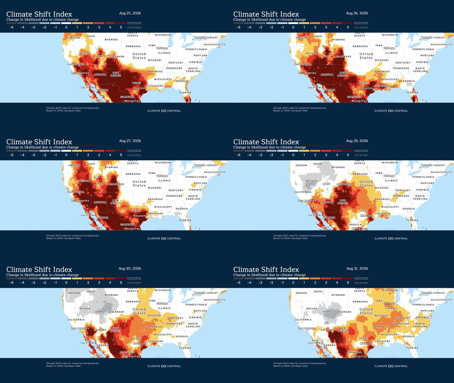
A persistent heat dome helped drive the warmest August on record for the lower 48 U.S. states, while exceptionally dry conditions worsened drought across parts of the southern Plains. Climate change increased the likelihood of extreme daytime heat, with many drought-affected areas experiencing weeks of unusually hot temperatures, with the potential to worsen dry conditions.
Unusual temperatures:
A persistent heat dome extended across the Southwest and central and southern Plains during August, helping maintain prolonged heat across the region.
August 2026 was the warmest August on record for the lower 48 U.S. states, which included the warmest average daytime maximum temperatures. Colorado and New Mexico each recorded their warmest August on record, while New Mexico also had its warmest average daytime maximum temperatures on record.
Drought conditions:
Precipitation was especially limited across the southern Plains. Texas and Oklahoma each received less than 30% of their typical August precipitation. August 2026 ranked as the third driest on record in Texas and the fifth driest in Oklahoma.
By late August, persistent heat and dry conditions were contributing to a rapid deepening of drought across the region. The U.S. Drought Monitor reported that excessive heat worsened agricultural impacts in southern Kansas and southeastern Colorado, while drought continued to expand across Texas, Oklahoma, and eastern New Mexico.
The USDA reported widespread short or very short topsoil moisture across Colorado, Kansas, New Mexico, Oklahoma, and Texas at the end of August, leaving dry soils across much of the region heading into winter wheat planting.
Warmer temperatures can worsen drought by increasing atmospheric moisture demand and pulling more water from soils and plants, further drying soils and stressing vegetation. By September 1, 2026, nearly 79% of the combined area of Oklahoma, Texas, Kansas, Colorado, and New Mexico was experiencing moderate drought or worse.
According to Climate Central analysis, about 67% of 243 U.S. locations analyzed have already shifted to warmer planting zones from the past (1951-1980) to the present (1995-2024). Alaska, the Northwest, and the Southwest have been most affected.
Climate influence:
Across the drought-affected area, August daily maximum temperatures leading up to September 1 averaged 6.3°F (3.5°C) above normal.
Climate-change-influenced daytime heat overlapped extensively with the drought. More than half (52%) of the drought-affected area experienced at least 20 days in August with daytime high temperatures at CSI 2 or higher, meaning those temperatures were made at least twice as likely by human-caused climate change.
Major to Extreme HeatRisk across Central and Southern U.S. made more likely by climate change
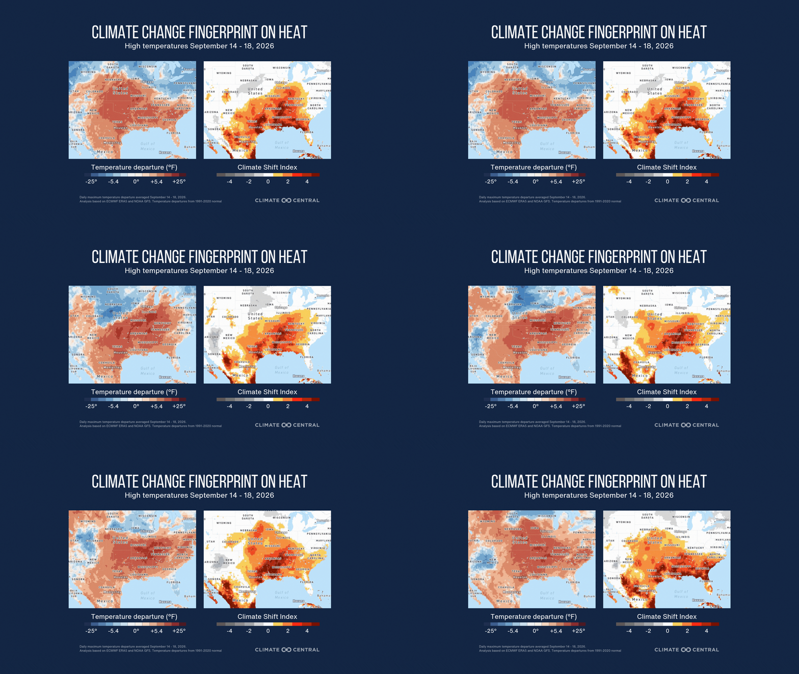
Dangerous, near-to-all-time record heat is expected to impact more than a dozen states this week. For more than 65 million Americans, these lingering, late-summer temperatures are made at least three times more likely by human-caused climate change.
Unusual temperatures:
A persistent, late-season heat dome across the south-central U.S. and Southeast is driving heat this week, with above-average, near-record heat extending from Texas and the Southern Plains through the Lower Mississippi Valley and the Southeast.
Highs in the low 100s will stretch from eastern Texas and Oklahoma through Louisiana, Arkansas, southern Missouri, northern Mississippi, and southern Tennessee early this week. Temperatures between 101°F and 106°F are forecast in parts of these states between September 14 and September 18.
Elsewhere across the South, highs will reach the mid-to-upper 90s, including much of the Gulf Coast, Georgia, Alabama, and surrounding areas.
These temperatures are well above normal for mid-September, with high temperatures 13-20°F above normal across much of the Central Plains and southern U.S. Portions of central Oklahoma and the Mississippi and Ohio valleys are forecast to reach 20-22°F above normal.
According to the National Weather Service, Major to Extreme HeatRisk is expected to impact a dozen states, including Arkansas, Kentucky, Louisiana, Mississippi, Missouri, Oklahoma, and Texas.
Climate influence:
Climate Shift Index (CSI) levels of 3, are forecast across the south-central and southeast United States from September 14 through September 18, meaning human-caused climate change made this extreme heat at least three times more likely. This signals a very strong climate-influenced event.
More than 65 million people across the south-central U.S. and southeast United States will experience at least one day with maximum temperatures reaching a CSI 3 or higher between September 14 and 18.
Temperatures made at least three times more likely by human-caused climate change are projected to affect approximately 580,000 square miles (1.5 million square kilometers) across the southwest, south-central, and southeast United States.
Hurricane Lowell’s torrential Hawaii rainfall linked to climate change boosted Pacific warmth
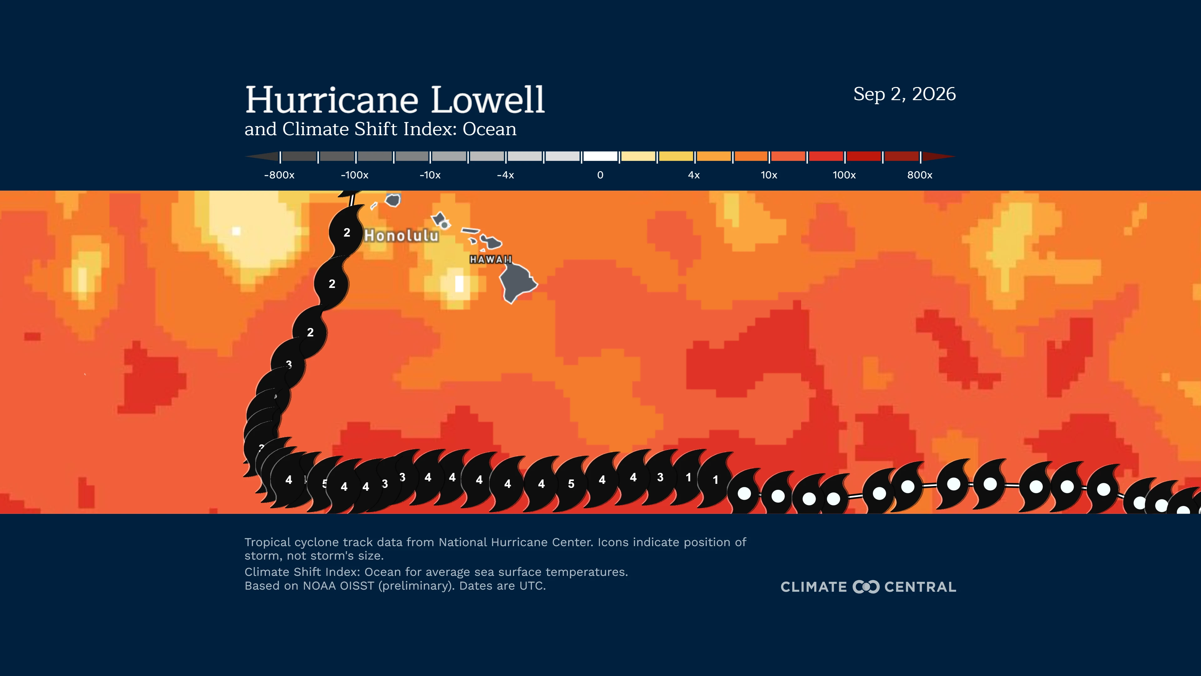
Human-caused climate change boosted the Pacific waters that Hurricane Lowell tracked over for several days, making the unusually warm sea surface temperatures along its path up to 60 times more likely. That added warmth helped to create the torrential rainfall that impacted Hawaii as Lowell approached and then made its closest approach to the islands Labor Day Monday, with totals exceeding 16 to 19 inches over Kauai. The storm washed out roads while prompting flash flood warnings the first-ever tornado watch issued for Hawaii.
Note: This is NOT a storm forecast. Visit the National Hurricane Center for the latest updates and information on how the storm is evolving.
How is climate change influencing Lowell’s rainfall?
Hurricane Lowell tracked over unusually warm Pacific waters throughout its tropical storm and hurricane lifetime. From August 27 through September 1, sea surface temperatures along its path were made 5 to 60 times more likely because of human-caused climate change.
Lowell became a hurricane on September 1 and briefly reached Category 5 intensity on September 2. During this period, it moved over waters about 0.7°C to 1.1°C (1°F to 2°F) warmer than normal, where sea surface temperatures this warm were generally 10 to 20 times more likely because of climate change.
After turning northward between September 5 and 6, Lowell continued north, passing just west of Kauai. As it approached and moved west of Hawaii between September 7 and 8, it crossed waters where sea surface temperatures were about 3 to 8 times more likely because of climate change.
Warmer oceans fuel more evaporation, allowing for additional moisture in the atmosphere. In a warmer world due to climate change, storms like Lowell can produce heavier rainfall faster.
How do we know climate change is influencing this storm?
The Climate Shift Index: Ocean is grounded in peer-reviewed methodology and high-quality data. It quantifies the influence of climate change on sea surface temperatures.
The Ocean CSI indicates how human-caused climate change has influenced the likelihood of daily sea surface temperatures occurring at nearly any location around the world’s oceans.
To request an interview with a Climate Central scientist, please contact Tom Di Liberto at tdiliberto@climatecentral.org.
Climate change fuels extreme heat, flooding and tropical threats across the U.S.
Much of the United States will experience some form of climate-fueled extreme weather this week, from dangerous heat across the Central and Eastern U.S. to heavy rain and flooding threats in Texas, the Grand Canyon, and Southern California. Unusually warm ocean waters are also amplifying tropical systems and the risk of extreme rainfall, underscoring the widespread influence of human-caused climate change.
Climate-Driven Heat in the U.S. South, Southeast, Ohio Valley, Upper Midwest, and Northeast
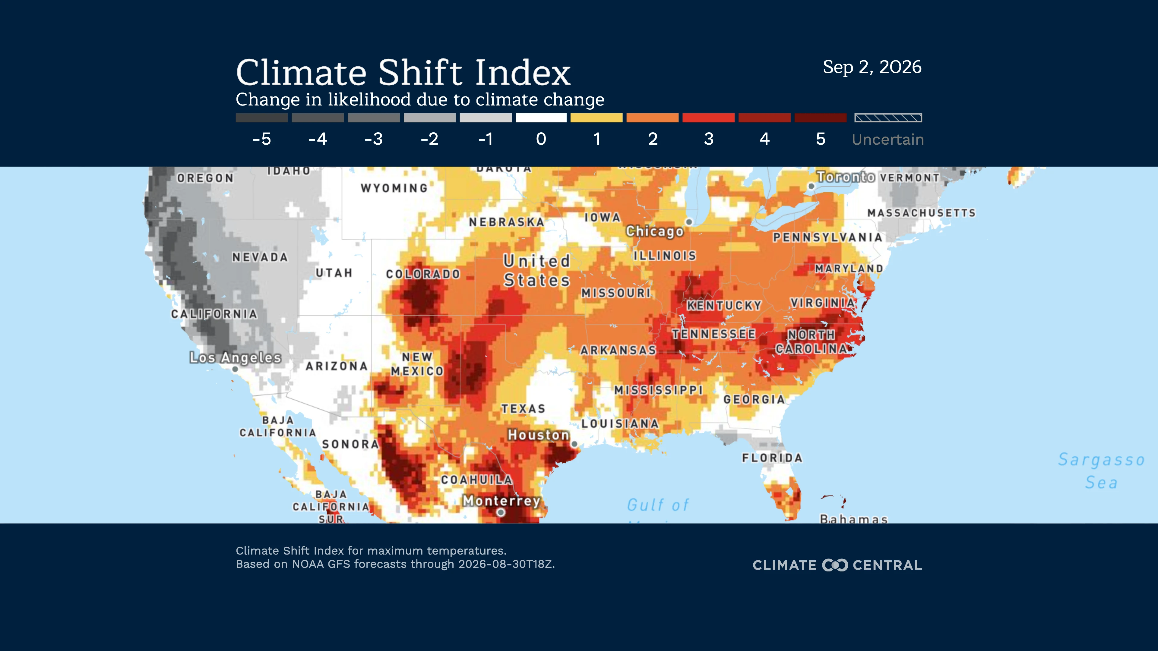
High temperatures are forecast to reach the triple digits across the central and southern Plains, and temperatures are expected to be in the mid-to-upper 90s across the eastern United States through at least Friday, September 4. Near-to-all-time record high temperatures are expected in Arkansas, Delaware, Georgia, Kansas, Kentucky, Mississippi, North Carolina, South Carolina, Texas, Virginia, and West Virginia.
Daily maximum temperatures are forecast to reach a CSI level 3 in cities across multiple regions across the central and eastern United States, including San Antonio, Miami, and Washington, D.C. A CSI 3 indicates that human-caused climate change is making this event at least 3 times more likely, signaling a significant climate change event.
From August 31 through September 4, more than 192 million people across the central and eastern United States will experience at least one day with average temperatures reaching a CSI 3 or higher, indicating a significant influence from climate change.
Tropical Storm Edouard in Gulf to bring rain and floods to Texas
Tropical Depression Five formed over the northern Gulf of Mexico around 1 p.m. CDT Monday, August 31, and strengthened into Tropical Storm Edouard by evening. The National Weather Service is forecasting 3 to 5 inches of rain, with isolated amounts of 6 to 9 inches possible over parts of southeast and eastern Texas. Rainfall rates exceeding 3 to 4 inches per hour at times could lead to flash flooding in urban and other vulnerable areas.
While a tropical storm is not unusual at this time of year, the ocean temperatures it is encountering are. Sea surface temperatures are 2°F to 2.5°F above average for late August. According to the Climate Shift Index: Ocean, this unusual warmth is made at least 200 times more likely by human-caused climate change.
Flooding in Grand Canyon
Climate change amplifies dangerous humid heat across the Gulf Coast
Climate change is fueling dangerous humid heat across the Gulf Coast through the end of August. About 37.5 million people are expected to experience humid heat made more likely by human-caused climate change, with nearly 15 million facing conditions made at least 10 times more likely.
Unusual temperatures:
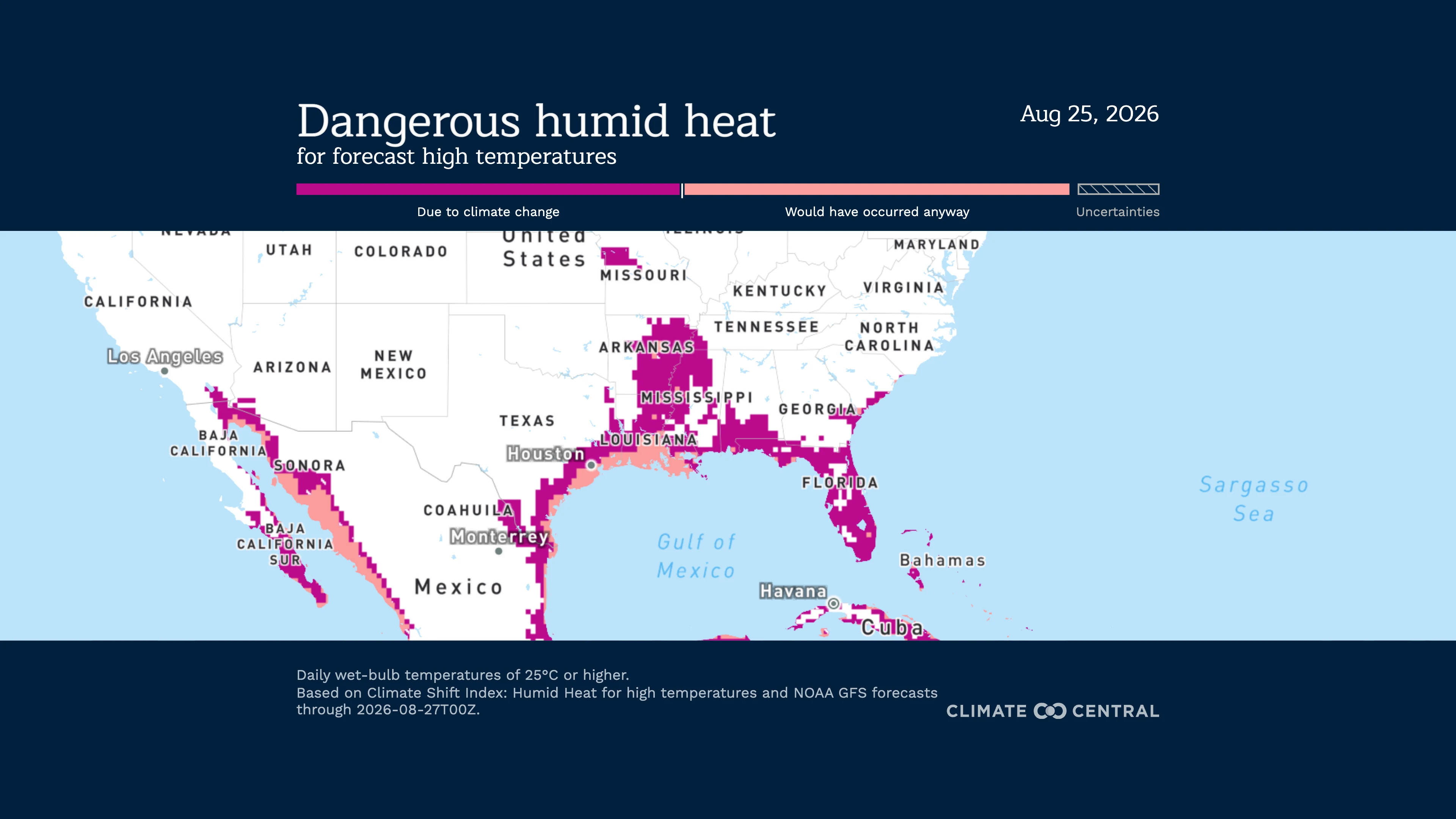
Dangerous humid heat is forecast to affect the entire Gulf Coast from August 24 through the end of the month. A strong upper-level ridge over the southern U.S. is driving the heat by boosting temperatures, while persistent onshore flow from the very warm Gulf of Mexico is supplying abundant moisture and keeping humidity high.
Scientists consider wet-bulb temperatures exceeding 77°F (25°C) dangerous because they can put many people at risk of heat illness.
Wet-bulb temperatures are forecast to reach between 77°F and 79°F (25-26°C) along the Gulf Coast during this time, affecting much of Florida and the entire coastline of Texas. Southern portions of Alabama and Georgia are also expected to experience these dangerous conditions, while wet-bulb temperatures of this magnitude will extend farther north through Louisiana and Mississippi, extending through parts of Arkansas.
Climate influence:
A strong human-caused climate change signal is forecast to influence humid heat across much of the Gulf Coast from August 24 through August 31, extending from coastal Texas to Florida. In the most affected areas, climate change made these humid heat conditions more than 100 times more likely.
Approximately 37.5 million people — 46% of the population across the Gulf Coast states — are forecast to experience humid heat made more likely by human-caused climate change during this event. Nearly 15 million of those people are expected to experience humid heat made at least 10 times more likely due to human-caused climate change.
Climate change is forecast to increase the likelihood of humid heat across approximately 94,000 square miles (24,3459 square kilometers) - about 29% of the Gulf States area.
Warm ocean temperatures in the Gulf that help drive this humidity have been made between 30 and 800 times more likely by climate change.
Climate change amplifies exceptional heat across western and southern U.S.
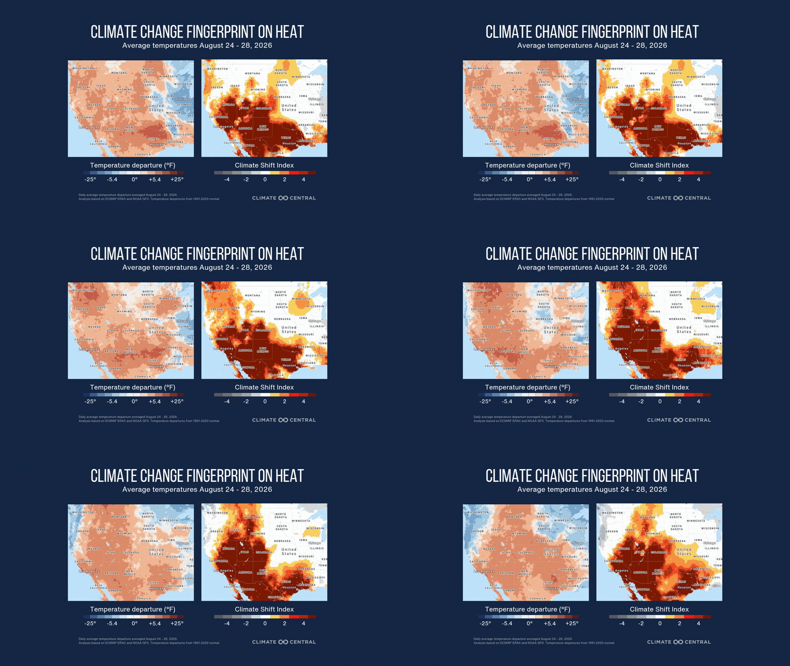
An intense heat dome is expected to bring dangerous temperatures across the western and southern United States through August 28, with some areas reaching 110°F to 115°F. Climate change has made the extreme heat at least five times more likely across large portions of the region, according to Climate Central’s Climate Shift Index.
Unusual temperatures:
Extreme Heat Warnings and advisories have been issued across Central and North Texas for cities including Abilene, Austin, Corsicana, Dallas, Denton, Fort Worth, Hearne, Waco, Waxahachie, and Wichita Falls.
According to the National Weather Service, “Dangerously hot conditions with temperature values up to 111°F” were in the forecast Monday, August 24, with highs reaching up to 107°F Tuesday, August 25.
Extreme heat between 110°F and 115°F is expected in the Southwest, with little overnight relief. Many areas may not cool below 80°F for several nights in a row.
This results in widespread Extreme HeatRisk, which is a level of heat dangerous to anyone without proper hydration or adequate cooling.
The center of this prolonged heat dome driving this hot weather pattern will shift from the Southern Plains to the Desert Southwest by mid-to-late week.
Climate influence:
Climate Shift Index (CSI) levels of 5 — the highest possible — are forecast across the western and southern halves of the United States from August 24 through August 28, meaning human-caused climate change made this extreme heat at least five times more likely. This signals an exceptional climate-influenced event.
From August 24 through August 28, more than 103 million people across the western and southern United States will experience at least one day with average temperatures reaching a CSI 5 or higher, indicating an exceptional influence from climate change.
Temperatures made at least five times more likely by human-caused climate change are projected to affect approximately 1 million square miles (2.6 million square kilometers) of the western and southern United States.