Climate Shift Index Alert•September 24, 2026
Climate change is adding fuel to this weekend’s Nor’easter
September 24, 2026
A developing nor’easter is expected to strengthen along the U.S. East Coast through the weekend, bringing heavy rainfall, strong winds, dangerous surf, and coastal flooding from the Mid-Atlantic into New England. As of September 24, coastal flooding has already affected portions of Virginia and North Carolina, with ocean overwash closing a miles-long stretch of road on the Outer Banks and breaking waves of 12-17 feet forecast along Hatteras Island, North Carolina.
The storm is expected to bring its most significant impacts to the Northeast beginning Friday, with coastal wind gusts of 40-60 mph and widespread rainfall totals of 2-4 inches, with isolated amounts reaching 5 inches on Cape Cod.
Dangerous surf is expected, with coastal flooding possible along much of the Northeast coast Friday through Sunday, including the Jersey Shore, Long Island, Rhode Island, Martha's Vineyard, Nantucket, and portions of coastal New Hampshire and Maine. Breaking waves of 6-17 feet are possible along the Massachusetts coast, while offshore seas near Jeffreys Ledge in the Gulf of Maine could reach 15 feet. Prolonged onshore winds and repeated high tides, amplified by Saturday’s full moon, will increase the risk of coastal flooding, beach erosion, and damage to coastal infrastructure
How is climate change influencing this storm?
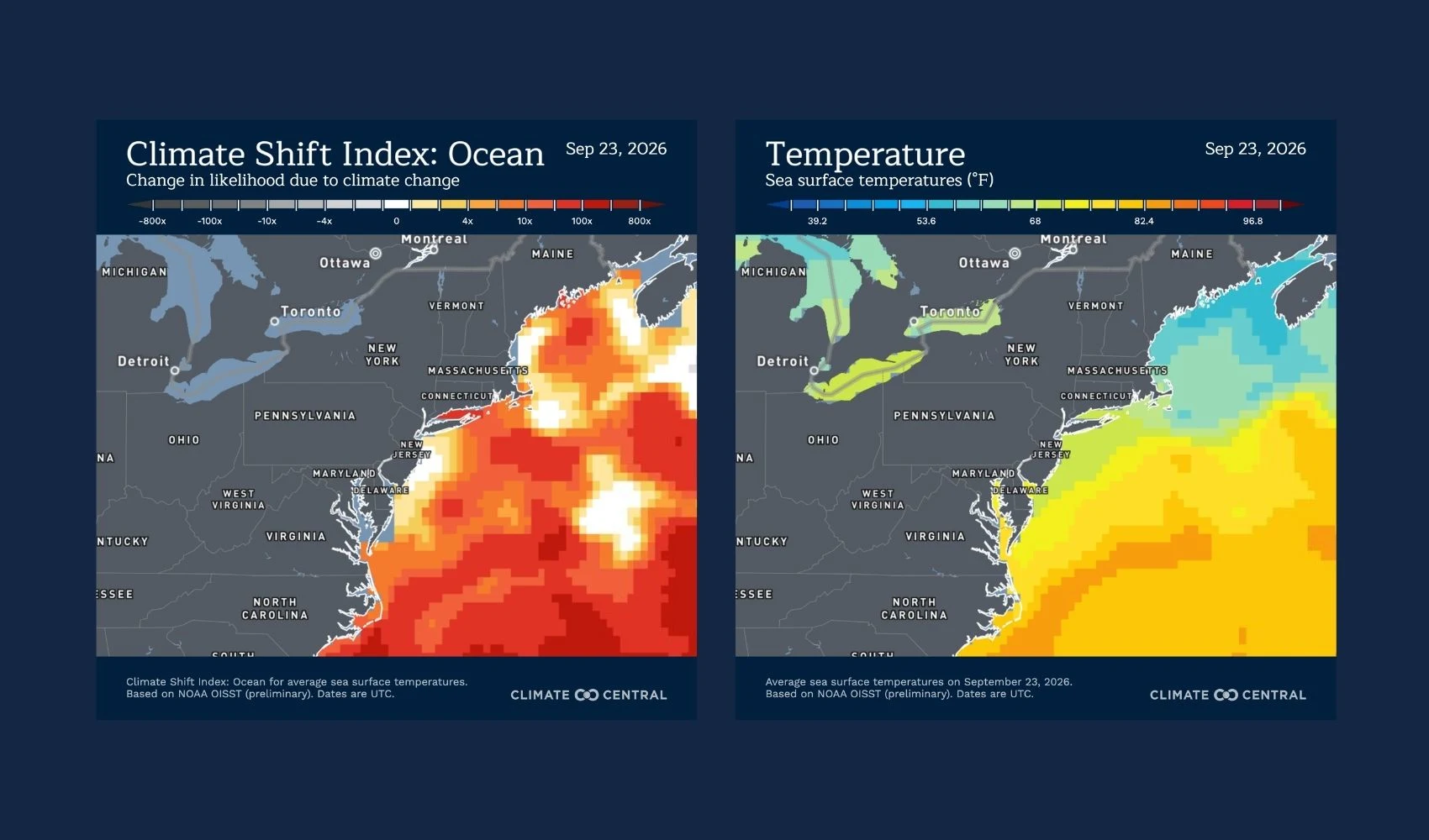
The developing nor’easter is forming over exceptionally warm Atlantic waters off the Mid-Atlantic coast, where sea surface temperatures of 81-83°F are 2-4.5°F above normal.
According to Climate Central’s Climate Shift Index: Ocean, these unusually warm waters have been made 10 to 50 times more likely by human-caused climate change.
As the storm moves northward, it is expected to travel over unusually warm waters of 75-80°F, approximately 2-4°F warmer than normal.
Ocean CSI along its forecast path indicates that these ocean temperatures are 10 to 50 times more likely, and up to 70 times more likely in some areas, due to climate change.
Warmer waters can increase evaporation and supply additional moisture to the atmosphere, potentially enhancing rainfall as the nor’easter moves along the East Coast.
Human-caused climate change is also contributing to rising sea levels and exacerbating flooding outlooks along the East Coast. Tide forecasts for Lewes, Delaware, for example, indicate that the region could experience moderate coastal flooding in the coming days, but would experience only minor flooding without the influence of human-caused sea level rise. Similarly, New York City is expected to experience minor coastal flooding, but without the influence of human-caused climate change, sea levels would not reach flood levels at all.
What do experts say?
Dr. Zachary Labe, a Climate Scientist at Climate Central, said:
“Climate change is raising sea levels along the East Coast, so coastal communities are starting every storm from a higher water level. That makes flooding and erosion from nor’easters like this one more likely and more severe.”
How do we know climate change is influencing this storm?
The Climate Shift Index: Ocean is grounded in peer-reviewed methodology and high-quality data. It quantifies the influence of climate change on sea surface temperatures.
The Ocean CSI indicates how human-caused climate change has influenced the likelihood of daily sea surface temperatures occurring at nearly any location around the world’s oceans.
To request an interview with a Climate Central scientist, please contact Abbie Veitch at aveitch@climatecentral.com.
Other resources
Access photorealistic, street-level visuals of storm surge flooding risks using Climate Central’s FloodVisionⓇ tool. Learn more here.