

Climate Matters
Heat Season Power Outages
Power outages and hot weather are a dangerous mix. Heat season outages now happen 60% more often than during 2000-2009.

Climate Matters•July 23, 2025•Reuse this content
Multi-day heat streaks are dangerous. They worsen air quality and put people at risk from heat-related illness. They can also strain the grid and lead to power outages.
They’re also becoming more common, according to Climate Central analysis of the changing frequency of extreme heat streaks in 247 cities across the U.S. from 1970 to 2024.
The annual number of extreme heat streaks increased in 198 (80%) of the cities analyzed.
On average, these 198 cities now experience two more extreme heat streaks each year than in the early 1970s.
As heat-trapping pollution warms the planet, extreme heat events are becoming more frequent and intense, escalating heat risks across the globe.
This Climate Matters analysis is based on open-access data from the National Oceanic and Atmospheric Administration (NOAA). See Methodology for details.
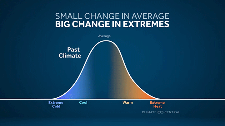
More frequent and intense extreme heat — the deadliest type of weather in the U.S. — is a direct result of a warming planet.
As heat-trapping pollution warms the planet, extreme heat events are becoming more frequent and intense for billions of people, escalating heat risks across the globe.
When extreme heat lingers for days during heat waves, or heat streaks, the risk of heat-related illness rises — particularly for children, pregnant people, and weather-exposed workers among others.
Cooling demand also surges during heat streaks. This can strain the grid, leading to power outages that put vulnerable people at higher risk.
Heat streaks can also worsen air quality by trapping harmful pollutants in the air we breathe and fueling the formation of ground-level ozone, worsening health issues for people with respiratory illness.
Multi-day heat streaks are dangerous for these and other reasons. They’re also becoming more common in many major U.S. cities.

To understand how multi-day extreme heat events are changing in our warming climate, Climate Central analyzed the changing frequency of extreme heat streaks in 247 cities across the U.S. from 1970 to 2024.
This analysis defines an extreme heat streak as a period of three or more consecutive days with maximum temperatures exceeding the 90th percentile of each location’s daily maximum temperatures during the 1991-2020 normal period (see Methodology).
In other words, these extreme heat streaks reflect the hottest 10% of daily maximum temperatures recorded in a location during 1991-2020.
Across the 247 cities analyzed, this temperature threshold ranged from 66°F in Juneau and Anchorage, Alaska to 100°F in Yuma, Arizona.

As average temperatures rise and heat extremes occur more often, many places are experiencing more extreme heat streaks.
From 1970 to 2024, the annual number of extreme heat streaks increased in 198 (80%) of the 247 cities analyzed.
On average, these 198 locations now experience two more extreme heat streaks than in the early 1970s.
Cities across the Southwest, Northeast, Ohio Valley, and Southeast have experienced the largest average increase in the frequency of extreme heat streaks.
The cities that have experienced the largest increase (all with five more streaks than in the early 1970s) are: Nashville, Tenn.; Raleigh, N.C.; Wheeling, W.Va.; and Wilkes Barre, Pa.
Climate change is increasing exposure to dangerous extreme heat for billions across the globe.
Heat is the leading cause of weather-related deaths in the U.S. In 2023, a record 2,325 people died from heat in the U.S. alone, though such figures are widely thought to be an undercount.
Exposure to extreme heat makes it difficult for our bodies to cool off, and can result in heat-related illnesses including heat cramps, heat exhaustion, and even fatal medical emergencies such as heat stroke.
Extreme Weather Toolkit: Extreme Heat provides quick facts and recent Climate Central resources on extreme heat trends and local impacts in the U.S. and across the globe.
Extreme heat can affect everyone, but some face greater risks of heat-related illness and mortality than others.
Children, adults over 65, pregnant people, and people living with illness are among those most at risk to heat-related illness.
Extreme Heat Risks for Children reviews how climate change is driving more frequent and intense extreme heat that is especially dangerous for children.
Climate Change Nearly Doubled Pregnancy Heat Risk Days in U.S. shows that human-caused climate change has at least doubled the average annual number of pregnancy heat-risk days in 222 countries including the U.S. in recent years.
Humid heat is especially dangerous for weather-exposed workers — presenting health and safety hazards, causing heat-related illness, injury, or death, and impacting livelihoods through lost labor hours and wages.
Rising Heat Risks for Workers shows that risky humid heat is becoming more frequent in cities across the U.S.
Climate Central’s Climate Shift Index system provides tools, data, custom maps, and local alerts to answer this question in real-time. Here are three ways to use the Climate Shift Index this summer:
Use the tools. Climate Central’s Climate Shift Index map tool shows which parts of the world are experiencing high Climate Shift Index levels, every day.
Access KML to create custom Climate Shift Index maps. Fill out this form to receive CSI maps in KML format, and create custom Climate Shift Index maps.
Sign up for alerts. Sign up here to receive custom email alerts when strong Climate Shift Index levels are detected in your local area.
The National Integrated Heat Health Information System HEAT.gov is a hub for information to support heat resilience in the U.S. Check out HeatRisk, an interactive map tool from the National Weather Service now available for the contiguous U.S. This color-numeric index shows current and forecast risk of daily local heat-related impacts. The CDC’s Heat and Health Tracker maps daily rates of heat-related illnesses across the U.S.
Submit a request to SciLine from the American Association for the Advancement of Science or to the Climate Data Concierge from Columbia University. These free services rapidly connect journalists to relevant scientific experts.
Browse maps of climate experts and services at regional NOAA, USDA, and Department of the Interior offices.
Explore databases such as 500 Women Scientists, BIPOC Climate and Energy Justice PhDs, and Diverse Sources to find and amplify diverse expert voices.
Reach out to your State Climate Office or the nearest Land-Grant University to connect with scientists, educators, and extension staff in your local area.
Daily maximum temperature data from 1970 to 2024 were obtained from the Applied Climate Information System, which is developed, maintained, and operated by NOAA’s Regional Climate Centers.
This analysis defines an extreme heat streak as a period of three or more consecutive days with maximum temperatures exceeding the 90th percentile of each location’s daily maximum temperatures during the 1991-2020 normal period.
The reported change in annual frequency of extreme heat streaks from 1970-2024 was calculated using linear regression.
Climate Matters © 2025 by Climate Central is licensed under CC BY 4.0
This license grants permission to use, distribute, and reproduce all text, graphics, and multimedia content published on this page in any medium, provided that Climate Central is credited per the CC BY 4.0 license.
Permission to use data and other materials published on this page is granted for non-commercial uses, commercial news purposes, and educational purposes as governed by Climate Central's Terms of Use.

