
Climate Matters•October 18, 2023•Reuse this content
Wettest Seasons in U.S. Regions
KEY CONCEPTS
Precipitation feeds regional water supplies, agriculture, ecosystems, industry, and more.
But climate change is altering the water cycle — and precipitation patterns.
Climate Central assessed seasonal precipitation patterns over the last 53 water years across the contiguous U.S.
Parts of the West and Northwest receive most of their annual precipitation during winter, while the Plains, Upper Midwest, and parts of the Southwest rely far more on summer precipitation.
Changing precipitation patterns in our warming climate threaten the reliability of water supplies for drinking, irrigation, ecosystems, and industry.
Download .kml versions of seasonal precipitation maps


Changing climate, changing precipitation
Clean, abundant water supplies; agriculture and food; tourism, recreation, and industry; forests and freshwater ecosystems. Precipitation is essential for all of these and more.
But climate change is altering the water cycle — changing the timing, distribution, amount, and intensity of precipitation across the U.S. and around the world.
Warmer temperatures increase evaporation over the ocean and land surface, driving more moisture into the atmosphere and enhancing extremes: more heavy downpours in some areas, intensifying droughts in others, and declining mountain snowpack.

Past precipitation trends in the U.S.
Since 1901, there’s been an overall increase in precipitation in the U.S., but trends vary significantly across regions. While precipitation has generally increased in the Northeast, Midwest, Great Plains, Ohio Valley, and South, it has generally decreased in the West and Southwest.
There’s also been a more recent shift in precipitation patterns. Changing Precipitation Normals, a comparison of the last two normal periods (1991-2020 and 1981-2010), shows that:
Annual average precipitation has increased east of the Rockies and decreased to the west, especially in the Southwestern U.S.
Seasonal averages show high regional variation, with a strong winter wetting signal in the North Central U.S., and strong summer and fall drying signals throughout the West, Southwest and Northwestern U.S.
Changing precipitation patterns threaten the reliability of water supplies for drinking, irrigation, ecosystems, and industry in parts of the U.S.
Managing and supplying water throughout the year with shifting precipitation patterns, aging infrastructure, and changing water demands is a challenge in our changing climate.

Wettest seasons in U.S. regions
Understanding average seasonal precipitation patterns can help identify places that may face high water supply vulnerability in our warming climate.
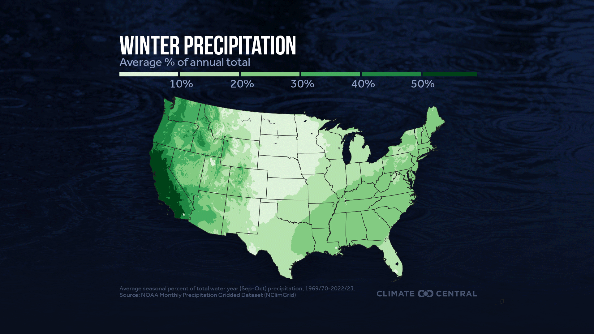
Climate Central used over five decades of rainfall data (1969-70 through 2022-23) to summarize how total annual precipitation is distributed across the four seasons in the contiguous U.S.
Winter precipitation dominates the total annual rainfall received in large areas of the western U.S. — especially in California and much of the Northwest. This means that regional water supplies are tightly coupled to year-to-year variation in winter precipitation.
If winter precipitation is a bust in these areas, there’s far less water to meet demand throughout the rest of the year.
Conversely, abundant winter precipitation (as during the back-to-back atmospheric river events of 2023) can alleviate drought and recharge reservoirs.
Winter precipitation contributes far less to annual totals across the Northern Rockies and Plains and parts of the Upper Midwest. In both regions, summer precipitation instead dominates annual precipitation totals — especially in Minnesota, the Dakotas, and Nebraska.
By contrast, spring and fall precipitation don’t dominate the annual precipitation totals in any region; each season accounts for approximately one-quarter of annual precipitation in most regions.

Wettest seasons in U.S. states
Many states in the Northeast and Ohio Valley receive about one-quarter of their total annual precipitation in each of the four seasons.
By contrast, 14 states —including many in the West, Northwest, Upper Midwest, and Northern Rockies and Plains — receive at least one-third of their total annual precipitation in a single season. Among these states, the dominant precipitation season is either winter or summer.
Nine states receive at least 40% of their annual precipitation in a single season. The lopsided seasonal distribution in these places may make them more vulnerable to both year-to-year variability and to the long-term precipitation shifts due to our warming climate.
| State | Winter | Spring | Summer | Fall |
|---|---|---|---|---|
| California | 52% | 26% | 3% | 19% |
| North Dakota | 8% | 26% | 45% | 21% |
| New Mexico | 15% | 16% | 43% | 27% |
| Minnesota | 9% | 25% | 42% | 25% |
| Florida | 17% | 20% | 41% | 23% |
| Oregon | 41% | 27% | 8% | 25% |
| Nebraska | 8% | 33% | 40% | 20% |
| South Dakota | 8% | 32% | 40% | 20% |
| Washington | 40% | 24% | 9% | 28% |
Shifting precipitation in a warming climate
Future shifts toward wetter or drier seasons could be very disruptive for ecosystems, agriculture, and water management strategies that have all adapted to specific seasonal precipitation patterns in each region.
Warmer air holds more moisture, increasing the potential for heavy rainfall (and resulting flood risk) in a warming climate. For every 1°F of warming, the air can hold an extra 4% of moisture. The U.S. has already warmed by 2.6°F since 1970 — meaning our atmosphere can hold about 10% more moisture on average.

Climate models project a shift toward less precipitation across all seasons in the southwestern U.S. and more winter and spring precipitation in the northern U.S.
The Climate Explorer tool from the U.S. Global Change Research Program shows how our warming climate is projected to affect seasonal and total annual precipitation across the contiguous U.S. The interactive tool can be used to search by city or zip code, modify future warming scenarios, and visualize the data for any decade through the end of this century.
Learn more in Climate Central’s related Extreme Weather Toolkits:
LOCAL STORY ANGLES
What’s the precipitation outlook in your area for the 2024 water year?
On Thursday, October 19, NOAA’s Climate Prediction Center (CPC) will release the U.S. outlook for winter, covering temperature, precipitation, and drought conditions for December 2023 through February 2024. Register for NOAA’s media briefing on October 19 from 11 am to 12 pm EDT, and check the CPC site for the detailed outlook.
Researchers at the University of California provide detailed analysis of the odds that the 2024 water year (October 2023 through September2024) will reach 100% of normal precipitation totals for the western U.S.
How has past precipitation (annual and seasonal) changed near you?
Check NOAA/NCEI’s gridded maps of precipitation trends by season to see how winter, spring, summer, and fall precipitation have changed in your area over a recent 30-year period (1991-2020) and longer term (1896-2020).
How could precipitation change in the future with different levels of warming?
Use the U.S. Global Change Research Program’s The Climate Explorer tool to see how our warming climate is projected to affect seasonal and total annual precipitation near you. The interactive tool can be used to search for your city or zip code, modify future warming scenarios, and visualize the data for any decade through 2090. For a global view, check the IPCC WGI Interactive Atlas, which maps projected annual and seasonal precipitation change globally under 1.5°C, 2°C, and other future warming scenarios.
FIND EXPERTS
Submit a request to SciLine from the American Association for the Advancement of Science or to the Climate Data Concierge from Columbia University. These free services rapidly connect journalists to relevant scientific experts.
Browse maps of climate experts and services at regional NOAA, USDA, and Department of the Interior offices.
Explore databases such as 500 Women Scientists, BIPOC Climate and Energy Justice PhDs, and Diverse Sources to find and amplify diverse expert voices.
Reach out to your State Climate Office or the nearest Land-Grant University to connect with scientists, educators, and extension staff in your local area.
METHODOLOGY
Precipitation data for the contiguous United States was obtained from NOAA’s Monthly U.S. Climate Gridded Dataset (NClimGrid). This analysis defines the water year as October 1st - September 30th. Average seasonal precipitation over the water year was calculated using data from the 1969/70 water year through the 2022/23 water year. Precipitation refers to total liquid and solid precipitation as documented by NCEI and Durre et al. (2022).
Climate Matters © 2023 by Climate Central is licensed under CC BY 4.0
This license grants permission to use, distribute, and reproduce all text, graphics, and multimedia content published on this page in any medium, provided that Climate Central is credited per the CC BY 4.0 license.
Permission to use data and other materials published on this page is granted for non-commercial uses, commercial news purposes, and educational purposes as governed by Climate Central's Terms of Use.