
Climate Matters•October 12, 2021•Reuse this content
Picturing Our Future
KEY CONCEPTS
About 50 major cities around the world are at risk of losing most of their developed areas to unremitting sea level rise over the next century and beyond. New research from Climate Central scientists, in collaboration with others from Princeton University and the Potsdam Institute for Climate Impact Research in Germany, shows that nations will need to mount globally unprecedented defenses to protect populations in these areas under the 3°C emissions pathway.
The peer-reviewed research has enabled Climate Central to develop Picturing Our Future, a collection of powerful visual tools to communicate the future risks of warming and to show what we can save.
Interactive Google Earth images
Flyover videos
Photorealistic illustrations
Animated GIFs
We have the opportunity now to change this flooded future. Meeting the most ambitious goals of the Paris Climate Agreement will likely reduce exposure by roughly half, allowing nations to avoid building expensive and unprecedented defenses or abandoning many major coastal cities.
Picturing Our Future is a new collection of science-based videos and visualizations comparing potential outcomes for nearly 200 landmarks and iconic neighborhoods around the world. Based on precise, multi-century sea level rise projections, they incorporate new high-resolution data from Climate Central’s Coastal Risk Screening Tool and images from Google Earth.
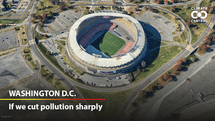
Interactive Google Earth images show the difference between 1.5°C and 3°C of warming for hundreds of locations.
Interactive Google Earth Image: Santa Monica Pier, Santa Monica, California
Interactive Google Earth Image: Robert F. Kennedy Memorial Stadium, Washington, DC
At 1.5°C of warming (2.7°F), research shows we could expect about 1.5 feet (0.48 m) of mean global sea level rise by 2100. Even if we are able to reduce greenhouse gas emissions in the coming decades, sea level will continue to rise because carbon dioxide remains in the atmosphere for centuries and because of possible feedback loops such as thawing permafrost. In the more distant future, sea levels are projected to reach about 9.5 feet (2.9 m).
At 3°C (5.4°F) of warming, sea levels may ultimately rise as high as 21 feet (6.4 m). The images and videos represent a wide range in future time scales. Determining how rapidly seas will rise depends on complex ocean-ice interactions and will play out over hundreds of years. But the consequences of today’s heat-trapping pollution for future sea level are largely irreversible.
Videos and illustrations show future flooding in major metropolitan areas
Photorealistic Images: Plaza de la Catedral, Havana, Cuba
Flyover Videos: Global Tour
Climate Central created fly-over videos and realistic renderings that contrast the projected future sea levels in coastal cities around the world where Google Earth 3-D building data is available. And we worked with visual artist Nickolay Lamm to create photorealistic illustrations of the multi-century sea level rise consequences of 1.5°C and 3°C of warming at a number of iconic locations identified as vulnerable in the research.
See where the water levels will rise globally
Coastal Risk Screening Tool: Miami, FL
Climate Central’s updated Coastal Risk Screening Tool allows users to compare sea level projections with 1.5°C and 3.0°C scenarios, highlighting the areas that could be saved by reducing our carbon pollution and limiting global warming. Users can select the Warming Choices layer and enter nearly any global coastal address or location to see where land is projected to be below the high tide line. Sliders allow users to see the projected effects set by different amounts of global warming, from 1.0°C to 4.0°C, and choose from roadmap or satellite backgrounds.
LOCAL EXPERTS
SciLine, 500 Women Scientists, 500 Queer Scientists, Diverse Sources or the press offices of local universities may be able to connect you to local experts who can discuss the impact of climate change on sea level rise.
NATIONAL EXPERTS
To speak with the Climate Central co-authors of the research, please contact Peter Girard at pgirard@climatecentral.org, (609) 986-1999
Benjamin Strauss, CEO and Chief Scientist, Climate Central
Scott Kulp, Principal Computational Scientist, Climate Central
METHODOLOGY
As detailed in the newly published peer-reviewed research in Environmental Research Letters, these findings are based on localized long-term sea level projections published in the Proceedings of the National Academy of Sciences of the United States of America (Strauss et al. 2015), overlain against the AI-based coastal elevation dataset CoastalDEM version 1.1 (Kulp and Strauss 2018) and 100-meter-resolution global population density data from WorldPop. Exposure estimates were aggregated to city level using urban agglomeration boundary data from Natural Earth, and aggregated to national level using administrative boundary data from GADM 2.0.
Climate Matters © 2021 by Climate Central is licensed under CC BY 4.0
This license grants permission to use, distribute, and reproduce all text, graphics, and multimedia content published on this page in any medium, provided that Climate Central is credited per the CC BY 4.0 license.
Permission to use data and other materials published on this page is granted for non-commercial uses, commercial news purposes, and educational purposes as governed by Climate Central's Terms of Use.