
Climate Matters•September 7, 2023•Reuse this content
Carbon pollution boosted heat for billions during Earth’s hottest summer

KEY CONCEPTS
Earth just had its hottest Northern Hemisphere summer on record, and many parts of the globe experienced record-shattering and dangerous heat from June through August.
Analysis using the Climate Shift Index®, Climate Central’s daily temperature attribution system, finds that human-caused climate change made the unprecedented heat far more likely.
Nearly half (48%) of the world’s population experienced at least 30 June-August days with a Climate Shift Index (CSI) level 3 or higher — heat made at least three times more likely by climate change.
On each day in June-August, between 1.5 and 4.2 billion people felt a very strong influence of climate change (CSI level 3 or higher).
Heat at CSI level 3 or higher persisted for at least half the June-August period in 79 countries throughout Central America, the Caribbean, the Arabian Peninsula, and parts of Africa.
Countries with the lowest historical emissions experienced three-to-four times more June-August days with CSI level 3 or higher than G20 countries (the world’s largest economies).
Download data: Climate Shift Index (CSI) for June to August 2023, by day and by country
Stay tuned: Our September 13 Climate Matters will review summer 2023 in 247 U.S. cities, including local graphics and climate fingerprints.
Following the planet’s hottest June ever recorded, global temperatures were continuously hotter than any previous July-August period on record. July 2023 was Earth’s hottest month on record.
The record-shattering Northern Hemisphere summer temperatures brought dangerous heat waves to many parts of the globe and fueled wildfires in North America, Europe, and Africa.
Record-breaking summer heat also occurred in the ocean, elevating the risk of rapidly-intensifying tropical cyclones like Hurricane Idalia and coral bleaching events like those impacting Florida and the Caribbean.
Heat waves are the deadliest weather-related hazards, and their rising global frequency and intensity is consistent with well-established scientific understanding of the consequences of carbon pollution—mainly from burning coal, oil, and natural gas.

Global fingerprints of climate change during June-August 2023
When it comes to specific heat events, climate change attribution uses statistical methods to quantify the influence of human-caused climate change on a particular event’s likelihood.
Climate Central’s daily attribution system, the Climate Shift Index (CSI), applies the latest peer-reviewed methodology to map the influence of climate change on temperatures across the globe, every day.
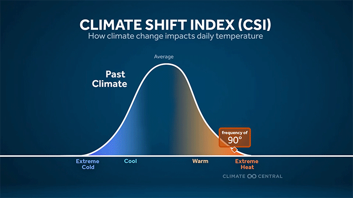
The CSI is based on the relative frequency of daily temperatures in the current climate and in a world without human-caused climate change.
For example, a CSI level of 3 indicates local conditions that were made at least three times more likely due to climate change.
See What is the Climate Shift Index (CSI)? below for more information.
New Climate Central analysis used the Climate Shift Index (CSI) to quantify the influence of human-caused climate change on daily average temperatures experienced in 202 countries and territories across the globe during the Northern Hemisphere summer 2023 (June 1, 2023 to August 31, 2023). See Methodology below for details. Throughout the text below, “summer” is used to refer to the June-August 2023 period.

Billions of people experienced climate-driven heat during June-August 2023
Over 3.8 billion people — 48% of the global population — experienced at least 30 days during June-August with a CSI level 3 or higher. A CSI level 3 indicates that human-caused climate change made those temperatures at least three times more likely.
At least 1.5 billion people felt a very strong influence of climate change (CSI level 3 or higher) on each day during June-August 2023. Global exposure peaked on August 16, 2023, when 4.2 billion people worldwide experienced extreme heat at CSI level 3 or higher.
Positive CSI levels (1 to 5) indicate conditions that will become more likely and more frequent as climate change accelerates. Approximately two-thirds of the global population (5.3 billion people) experienced an average CSI level 1 or higher during June-August 2023. These numbers will grow over time until humans stop burning coal, oil, and natural gas.
Hot spots: persistent heat linked to human-caused climate change
Very strong fingerprints of climate change (CSI level 3 or higher) persisted for at least half of the June-August 2023 period in: north Africa; the Gulf of Guinea coastline; parts of central Africa, the Sahel, and the Horn of Africa; the Arabian Peninsula; the Mediterranean Basin; parts of India; the Malay Archipelago; the Amazon Basin; the Andes; Central America and the Caribbean; Mexico; the southern tier of the United States; western Canada; and northern Greenland.
Inequitable burden of climate fingerprints
Seventy-nine countries experienced at least half of all June-August days at CSI level 3 or higher. More than half of these (49, or 62%) were U.N.-designated least developed countries and small island developing states, which together account for approximately 7% of cumulative historical greenhouse gas emissions.
Countries with lowest emissions experienced approximately three to four times more June-August days with very strong climate fingerprints than the G20 countries (the world’s largest economies).
| Group | Countries and territories analyzed | Days at CSI 3 or higher, June-August 2023 (area-weighted average) | Share of cumulative total greenhouse gas emissions |
|---|---|---|---|
| Least developed countries (LDC) | 45 | 47 | 6% |
| Small island developing states (SIDS) | 27 | 65 | 1% |
| Group of 20 (G20) | 43 (19, plus European Union) | 17 | 73% |
However, states and regions within several G20 countries had notable exposure to climate-driven heat.
For example, the U.S. states of Hawai’i, Louisiana, Texas, New Mexico, Florida, and Arizona, along with parts of Spain and Italy, experienced 30 or more days at CSI level 3.
At least half of all June-August days were a CSI level 3 or higher in: Saudi Arabia, Indonesia, Mexico, 11 Indian states (Kerala, Puducherry, Andaman and Nicobar, Meghalaya, Goa, Karnataka, Mizoram, Manipur, Tripura, Nagaland, and Tamil Nadu), and five Brazilian states (Amapá, Roraima, Pará, Amazonas, and Acre).
According to the United Nations, small island developing states are a group of low-lying island nations that are home to approximately 65 million people and are extremely vulnerable to the impacts of climate change — despite being responsible for less than 1% of global greenhouse gas emissions.
There are currently 46 least developed countries designated by the United Nations as “low-income countries confronting severe structural impediments to sustainable development.” The least developed countries have a collective population of around 880 million people, and account for approximately 6% of global greenhouse gas emissions.
What is the Climate Shift Index (CSI)?
Global average temperatures were hotter than ever during the Northern Hemisphere summer 2023. But people don't experience global average temperatures. Instead, we mainly experience climate change through shifts in the daily temperatures and weather patterns where we live.
Climate Central’s Climate Shift Index (CSI) system quantifies the local influence of climate change on daily temperatures around the world.
The CSI quantifies how much human-caused climate change has shifted the odds of daily temperatures that people experience locally. The CSI system is grounded in peer-reviewed attribution science and was launched by Climate Central in 2022. The CSI system is free to access.
The CSI is based on the ratio of the local frequency of a particular daily temperature in the current climate to the estimated frequency of that temperature in a world without human-caused climate change.
The Climate Shift Index (CSI) has 11 levels that indicate how climate change has altered the frequency of daily high, low, and average temperatures at a given location.
CSI levels from 1 to 5 indicate that human-caused climate change has made the observed or forecasted temperatures more likely or, equivalently, more common.
CSI levels from -1 to -5 indicate temperatures that are becoming less likely or less common due to human-caused climate change.

For more information about the Climate Shift Index:
watch our video explainer
explore the FAQs on our website
read our peer-reviewed methods paper
LOCAL STORY ANGLES
CSI tools, data, custom maps, and local alerts
Here are four ways to use this attribution analysis from Climate Central:
Use the tools. Climate Central’s Climate Shift Index map tool shows which parts of the world are experiencing high CSI levels, every day. Explore the global CSI map for today, tomorrow, and any day from June through August.
Download the data. Data from this analysis are available to download and explore in more detail the daily global population exposure to high CSI levels, and summary conditions for 202 countries and territories for June through August 2023.
Access KML to create custom CSI maps. The Climate Shift Index is now available in KML format. Fill out this form to join our pilot project, receive the KML links, and create custom CSI maps.
Sign up for alerts. Sign up here to receive custom email alerts when strong CSI levels are detected in your local area.
Quick facts on the links between climate change and extreme heat:
Climate Central’s Extreme Weather Toolkit: Extreme Heat
World Weather Attribution’s Reporting Guide for Journalists
Heat and health
Extreme heat can trigger heat exhaustion and heat stroke, a life-threatening condition. Monitor weather.gov for the latest U.S. heat alerts. Visit the National Integrated Heat Health Information System Planning and Preparing guide for symptoms and safety information.
Everyone can be affected by extreme heat but those most at risk include older adults, young children, pregnant people, individuals with chronic conditions, and outdoor workers.
The Centers for Disease Control and Prevention Heat and Health Tracker maps heat-related illnesses at the census-tract level in real time. Use the National Integrated Heat Health Information System (NIHHIS) Heat Equity Mapper to find census tracts in your area with the highest heat burden.
CONTACT EXPERTS
Andrew Pershing, Ph.D. (he/him/his)
VP for Science
Director of Attribution Science and Climate Fingerprinting
Climate Central
Relevant expertise: Climate change attribution
Contact: pgirard@climatecentral.org (Peter Girard, VP for Communications)
FIND EXPERTS
Submit a request to SciLine from the American Association for the Advancement of Science or to the Climate Data Concierge from Columbia University. These free services rapidly connect journalists to relevant scientific experts.
Browse maps of climate experts and services at regional NOAA, USDA, and Department of the Interior offices.
Explore databases such as 500 Women Scientists, BIPOC Climate and Energy Justice PhDs, and Diverse Sources to find and amplify diverse expert voices.
Reach out to your State Climate Office or the nearest Land-Grant University to connect with scientists, educators, and extension staff in your local area.
METHODOLOGY
Calculating the Climate Shift Index
All Climate Shift Index (CSI) levels reported in this brief are based on daily average temperatures from June 1, 2023 to August 31, 2023. For this analysis, Climate Central used ERA5 data from June 1 to August 31, 2023. See the frequently asked questions for details on computing the Climate Shift Index, including a summary of the multi-model approach described in Gilford et al. (2022).
Daily Global Population Exposure
For each day, we identified the grid cells with CSI values of 3 or higher. We then totaled the estimated population based on the Gridded Population of the World v4 estimate for 2020, and proportionally scaled the population up to current estimates for global population.
Country Analysis
The country-level analysis includes 202 countries and territories. It excludes entities that are smaller than 0.25°, the size of a grid cell.
For this analysis, we calculated the temperature anomaly, mean CSI, and number of days at CSI level 3 or higher (all based on average temperature) over the June 1 to August 31, 2023 period. For each country, we then selected the data within its geographical boundary and spatially averaged the temperature anomaly, mean CSI, and the number of days at CSI level 3 or higher. Reported temperature anomalies are relative to each country’s 1991-2020 normal June - August average temperature.
Data on cumulative greenhouse gas emissions (1851-2021) by country are reported in Jones et al. (2023) and available for download, along with various country groupings as defined by the United Nations Framework Convention on Climate Change (UNFCCC) at: https://zenodo.org/record/7636699.
Climate Matters © 2023 by Climate Central is licensed under CC BY 4.0
This license grants permission to use, distribute, and reproduce all text, graphics, and multimedia content published on this page in any medium, provided that Climate Central is credited per the CC BY 4.0 license.
Permission to use data and other materials published on this page is granted for non-commercial uses, commercial news purposes, and educational purposes as governed by Climate Central's Terms of Use.