
News•March 19, 2014
White House Brings Together Big Data & Climate Change

By Brian Kahn
Addressing climate change just got an assist from big data. The White House released the first installment of data and tools for web developers, planners and the public to see the challenges climate change poses and to help identify solutions.
The new site, climate.data.gov, is part of a broader Climate Data Initiative to make climate data easily available to the public. Though a large portion of the nation’s climate data is housed at the National Climatic Data Center, there are a number of other federal groups that keep data in a variety of locations and formats across the country. This initiative will act as a clearinghouse to access all these disparate datasets.
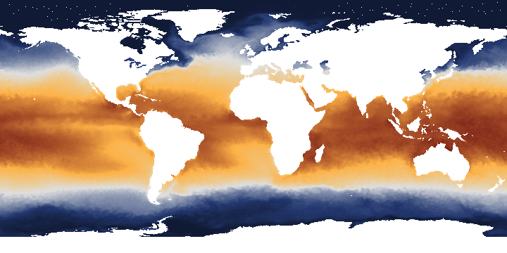
An animation made in NOAA View, a data visualization tool, showing monthly shifts in sea surface temperatures around the globe. The new Climate Data Initiative will help users create more localized maps and visuals to show climate risk.
Credit: NOAA
It launched on Wednesday with 83 federal datasets and a couple dozen tools and maps from both government and non-government sources available. Though currently limited in scope, the resources offer numerous ways to examine climate change and that make it clear it’s about more than global temperature changes. The data available show some of the other climate impacts, which include drought, heavy precipitation, heat waves, and sea level rise, all of which affect communities around the world.
The site also includes other datasets on key related issues such as population growth, social vulnerability and environmental regulations. More are expected to be added on a rolling basis.
White House science advisor John Holdren and counselor John Podesta said the data being made available were meant to address immediate as well as future vulnerabilities.RELATEDBreaking Down Key Features of Obama’s Climate Plan
NOAA’s New Cool Tool Puts Climate on View for All
Breathtaking Coral Reef Panoramas Help Scientists
“Even as we work to curb greenhouse-gas emissions and expand renewable energy generation, we need to take steps to make our communities more resilient to the climate-change impacts we can’t avoid — some of which are already well underway,” they wrote in a blog post.
Making data accessible is only part of the initiative. Usability is the more important end goal, and to do that, the White House has enlisted Google, Microsoft, mapping firm CartoDB, and a host of other private and non-profit groups to develop apps that make the risks of climate change clear. Climate Central’s Surging Seas, a tool that maps coastal flooding and sea level rise in the U.S., is part of that effort.
Google has committed more than 1,000 terabytes of cloud storage, enough space to stash over 350,000 mp3s, to house a range of observations from satellites measurements and climate models. It has also offered 50 million computing hours on Google Earth Engine, which has already drawn on satellite data to create compelling timelapses of Amazon deforestation and visuals of roadless areas around the globe. With the new partnership, Google will help provide a real-time view of drought in the U.S. as well as global water use.
In addition to harnessing big-name partners, the new initiative also looks to get web developers involved through a series of challenges to create apps that make data useable by planners and the general public. Esri, a mapping software company, issued the first challenge last week, asking developers to create a map-based app that shows climate risks. NASA and the National Oceanic Atmospheric Administration (NOAA) have also issued an app challenge to visualize coastal flood risks due to sea level rise.
Those efforts aren’t meant to supplant traditional research or the ways that NASA and NOAA already use and provide data to users. Instead, the White House said climate.data.gov is being designed to help spur innovation and partnerships outside the federal realm.
The initiative launches on a day when NOAA reported that as of February, the global average temperature has been warmer than the 20th century average for the past 29 years. That’s a clear sign of the global warming trend due in large part to manmade greenhouse gas emissions.
This isn’t the federal government’s first foray into getting climate data in the hands of the public. Other efforts include a data section on climate.gov and NOAA View, a tool that lets users quickly create maps from different climate datasets and projections. The new initiative looks to expand on those efforts as well as the proposal by NOAA’s to start a National Climate Service that was thwarted by Congress in 2010.
The new initiative is part of President Obama’s broader Climate Action Plan, which includes activities to both mitigate climate change and address its impacts. Another portion of the plan that’s tied with this initiative is a climate resilience toolkit. The kit will provide planners with tools, models, and datasets to help prepare for sea level rise, changes in extreme rainfall and temperature, and land use change.
Editor’s Note: Climate Central’s editorial staff is independent of its research team, which created the Surging Seas tool.
You May Also Like
Wood Burning for Home Heating Trendy in Northeast
CO2 on Path to Cross 400 ppm Threshold for a Month
New Greenland Ice Melt Fuels Sea Level Rise Concerns
What Winds From 20 Massive Winter Storms Look Like