
News•December 17, 2013
Toasty November Vaults 2013 Into Top 5 Warmest Years

Last month was the warmest November since record-keeping began 134 years ago, the National Oceanic and Atmospheric Administration(NOAA) reported Tuesday. The latest data, combined with more recently reported by NASA, showed a record global average surface temperature for November, particularly in Eurasia, where Russia experienced its warmest November in history.
According to NOAA, the global average surface temperature for November was 1.4°F above the long-term average for the month, and much of Russia, northwest Kazakhstan, south India, southern Madagascar, parts of the central and south Indian Ocean, and areas of the Pacific Ocean were record warm. That surpassed the previous record-holder of November 2004 by 0.05°F, and is the 6th-highest monthly departure from average of any month on record, according to NOAA.
Global average surface temperatures departures from average for November 2013, compared to the 30-year average from 1981-2010.
Credit: NOAA.
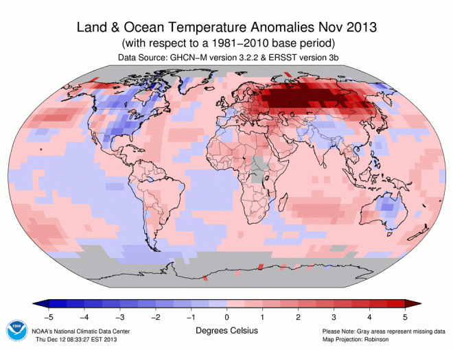
Russia had its warmest November since records began there in 1891, with some parts of the country, including Siberia and the Arctic islands in the Kara Sea, seeing temperatures that were more than 14°F above the typical monthly average.
In contrast, not a single region of the globe was record cold for the month, NOAA said. The only areas that were cooler than average were northern Australia, parts of North America, southwest Greenland, and parts of the Southern Ocean near South America.
According to NOAA, November's warmth catapulted the year-to-date to the 4th warmest year on record, up from the 7th warmest, which is where it stood as of the end of October. That puts 2013 on track to be the warmest year on record without an El Niño event, depending on where December temperatures rank.
El Niño events feature warmer-than-average ocean temperatures in the tropical Pacific Ocean and tend to alter weather patterns and ocean currents in ways that provide an added boost — on top of manmade global warming and other climate cycles — to global average surface temperatures. NOAA said that while milder-than-average global ocean conditions contributed to November's record warm, the month was the 19th straight without an El Niño or La Niña event present in the tropical Pacific Ocean.
Each of the top three years in NOAA’s dataset — 2010, 2005, and 1998, respectively — were El Niño years or exhibited the lingering effects of an El Niño.
The additional heat injected into the climate system from El Niño events accentuates the impacts of long-term global warming from manmade emissions of greenhouse gases and other causes. Although most climate outlooks show the continued absence of El Niño through the spring of 2014, should El Niño conditions develop at some point in the new year, it will increase the likelihood that 2014 will set a new global temperature record.
El Niño and La Niña events can help swing global average temperatures upward or downward with respect to their long-term average for a year or two. Typically, El Niño years are warmer than La Niña years. NOTE: This graphic uses data from NOAA, NASA GISS, and the U.K. Met Office.
Deke Arndt, chief of the climate monitoring branch of the National Climatic Data Center in Asheville, N.C., said caution is needed when comparing El Niño and non-El Niño years.
“There is no universally accepted definition of El Niño-Southern Oscillation and much less an 'El Niño year,'” Arndt said in an email.
Arndt said that from an El Niño perspective, as well as looking at how monthly global average temperatures have played out this year, 2013 more closely resembles 2005 than either 2010 or 1998.
“If you think of the annual temperature like a 12-lap race (one lap per month), 1998 and 2010 got off to big early (warm!) leads and 'hung on' in the later laps,” he said. “2005, and 2013 so far, started a bit more modestly and gained ground in the middle and late laps.”
NOAA also announced on Tuesday that the September-to-November period was the second warmest such period on record, behind only 2005. Australia had its highest average spring temperatures in its 104-year history of recordkeeping. And following its hottest month on record (January 2013), its hottest summer on record, and its 3rd-hottest winter, it is likely that 2013 will be Australia's warmest year on record.
November also brought the string of consecutive above-average months on the planet to 345, with last month being the 37th straight November with above-average temperatures compared to the 20th century average. That means that anyone younger than 28 has never experienced a colder-than-average month, globally speaking. The last below-average November global temperature was in November 1976, and the last below-average global temperature for any month was February 1985, NOAA said.
Related Content
Let it Snow, Let it Snow, Let it Snow: U.S. Sets Benchmark
Australia Has its Hottest September as Fire Threat Grows
2013 On Track to be 7th Warmest Year Since 1850
Global Warming May Worsen Effects of El Nino, La Nina Events
Global Warming, El Nino Link Stronger but Still Not Proven
This is What Global Warming Looks Like