
News•August 22, 2014
A Tale of Two Cities: Miami, New York & Life on the Edge
By Rob Motta and James White
Illustrations by Cassidy Robison
Walking along the waterfront in Fort Lauderdale and admiring the 60-foot yachts docked alongside impressive homes, it’s hard to imagine that this city could suffer the same financial fate as Detroit. But it is almost as hard to imagine how they will avoid a similar crisis given the sea level rise predicted by scientists.

The Miami-Fort Lauderdale area, with 5.6 million people, is “ground zero” in the battle against the rising seas. Perhaps nowhere else in America are the odds lined up so heavily against a region. With a relatively flat, low-lying landscape, and a porous limestone base that precludes levees, the options for this city do not look good.
A thousand miles north-east lies New York — another city very vulnerable to sea level rise. But after the wake-up call of Superstorm Sandy, Michael Bloomberg, then the mayor of New York City announced “We cannot, and will not, abandon our waterfront” and launched a $20 billion program to protect the city against the rising seas — at least for a little while. So why can’t Miami apply the same formula as New York City, and go back to relaxing on the beach? And what is this concern about sea level rise in the first place?
Most of us have heard of climate change or global warming, but what we may not realize is that about 90 percent of the heat being trapped by increasing greenhouse gases is going into the oceans, not the air. And as the oceans become warmer they expand — causing the sea level to rise. Sea level for most of the 20th century rose at the rate of about 6 inches per century. In recent years this rate has approximately doubled to a rate of just over 12 inches per century. Scientists predict that the pace will increase even more as the large ice sheets of Antarctica and Greenland begin shedding more ice to the ocean. Just how fast sea level will rise over the coming decades is undetermined at this point, but scientists agree on two points: the direction is up and the pace will increase.
But what about the costs to the nation from the encroaching seas? They, too, seem likely to rise. Precise predictions of how high sea level will rise in the coming decades are difficult to make, and as a result forecasts vary significantly. This makes it tough for urban planners who need to know what to prepare for and when those plans need to be in place.
To get a prediction his city planners could use, Bloomberg gathered a group of scientists together in 2008 to predict the local sea level rise for the coming years. Their estimates had a mid-range prediction of 11 – 24 inches by the 2050s. They did not predict beyond the 2050s, a key issue they plan to address in their next report and that we will return to later.
New York City was in the process of planning for sea level rise when Sandy hit in October 2012. If the city did not have reason to prepare for sea level rise before Sandy, it sure did afterwards. Sandy, a “1-in-70 year storm” with its 9-foot storm surge flooded 17 percent of the city, impacting 443,000 people and 88,700 buildings. It caused $19 billion in damage to the city alone. Swiss RE, a re-insurance company, estimated that if nothing is done to protect against sea level rise, a similar 1-in-70 year storm would cause $90 billion in damage to the city by the 2050s.

During tropical storms and nor’easters, storm surges pose a bigger threat than the actual sea level rise. Storm surges are caused primarily by an on-shore wind literally pushing the water towards shore. Combined with large waves from the storm, the storm surge can be the most damaging part of the storm.
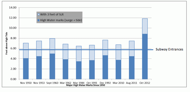
Consider the case of New York City. Subway entrances in New York are less than 6 feet above high tide. It would take a while for the seas to rise by this amount. But with Sandy’s 9-foot storm surge on top of a high tide, the entranceways to subways and tunnels were easily breached, causing extensive flooding and damage. Damage to the region’s transportation system alone topped $8 billion.
This combination of sea level rise and storm surge is the primary concern for future storms. This level of flooding in New York City may be unprecedented, but consider what a 3-foot sea level rise would do. The figure below shows that with these higher seas all major storms since 1950 would have flooded the subways.
Effect of 3 feet of Sea Level Rise on the New York City Subway System
So sea level rise is a problem by itself, but combining it with storm surge can place homes, buildings, and other infrastructure that was previously out of reach of a storm within its grasp.
After Sandy, Bloomberg stepped up efforts on climate change preparation. He pulled together a group of people and tasked them with coming up with a plan to improve the city’s resiliency to future climate change. Out of this effort came an approximately $20 billion plan to prepare New York City for the 2050s: “A Stronger, More Resilient New York”. Although some of the funds are for rebuilding after Sandy, most of the funds are for increasing the “resiliency” of the city in the face of climate change.

The plan is very comprehensive and well-developed, but perhaps the most striking aspect of it is the lack of a “silver bullet” fix for the problem. The plan discards the concept of a large (and expensive) flood wall to protect large portions of the city, citing the many problems that this sort of a solution entails — very large costs with associated funding problems, potential cost and schedule overruns, unforeseen environmental consequences, and the worst fear of all - that the city will bank everything on this solution only to run into financial, legal, or technical problems years or decades down the road — leaving them high and not so dry.
What the plan does do is propose a wide array of solutions — 257 initiatives in all. That way they can make incremental gains and move ahead as they have funding, rather than betting everything on a single solution.
To develop their plan they divided the coastline into separate areas with different topographic features and looked at what solutions each one would need, such as sand dunes vs. floodwalls. They contracted with Swiss RE to use their computer models to analyze the impacts of storms as sea levels rise, the damage that would occur, and possible mitigating strategies. The re-insurance companies have a lot to lose with big natural disasters and climate change, so they have sophisticated models to analyze such events.

The New York City team looked separately at all the areas that might be impacted — buildings, infrastructure, utilities, telecommunications, transportation, health care, and wastewater treatment. For example, 53 percent of the generating capacity that is located in the city is now in the 100-year floodplain, but this will rise to 97 percent by the 2050s. They then looked at what measures could be taken to protect the facilities, or provide alternate sources of power during emergencies, and what regulatory measures would be needed to make this happen.
For buildings, they looked at what could be done to make the buildings more “resilient.” For example, changing building codes to require more “freeboard,” defined as the extra height above the projected 100-year flood level that key infrastructure like electrical and telecommunications equipment is placed at.
The New York City plan appears to be a well thought-out, comprehensive one. So everything is OK and we can relax, right? Not so fast. First, the $20 billion does not cover all of the planned work to protect the city for the 2050s. It only covers the “Phase 1” work, which is expected to take the first 10 years, and at last update they were short $4.5 billion in funding. In addition, cost estimates were still being developed for Phase 2, and then the funding will have to be found for that.
A more long-term problem is that the plan only looks at the sea level rise through the 2050s. But the sea will continue to rise beyond the 2050s, and likely at a faster rate than it did between now and then. The Earth tells us from past warm periods that we can expect 5 to 10 feet of sea level rise for a each 1˚F of warming. Considering that the current limit for “dangerous” climate change is considered by the U.N. and many nations to be 2˚C or about 3.5 ˚F, which translates into something like 15 to 35 feet of sea level rise, and it would seem that New Yorkers may need to grow gills if they are to stay on the current waterfront as the decades and centuries pass.
Clearly, as sea levels rise, it will become harder and harder to protect key assets. So where is the plan for 2100 or 2150? Most likely the cost to protect the city for the next 50 years beyond the 2050s will be much, much higher than to protect it to the 2050s. And it is hard to shake the uneasy feeling that New York may be fighting a hopeless battle, spending billions on a battle that absent any action soon on greenhouse gases and climate change, seems unwinnable.
So while the NYC plan is certainly laudable, it is important to realize that it does not even contain 100 percent of the funding to take them to the 2050s, let alone look beyond that to 2100. But alas, 2100 is more than 20 election cycles away. When Bloomberg said, “We cannot, and will not, abandon our waterfront,” was he being realistic, or was it just political bravado? Perhaps his grandchildren will find out.

The Miami metropolitan area also faces the challenge of rising seas, but with a number of interesting differences both physically and politically. Most of the area is within a few feet of sea level, meaning it will not take much of a storm surge to flood the city. Even now, when a high tide hits, water bubbles up through the grates in the streets and floods parts of Miami and Fort Lauderdale.
The area also relies on the Biscayne aquifer for much of its water supply, and as sea level rises the fresh-salt water interface is moving inland — meaning wells that are close to the coast must be abandoned and moved inland to continue to get fresh water. This can only go on for so long before securing enough fresh water from underground sources becomes a problem.
But perhaps the biggest issue for the area is that the land is made up primarily of porous limestone through which groundwater moves easily, which means that levees are not a viable option — water will simply go underneath. So if levees won’t work, what are the other options?
There are typically three responses for rising sea levels: protection, adaptation, or retreat. Protection means building structures like levees to protect what is behind. Adaptation means taking measures like raising the existing buildings, or maybe just raising key equipment inside a building, like the electrical and communications utilities, so that the buildings can withstand occasional floods with minor damage.
Last, you can retreat. That means picking up and moving to higher ground.
Southern Florida Plans for the Future:
Sea Level Rise Plus 3 Million More People

Four counties in South Florida, with a combined population of 5.6 million residents, formed a Climate Change Compact to work on the problem together. Like New York City, they developed their own sea level rise projections based on relevant scientific literature and unique local conditions, and came up with projections very close to New York City’s: 9 – 24 inches by the year 2060. They then developed inundation maps to see where this water level would reach, and are taking the projected sea level rise into account in their capital plans.
But in many respects they are far behind New York City in preparation. They have not yet looked at storm surge on top of the static sea level rise, a substantial omission as hurricanes and tropical storms are more frequent in Florida than in New York. And they have not developed detailed impact analyses of what will be affected at each increment of sea level rise, or with various levels of storms, like New York City did with the Swiss RE models.
Even more basic, the area seems to be sending conflicting messages as to whether they are taking the issue seriously. At the same time that the four counties are projecting a sea level rise of 9–24 inches, another working group of the original four counties, plus three more, are projecting a 50 percent population growth by 2060. The two projections seem irreconcilable.
So what can the people of South Florida do? If protection is not viable because of the porous ground, that leaves adaptation or retreat. Adaptation may work for a while, but ultimately it is hard to imagine high-rise buildings with water lapping at their bases.
That leaves retreat. Many people think that a relocation of people is the only viable option for South Florida. And if that retreat is not carefully managed, then the hit to the area’s economy and tax base could be substantial. The four counties project a loss of up to $4 billion in taxable real estate with a 1-foot rise in sea level, and as much as $30 billion with 3 feet. Some say that articles like this cause panic, but it is precisely the opposite that will cause panic — not openly discussing the issues and the various sea level rise scenarios, and what to do in each case.

Let’s take a possible scenario as to what might happen in South Florida. According to Renaissance RE, another re-insurance company, the average Florida house’s mortgage is subsidized to the tune of $72,000 – by the National Flood Insurance Program as well as Florida’s state-run Citizens Insurance program. Two changes are possible or likely in the insurance market. Typically, the federal flood insurance program subsidizes insurance for private homes up to a value of $250,000 as well as small businesses. Private companies insure home values above $250,000 and large commercial enterprises.
Two storm clouds are brewing on the horizon. First, in response to the federal flood insurance program racking up a debt of $24 billion, Congress recently passed two acts designed to try and financially stabilize the program. The exact implementation of the laws is still being worked out, but some properties will see increases in insurance rates up to 18 percent per year until non-subsidized rates are achieved.
Secondly, the insurance companies have traditionally determined rates based on actuarial data. In other words they look back at past costs to determine future rates. That of course assumes that future conditions will be similar to past conditions. With sea level rise that is not the case, and insurance companies may have to start charging premiums based on predicted future losses.
The first of these factors is already in place and the second at this time is speculative. In any case, insurance rates could have a dramatic impact on costs to own a coastal home. Combine that with damage from a major storm and suddenly the cost of owning near the ocean could be prohibitively expensive. Some speculate that there will be a gradual decline in property values along the coast as the sea level rises. Others believe that there could be a more precipitous drop — perhaps initiated by a hurricane or storm like Sandy where people decide to just walk away from what is left of their home, or are effectively forced to do so because they cannot get insurance.
But sea level rise will not end in the year 2050, or even 2100. Perhaps even more important than any single prediction for the next 50 to 100 years is to think of sea level as rising for a long, long time. Tad Pfeffer, one of the authors of the latest Intergovernmental Panel on Climate Change (IPCC) report looks at it this way: “On the timescale of any meaningful planning effort, sea level will never stabilize. In human terms, it will essentially keep rising forever.” That is because there is a very large amount of sea level rise currently “stored” as ice all over the world – more than 200 feet. While nobody is suggesting that this will all melt soon, the facts are that the Earth is warming, and heat makes ice melt. Sea level is rising now, and when the retreat begins in the Miami area, perhaps the most important question will be “where is the safe ground?” Scientists will be hard pressed to answer that question, and the odds seem good that South Florida will not like the answer.
The last time that carbon dioxide concentrations in the atmosphere were as high as they are today, about 3 million years ago, sea level is estimated to have been about 65 feet higher! That means that if we stopped all emissions at this instant, and waited hundreds of years, sea levels would stabilize at about 65 feet higher than today. That is a long way off, but the problem is that nobody really knows exactly what the curve looks like between here and there. Will most of the sea level increase occur earlier or later in this timeframe, or will it be equally spread out? Will there be abrupt “step-changes” along the way?

That is exactly what James White’s team looked at for the National Academy of Sciences in a recent report on what is called “abrupt climate change.” There is evidence that at times in the past when the world changed from ice ages to post-ice ages the sea level increased by a foot or more per decade. These abrupt shifts in sea level would severely challenge our ability to adapt.
The problem of sea level rise is indeed a very large problem. Within the U.S., about 5 million people live within 4 feet of high tide. And it is not just houses that are at risk. A large part of our nation’s infrastructure is located very close to the sea. Wastewater treatment plants are normally located at a low point in the city and are often at or close to sea level. Power plants are often located in low-lying areas.
A good example of the difficulty that lies ahead is the numerous military bases that are located at or near sea level. Joe Bouchard, retired Commander Officer of Naval Station Norfolk, the largest naval base in the world, said at a recent conference in Florida that 128 U.S. military bases could be impacted by a 3-foot sea level rise. Naval Station Norfolk has already spent $240 million to build 4 new piers to replace older ones that were affected by past sea level rise, so what will it cost to upgrade all 128 bases? We don’t know what the total cost will be, but we can probably conclude it will not be cheap!
And that is perhaps one of the biggest concerns with sea level rise – how little the potential economic, environmental and other impacts have been analyzed and quantified. How much will it cost us if the sea level rises 3 feet by the year 2100? Nobody really knows. Cities are starting to analyze the impacts, but a lot remains to be done. And then there are the small towns and villages that have limited resources to analyze this sort of impact. What’s the total impact? Nobody knows. That’s scary.

It is obvious why someone in New York or Miami should care about sea level rise, but other than the impact on Federal facilities like the military bases, why should someone in Kansas or Colorado care about the costs of sea level rise? Isn’t this their problem? That may be true, but the total damage from Sandy to New York and the surrounding area resulted in a $61 billion federal aid package that was everyone’s money. Given that costs of sea level rise are already high and are likely to keep rising in the future with no end in sight, whether all taxpayers should continue to foot the bill for damage to coastal communities, or even for actions to mitigate future damage, is sure to be a hot button issue in the future.
So what can we conclude from all of this? We need to start planning and implementing now. A simplistic cookie cutter solution of building levees may work in some places, but certainly not all. Our understanding of how to tackle storm surges and sea level rise has evolved over time to perhaps a more sophisticated view — that multiple approaches may be better than the “big gun” approach. We can also use nature’s tidal areas, sand dunes, and wetlands to dull the impact of storms. What seems clear is that each area needs to evaluate what will work best for itself. And if we start acting now, we might just be able to avoid another Detroit.
Jim White is the Director of the Institute of Arctic and Alpine Research (INSTAAR) and a Professor of Environmental Studies at the University of Colorado; Rob Motta is an affiliate at INSTAAR; Cassidy Robison is an artist and student in the Department of Art & Art History, University of Colorado Boulder.