
News•October 17, 2014
Picture This: Seasonal Rainbows & A Monster Hurricane
The big news in weather this week was the sudden surge of storm activity in the Atlantic Ocean (not to mention a fairly rare tropical storm heading Hawaii’s way). The star of the cyclone show has been Hurricane Gonzalo, the first Category 4 hurricane in the Atlantic basin since 2011. But there was, of course ,weather news outside of the tropics, from fall tornadoes in the U.S. to a stunning lightning show over Mexico filmed from space.
Gonzo Gonzalo
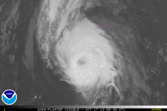
The arrival of a strong phase of a climate pattern called the Madden-Julian Oscillation set off a flurry of storm activity in what has otherwise been a quiet ocean basin for most of the Atlantic Hurricane Season. While Tropical Storm Fay briefly achieved hurricane status, the storm behind it, Gonzalo, grew into a monster, presenting an imposing scene from space.
#Hurricane#Gonzalo over the Caribbean Sea pic.twitter.com/4ufDIiAA61
— Alexander Gerst (@Astro_Alex) October 17, 2014
Gonzalo reached Category 4 hurricane strength late Wednesday morning — the first hurricane to do so since Ophelia in 2011. Gonzalo reached the point where it was the strongest storm in the basin since 2010’s Hurricane Igor.
The hurricane has since weakened slightly, though it is still expected to be a major hurricane (Category 3 or higher) when it hits Bermuda.
Incredible high resolution satellite imagery of Hurricane Gonzalo this afternoon, via VIIRS I Band satellite. pic.twitter.com/9EgHLSCzf6
— NY Metro Weather (@nymetrowx) October 17, 2014
The last big hurricane to hit the island was Hurricane Fabian in 2003, which did considerable damage, as Adam Mersereau wrote on Gawker’s The Vane blog.
The image from the Weather Channel's Twitter account showed just how dwarfed the tiny island is by Gonzalo.
Large IR satellite image of #Gonzalo. We point out Bermuda. Live Updates: http://t.co/TScveAVV9wpic.twitter.com/CIOuONTQD9
— The Weather Channel (@weatherchannel) October 17, 2014
As did NOAA:
And as the hurricane approached the island on Friday, its eye became visible on the local radar.
Eye of Cat 3 Hurr #Gonzalo now showing up in Bermuda radar. Direct hit likely later today. http://t.co/4XK34PbBtApic.twitter.com/4FfoD3gz0y
— Eric Holthaus (@EricHolthaus) October 17, 2014
Lightning-Studded Flyby
Astronaut Reid Wiseman certainly has a knack for creating awesome Vines of weather from space. In one of his latest, he captured a storm over Mexico popping off bursts of lightning.
Cold Front Shadow
The tropics weren’t the only spot where the weather ramped up this week. A cold front worked its way across the U.S., spawning tornadoes and bringing heavy rains that caused flash flooding in some areas.
The rising sun made for a very cool looking shadow as a cold front moved toward our area. Clearing this afternoon. pic.twitter.com/v7SfUAf0g7
— NY Metro Weather (@nymetrowx) October 16, 2014
A satellite happened to catch a particularly cool image of the front when the angle of the sun at sunrise cast a shadow across the storm front. According to the folks at New York Metro Weather, the shadow comes from higher clouds and is projected onto lower-lying clouds. Such shadows can particularly happen when there’s a sharp moisture difference across the front.
Seasonal rainbow
We’ve featured our fair share of rainbow photos in this space, but we couldn’t pass up this gorgeous shot:
Awesome work Alan Johnson. Yesterday Linn Cove and Rough Ridge area. Enjoy! I just happene… http://t.co/MsOB01XOwbpic.twitter.com/V4BaAvWSQu
— Brad Panovich (@wxbrad) October 12, 2014
Rainbows: Now with fall leaves!