
News•November 6, 2014
An Inside Look at How Monster Tornadoes Can Form

By Brian Kahn
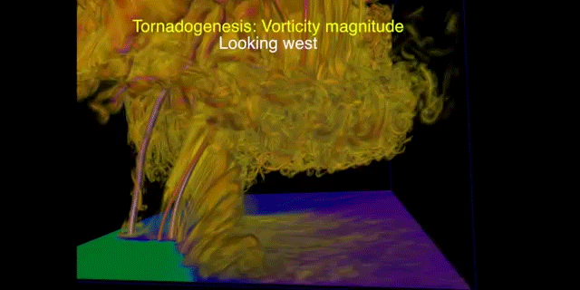
Ever wondered what it would look like if 90s blockbusters “Twister” and “The Matrix” were mashed up? OK probably not, but if it did happen, this 3-D model of a tornado is a likely candidate.
An animation showing modeled winds during a May 2011 tornado. Credit: Leigh Orf
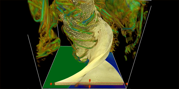
Leigh Orf, a meteorologist at Central Michigan University, presented a model simulation of a what can cause and sustain a violent EF-5 tornado — the most damaging type of tornado that can form — at the Severe Local Storms Conference this week. The visuals show that while we often think of the atmosphere as air, it actually behaves and looks a lot like liquid.
The real-world inspiration for the video was an EF-5 tornado that formed in Oklahoma during a major tornado outbreak in late May 2011. That outbreak spawned 241 tornadoes, including the deadly twister that devastated Joplin, Mo. However, the storm that was modeled was another EF-5 tornado that touched down on May 24 and tore across a nearly 65-mile stretch to the west and north of Oklahoma City.
Mobile radar equipment measured winds of at least 210 mph and a local ground station recorded a wind gust of 151 mph, the strongest wind recorded by Oklahoma’s weather monitoring system. The tornado killed nine and left 181 injured while also tearing houses from their foundations, bending metal poles like stalks of corn, and destroying a nearly 2-million pound oil rig.
Some research has suggested that climate change could be shifting tornado habits in the U.S. by making big outbreaks like the one that spawned this tornado more common even as there are fewer overall tornado days.

The destruction wrought by this and other tornadoes leaves indelible marks on communities in their path. The images of the aftermath also shape our perceptions of severe weather.
But understanding the inner workings of storms and how they form are also vitally important to scientists and can help improve severe weather warnings.
Dennis Mersereau of The Vane sums it up this way:
The video is a testament to the incredible computer powers available to scientists today that allow us to see the mechanics of tornadoes. Hopefully this research will lead to a better understanding of how tornadoes form and strengthen, ultimately leading to better warning times.
You May Also Like:
Voters Weigh In on Fracking, Water Measures
2014 Will Go Down As Hottest In California’s History
UN Climate Report Rings Alarm, Offers Guidance
New Jersey Retreating from Rivers, But Not Coast, After Sandy