
News•July 10, 2015
Japan's New Satellite Tracks Typhoons, Imitates Art

By Brian Kahn
It's a good week to start a job if you're a weather satellite. With three typhoons churning in the western Pacific, there's no shortage of interesting things to look at and analyze.
So it's safe to say that the Japan Meteorological Agency's new Himawari-8 satellite has been kept busy since going operational on Tuesday. The satellite is in orbit about 22,000 miles above the Earth's surface, taking a fresh picture every 10 minutes. It's geostationary, meaning it stays in orbit directly above a portion of the Earth. In Himawari-8's case, that position is right over the Pacific Ocean where all the tropical fireworks are currently taking place.
The 16 channels of light wavelengths that Japan's Himawari-8 satellite is capable of observing.
Credit: CIMSS.
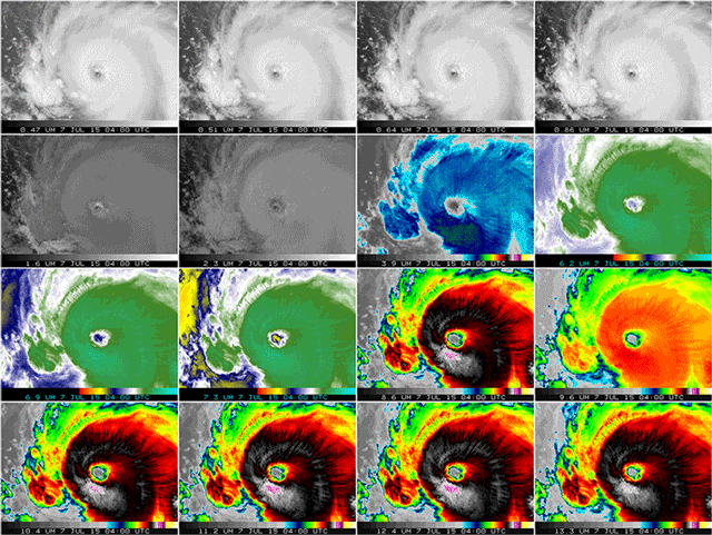
The satellite cost Japan an estimated $692 million and its already proving its worth by capturing highly detailed images of the typhoons churning in the western Pacific. The images come in 16 light wavelength flavors and are highly detailed with resolution down to three-tenths of a mile. That's essentially double the resolution of similar satellites.
The Cooperative Institute for Meteorological Satellite Studies has an image of all the different wavelengths Himawari-8 is capable of seeing that would make Andy Warhol proud. The New York Times also has some stunning animations that put the high resolution nature of Himawari-8 on display. (Seriously. Do yourself a favor and go look at them on a big screen.)
But Japan didn't invest $692 million just for making planetary art. The detailed imagery provides scientists with more data that can help improve weather forecasts. In the case of typhoons and other tropical storms, satellite data could translate to more accurate storm tracks and intensity forecasts for when they make landfall.
And the timing for Himawari-8 to come online couldn't be better. Typhoon Chan-hom is forecast to make landfall within 24 hours in or around Shanghai. Though the storm is forecast to weaken to a Category 1 with winds around 90 mph at landfall, it could bring some of the worst flooding the region has seen in decades and would be one of only a handful of typhoons on record to strike China's largest city. At Wunderground, Jeff Masters notes that the storm may produce an extremely powerful storm surge that could challenge records set by Typhoon Winnie in 1997.
Himawari-8 will be in a perfect place to observe Chan-hom as well as the next storm in the line, Typhoon Nangka, which could threaten Japan by the middle of next week.
Not wanting to be left out, NASA and the National Oceanic and Atmospheric Administration plan to launch a similar satellite, GOES-R, next March.
You May Also Like:
How 2°C of Warming Could Reshape the U.S.
Coastal Nations, Megacities Face 20 Feet of Sea Rise
Sharks Face a Growing Threat in Warming and Acidic Seas