
News•March 11, 2016
The Fuel Behind Louisiana’s Torrential Rains, Floods
Neighborhoods have been turned into lakes and roads into streams as record-breaking rain has fallen relentlessly on Louisiana and other parts of the Gulf Coast this week. The deadly flooding and eye-popping rainfall amounts — reaching above 21 inches in the worst hit areas — came courtesy of a slow-moving system pulling abundant moisture from the tropics.
A car lies submerged in the Tall Timbers subdivision after flooding near Shreveport, La., March 9, 2016, in a photo provided by the Bossier Parish Sheriff's Office.
Credit: REUTERS/Deputy Josh Cagle/Bossier Parish Sheriff's Office via Reuters

Such heavy downpours are expected to happen more often and be more intense as the world heats up due to the increase of greenhouse gases in the atmosphere. In fact, such an increase has already been observed in the U.S.
Just what role climate change may have played in this particular rain event would take a dedicated study to determine, but experts said that the atmospheric setup has likely been influenced by the strong El Niño that has affected weather around the world.
The excessive rain began Tuesday as the result of an unusual area of low pressure over Mexico with an area of abundant moisture on its eastern flank. The system has progressed eastward slowly, “so the area of rainfall has persisted over the same area,” Bob Oraveck, a lead forecaster with National Weather Service's Weather Prediction Center, said.
RELATEDAcross U.S., Heaviest Downpours On The Rise
Warming Brings Increasing Flood Risk And Heavier Rain
Extreme UK Rains More Likely With Warming
The worst hit area has been northwestern Louisiana, where some spots have measured more than 21 inches of rain in a matter of days. There is a widespread area from eastern Texas to southern Arkansas and into Mississippi that will likely see at least 10 inches, Oraveck said.
The system is pulling moisture from the Gulf of Mexico — reaching down to the Yucatan Peninsula — along what is called an atmospheric river. Such narrow streams of moisture in the atmosphere are more commonly associated with the West Coast.
The atmospheric river associated with this storm has been called a Maya Express, a reference to its roots in Mexico and to the Pineapple Express events that bring the West Coast some of its most drenching storms.
The track of this storm fits with the general pattern seen during El Niño winters, as they tend to move further south than they otherwise would thanks to a southward dip in the subtropical jet stream. That same pattern has led to an unusually wet winter weather in Florida — the southern tip of the state had its wettest winter ever — and fueled an unusually high number of tornadoes there.
Ocean waters in the eastern Pacific Ocean have also been higher because of El Niño, which has also helped the storm pull in more moisture, Ken Kunkel, a climate scientist with the National Centers for Environmental Information, said in an email.
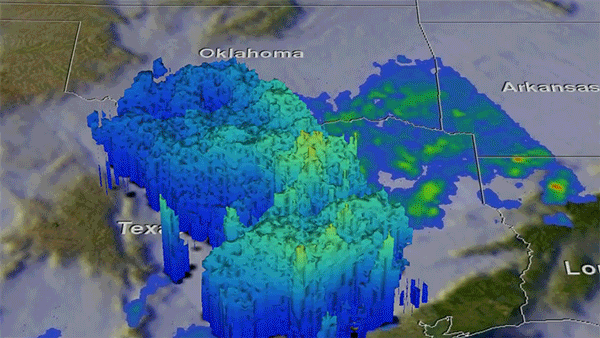
Animation rains measured by NASA's Global Precipitation Measurement satellite.
Credit: NASA/JAXA/SSAI, Hal Pierce.
Kunkel and atmospheric scientist Cliff Mass, of the University of Washington, both said that it is possible that global warming affected this rain event to some degree, though it would take a dedicated study to pinpoint the exact increase in the risk of such an event due to climate change.
A new report released Friday by the National Academy of Sciences has found that such extreme event attribution studies can be done reliably for certain types of weather extremes, including heavy precipitation. Studies by Climate Central and other groups have shown an increase in the odds of some precipitation events from warming.
Mass has done work that suggests atmospheric rivers, at least along the West Coast, should become more intense in the future with warming, but that the effect today is still small.
In general, climate scientists expect heavy downpours to increase over the U.S. and elsewhere, as a warmer atmosphere can hold more moisture, making more of it available to fall as rain. Observations have already shown an increase, though the amount varies from region to region.
The Southeast as a whole has seen a 27 percent increase in the amount of rain falling in the heaviest events since 1958. Baton Rouge ranks among the top 20 cities in terms of the increase in heavy downpours it has seen, with a 120 percent increase since the 1950s, according to a Climate Central analysis.
This particular event is expected to wind down as the system moves eastward and picks up speed, Oraveck said, with the rain tapering off this weekend.
Another system is making its way eastward, but any rain from it should be “nothing like what we’ve had,” Oraveck said.
You May Also Like:
U.S., Canada Pact Targets Lesser Known Climate Impacts
Scientists Trace Climate-Heat Link Back to 1930s