
Climate Matters•April 26, 2023•Reuse this content
Rising Hourly Rainfall Intensity
KEY CONCEPTS
Climate change is supercharging the water cycle, bringing heavier rainfall extremes—and related flood risks—across the U.S.
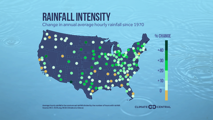
136 of 150 U.S. locations analyzed by Climate Central have experienced increasing hourly rainfall intensity since 1970.
Rainfall hours became 13% wetter on average across all 150 stations from 1970 to 2022.
Hourly rainfall intensity has increased in every U.S. region, with the largest increases in the Central and Southwest regions.
People, ecosystems, and infrastructure in both wet and dry locations are facing the risks that come with short bursts of extreme rainfall.
Learn more in Climate Central’s Wetter Rainfall Hours in a Warming Climate report.

Climate change is supercharging the water cycle, leading to heavier rainfall extremes across the U.S.
Heavy downpours bring more rain, faster—causing flash flooding and landslides that can displace families, drown crops, damage infrastructure, and expose people to hazardous debris, contaminants, and water-borne disease.
These events are especially hazardous because their rapid onset limits time to issue warnings and get people out of harm’s way.
These risky rainfall extremes are the focus of a new Climate Central analysis.
Hourly rainfall intensity
Climate Central calculated the Simple Hourly Rainfall Intensity Index (total annual rainfall divided by the total annual hours with rainfall) for 150 U.S. weather stations with sufficient data quality over the 1970-2022 period.
An increase in the Simple Hourly Rainfall Intensity Index indicates an increase in hourly rainfall intensity—in other words, more rain falling per hour.
The Simple Hourly Rainfall Intensity Index is the average rainfall intensity (inches per hour) but only for days when it rains. This means that it can show increasing hourly rainfall intensity even if the total amount of annual rainfall is decreasing.
More rain per hour in most places
136 (91%) of the 150 stations analyzed had an increase in hourly rainfall intensity since 1970.
The average change in the Simple Hourly Rainfall Intensity Index across all 150 locations from 1970 to 2022 was +13%.
Increases in hourly rainfall intensity since 1970 were observed across all nine U.S. regions analyzed.
The largest average increase in hourly rainfall intensity was in: East North Central (+19%); West North Central (+18%); Central (+16%); Southwest (+14%); and Northeast (+13%).
61% (91/150) of stations had an increase in hourly rainfall intensity of +10% or more.
Check out NOAA’s Rain Rate Visualizer for videos of various hourly rainfall rates.
For example: 0.25, 0.5, 0.75, 1.0, and 1.5 inches per hour.
Top 10 increases in hourly rainfall intensity
| Location | Change in Simple Hourly Rainfall Intensity Index (1970-2022) |
|---|---|
| Fairbanks, Alaska | 44% |
| El Paso, Texas | 41% |
| Wichita Area, Kan. | 39% |
| Reno, Nev. | 37% |
| Rapid City, S.D. | 35% |
| Bismarck, N.D. | 31% |
| Binghamton, N.Y. | 29% |
| Huntington, W.Va | 28% |
| Pittsburgh, Pa | 28% |
| Sioux Falls, S.D. | 28% |
Rainfall extremes increasing—even in dry places
The 10 locations with the greatest increase in hourly rainfall intensity span a wide range of mean annual precipitation, and all but three (Binghamton, N.Y., Huntington, W.Va., and Pittsburgh, Pa.) are below the national average (31.3 inches for the 1991–2020 normal).
This underscores that the increase in hourly heavy rainfall intensity is widespread and that the risks posed by short bursts of extreme rainfall are relevant for both wet and dry locations. And places with high total annual rainfall don’t necessarily have the largest increases in the intensity of rainfall events.
This finding is consistent with the latest reports from the Intergovernmental Panel on Climate Change indicating that precipitation extremes are likely to increase nearly everywhere, even in regions with decreasing average precipitation.

Rainfall extremes in our warming climate
For every 1°F of warming, the air can hold an extra 4% of moisture.
This relationship between air temperature and water vapor pressure is governed by the laws of thermodynamics and represented in the Clausius-Clapeyron equation.
The U.S. has already warmed approximately 2.5°F since 1970—meaning our atmosphere can already hold about 10% more moisture.
More moisture in warmer air increases the chances that rain falls in heavier downpours.
Theory suggests that rainfall becomes more intense with warming. And both rain gauge data and modeling experiments support this theory.
Globally, the frequency and intensity of heavy rainfall events have increased since the 1950s, largely due to human-caused climate change, according to the latest reports from the Intergovernmental Panel on Climate Change.
In the U.S., extreme daily rainfall events have been on the rise since the 1980s. From 1958 to 2016, the heaviest 1% of rainfall events became 55% and 42% wetter in the Northeast and Midwest, respectively—and 9–29% wetter for all other regions of the contiguous U.S. and Alaska.
Intensifying rainfall has been affecting Americans for more than three decades. Historical rainfall trends across the U.S. from 1988 to 2017 accounted for one-third of nationwide flood damages (about $73 billion) over that same period. And the most intense downpours caused the largest damages.
LOCAL STORY ANGLES
How vulnerable is your area to flooding?
Factors like local topography, age of infrastructure, watershed health, and precipitation trends influence flood vulnerability. See current flood risks in your neighborhood with FloodFactor’s zipcode-level risk identifier. A 2021 report found that one-fourth of critical infrastructure is put at risk of failure by flooding. The American Society of Civil Engineers grades the integrity of infrastructures by state and category.
Who is most vulnerable to heavy rain-related hazards?
Racial minorities and mobile homes are disproportionately exposed to flooding, especially in rural areas and in the southern U.S. The American Flood Coalition has resources on adaptation, equitable disaster recovery, and funding opportunities for flood-resilient communities. On March 22, the U.S. Department of Housing and Urban Development (HUD) announced nearly $3 billion in funding to aid in disaster recovery.
What can you do to protect against flooding and extreme precipitation?
Firstly, know your own risk using the Federal Emergency Management Agency’s flood maps. Individual homeowners can insure their homes, maintain rainwater systems, reduce impervious surfaces on their property, elevate important utilities and equipment, and take on low-cost indoor projects recommended by FEMA. Communities can invest in flood management systems, green infrastructure and watershed restoration.
CONTACT EXPERTS
Felipe Quintero Duque, PhD
Assistant Research Scientist
University of Iowa
Related expertise: rainfall and flood forecasting
Contact: felipe-quintero@uiowa.edu
*Available for interviews in Spanish and English
Gabriel J Perez Mesa, PhD
Postdoctoral Research Associate
Oak Ridge National Laboratory
Related expertise: hydroclimate extremes, flood frequency analysis
Contact: perezmesagj@ornl.gov
*Available for interviews in Spanish and English
Erin Dougherty, PhD (she/her)
Project Scientist I
National Center for Atmospheric Research
Related expertise: precipitation and hydrologic extremes in a warming climate
Contact: doughert@ucar.edu
Daniel Wright, PhD (he/him/his)
Associate Professor
University of Wisconsin-Madison
Related expertise: Rainfall and flooding at urban scales
Contact: danielb.wright@wisc.edu
FIND EXPERTS
Submit a request to SciLine from the American Association for the Advancement of Science or to the Climate Data Concierge from Columbia University. These free services rapidly connect journalists to relevant scientific experts.
Browse maps of climate experts and services at regional NOAA, USDA, and Department of the Interior offices.
Explore databases such as 500 Women Scientists, BIPOC Climate and Energy Justice PhDs, and Diverse Sources to find and amplify diverse expert voices.
Reach out to your State Climate Office or the nearest Land-Grant University to connect with scientists, educators, and extension staff in your local area.
METHODOLOGY
The calculation of the Simple Hourly Rainfall Intensity Index is the total annual rainfall divided by the total number of hours with rainfall in a year. This is an extension of one of the core climate indices defined by the Expert Team on Climate Change Detection and Indices, the Simple Precipitation Intensity (SDII), modified to evaluate per hour rather than per day. For the detailed methodology, please refer to Climate Central’s Wetter Rainfall Hours in a Warming Climate report.
Climate Matters © 2023 by Climate Central is licensed under CC BY 4.0
This license grants permission to use, distribute, and reproduce all text, graphics, and multimedia content published on this page in any medium, provided that Climate Central is credited per the CC BY 4.0 license.
Permission to use data and other materials published on this page is granted for non-commercial uses, commercial news purposes, and educational purposes as governed by Climate Central's Terms of Use.