
Climate Matters•July 5, 2023•Reuse this content
More Extremely Hot Days
KEY CONCEPTS
The frequency of extremely hot days has increased since 1970 in 195 U.S. locations analyzed by Climate Central.
About 71% (139) of these locations now experience at least 7 additional extremely hot days each year than in 1970.
Extremely hot days increase the risk of heat-related illnesses and hospitalizations.
Climate Central’s Climate Shift Index tool, now available in KML format, quantifies the influence of human-caused climate change on daily temperatures.

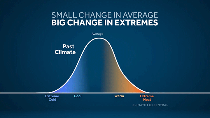
Extreme temperature shift
In 2022, the average global temperature was 2°F warmer than the 1881–1910 baseline. Relatively small increases in average temperatures cause relatively large increases in extreme temperatures.
Heat is the leading cause of weather-related fatalities in the U.S. Climate change is making bouts of extreme heat more frequent and intense.
As carbon pollution traps more heat in Earth’s atmosphere, the summer season is warming, summer temperatures are arriving earlier in the year, and risky heat occurs more often.
More frequent extremely hot days
A new Climate Central analysis looks at the changing annual frequency of extremely hot days in 247 U.S. locations during recent decades of warming.
This analysis defines an extremely hot day as exceeding the 95th percentile of that location’s average maximum summer temperature rounded up to the nearest 5°F (see Methodology).
The extremely hot day temperature threshold ranges across the locations analyzed—from 70°F in Juneau, Alaska to 110°F in Phoenix, Ariz.
The extremely hot days threshold reflects the hottest temperatures of summer, and this analysis tallies the year round number of days above this threshold. As average temperatures rise and heat extremes occur more often, many places experience summer-like temperatures outside the summer season.
Results of the analysis summarized below are based on 241 locations (see Methodology).
The annual number of extremely hot days increased from 1970 to 2022 in 195 (81% of 241) locations analyzed.
The average change across these 195 locations was 11 more extremely hot days now than in 1970.
Nearly one-third (62) of these locations now experience at least 14 additional extremely hot days each year than in 1970.
Three locations now experience at least 30 additional extremely hot days each year than in 1970:
Austin, Texas: 47 more extremely hot days (above 100°F) annually
San Angelo, Texas: 39 more extremely hot days (above 100°F) annually
Montgomery, Ala.: 31 more extremely hot days (above 95°F) annually
Fingerprints of climate change on extremely hot days
Climate Central’s Climate Shift Index tool quantifies the influence of human-caused climate change on daily temperatures.
Now available in KML format, the Climate Shift Index uses the latest climate change attribution science to put a number on whether and to what extent carbon pollution made daily average and extreme temperatures more likely.
Extreme heat is a health hazard
More frequent extreme heat is not only an indicator of climate change—it’s also one of the most serious health risks in our warming climate.
Heat is the leading cause of weather-related deaths in the U.S. Exposure to extreme heat makes it difficult for our bodies to cool off, resulting in heat-related illnesses including heat cramps, heat exhaustion, and even fatal medical emergencies such as heat stroke.
Summer heat can also worsen air quality by trapping harmful pollutants in the air we breathe. These pollutants can exacerbate respiratory health issues in people with asthma and other lung diseases.
And as our climate warms, risky heat arrives earlier and lingers later. A recent Climate Central analysis found that 232 U.S. locations have seen the year-round frequency of risky heat days increase—by 21 more days on average since 1970.
Heat risks unequally shared
Extreme heat can affect everyone, but some face greater risks of heat-related illness and mortality than others.
Children, adults over 65, pregnant people, and people living with illness are particularly vulnerable to heat-related illness.
Outdoor workers and athletes are also at elevated risk due to work- and recreation-related exposure to extreme heat.
Structural inequities can also lead to higher extreme heat exposure in some communities. According to a recent study, people of color and people living below the poverty line are disproportionately exposed to urban heat island intensity in 169 of the largest U.S. cities.
LOCAL STORY ANGLES
How is extreme heat affecting public health near you?
The Centers for Disease Control and Prevention Heat and Health Tracker maps heat-related illnesses at the census-tract level in real time. Use the National Integrated Heat Health Information System (NIHHIS) Heat Equity Mapper to find census tracts in your area with the highest heat burden. Check the U.S. Department of Health and Human Services monthly Climate and Health Outlook for extreme heat outlooks in your region throughout the summer.
How are local officials protecting people from extreme heat?
Reports from NOAA’s urban heat island mapping campaigns cover local risk reduction and adaptation strategies in 60+ U.S. cities. The NIHHIS provides heat preparedness and planning resources. Find your state's emergency management agency to learn more about heat action plans in your area. Check with local officials for available cooling centers. The Low Income Home Energy Assistance Program (LIHEAP) aims to alleviate extreme heat stress for vulnerable populations. Explore LIHEAP data and mapping tools to see how and where historical funding has been allocated.
FIND EXPERTS
Submit a request to SciLine from the American Association for the Advancement of Science or to the Climate Data Concierge from Columbia University. These free services rapidly connect journalists to relevant scientific experts.
Browse maps of climate experts and services at regional NOAA, USDA, and Department of the Interior offices.
Explore databases such as 500 Women Scientists, BIPOC Climate and Energy Justice PhDs, and Diverse Sources to find and amplify diverse expert voices.
Reach out to your State Climate Office or the nearest Land-Grant University to connect with scientists, educators, and extension staff in your local area.
METHODOLOGY
The extremely hot day temperature threshold used for each location was determined based on the 95th percentile of the average maximum summer temperature rounded up to the nearest 5°F. The annual count of extremely hot days includes all 12 months and was retrieved from the RCC-ACIS database. This Climate Central analysis included 247 stations. Data summaries based on linear trends include 241 stations due to large data gaps in Dothan, Ala.; Hazard, Ky.; Jefferson City, Mo.; Terre Haute, Ind.; Twin Falls, Idaho; and Wheeling, W.Va.
Climate Matters © 2023 by Climate Central is licensed under CC BY 4.0
This license grants permission to use, distribute, and reproduce all text, graphics, and multimedia content published on this page in any medium, provided that Climate Central is credited per the CC BY 4.0 license.
Permission to use data and other materials published on this page is granted for non-commercial uses, commercial news purposes, and educational purposes as governed by Climate Central's Terms of Use.