News•September 1, 2015
Hurricane Kilo Crosses Dateline, Becomes Typhoon

By Brian Kahn
The storm formerly known as Hurricane Kilo is now Typhoon Kilo. Well, sort of. The storm is trapped somewhere in the space-time-storm continuum, halfway between typhoon and hurricane, today and tomorrow, eastern and western Pacific.
Satellite loop of Hurricane Kilo as it crosses the international dateline.
Credit: NOAA/NESDIS
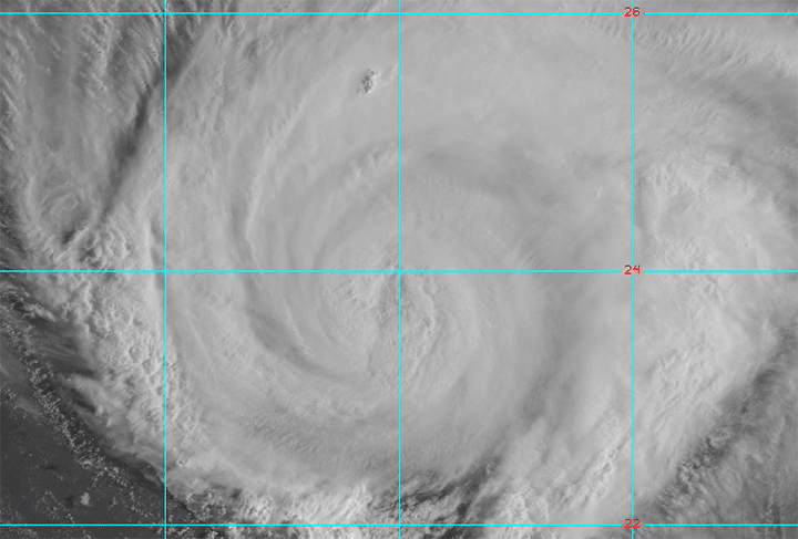
It's all very confusing for a storm that, rather than dissipating or taking a northward turn on its trek across the eastern Pacific basin, has stayed the course as a hurricane and crossed over into the western Pacific basin where hurricanes are known as typhoons.
The international dateline is what divides the basins and as luck would have it, Japan's Himawari-8 satellite captured Kilo as the dateline cut right through the center of the hurricane (or typhoon or hurriphoon or whatever you want to call it).
The western half of #Kilo is a typhoon and it's Sept. 2, but the eastern half is a hurricane and it's Sept. 1! pic.twitter.com/iljoimCl1M
— Dan Lindsey (@DanLindsey77) September 1, 2015
The last storm to make the trans-basin trek was Genevieve, which did the feat just last year. With warm water ahead of it, Kilo is likely to stay the course as a typhoon and could even intensify. The storm could threaten Japan next week and it could be one of the longest lasting storms on record.
John, a hurricane that also crossed the dateline to become a typhoon, stuck around for 30 days in 1994. With 12 days under its belt, Kilo still has a ways to go, though.
You May Also Like:
Atlantic Storm Sets Records as 3 Others Span Pacific
Large Wildfires Are Now More Common and Destructive
‘Grey Swan’ Hurricanes Pose Future Storm Surge Threat
Better Health a Key Benefit of Renewables, Study Says