
News•August 26, 2015
Tropical Storm Erika Could Hit Florida By Monday

By Brian Kahn
It may just be a dot on the map, but it could be an historic one. Florida has entered the cone of probability in the latest forecast for Tropical Storm Erika.
The forecast, from the National Hurricane Center, shows that Erika could make landfall in South Florida. That would end an unprecedented 10-year hurricane drought in Florida, a state that is usually a hurricane magnet.
Tropical Storm Erika's cone of probability, issued on August 26 at 11 a.m.
Credit: NOAA National Hurricane Center
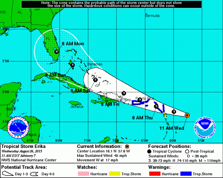
Of course, Monday is a long way away in hurricane forecast time (which is somewhat similar to dog years) and a lot of uncertainty sits between Erika and ending Florida’s historic hurricane drought in terms of whether the storm makes landfall and how strong it is.
As it stands now, Erika is a tropical storm with sustained winds of 45 mph. Much like it’s predecessor Danny — the first hurricane of the 2015 Atlantic season — Erika is forecast to pass through the northeastern Caribbean. The storm should make it ways through the Bahamas over the weekend.
RELATEDU.S. Hurricane Drought ‘A Matter of Luck’
Hurricane Danny Takes Aim at Drought-Parched Caribbean
Katrina: Lasting Climate Lessons for a Sinking City
What happens after the Bahamas is an area of intense speculation. Also like Danny, Erika faces a fair amount of wind shear in the eastern Caribbean on Thursday and Friday (thanks, El Niño). That could tear the storm apart.
But if it can make it through, there’s less shear and warm waters on the other side that could help the storm strengthen. The National Hurricane Center shows Erika reaching Category 1 hurricane status on Monday morning with a forecast track that could make it the first hurricane to hit Florida’s shores since Hurricane Wilma in 2005. Wilma was also the last major hurricane — Category 3 or greater — to the hit U.S.
Nailing where landfall happens is not a slam dunk. Far from it. The uncertainty is a 240-mile wide circle so even though there’s a dot on South Florida, it’s not a guaranteed bullseye.
Today: GFS 12z forecast for TS #Erika slides up east coast of Florida—still 4-5 days away. Heavy rain threat. pic.twitter.com/MJolVO5bl1
— Ryan Maue (@RyanMaue) August 26, 2015
There’s still not widespread agreement among the models used to forecast tropical storms on Erika’s strength either. Some models show Erika could spin up into a major hurricane while others have it staying more low key as a tropical storm or wave.
All that said, there are some warning signs that Erika’s track could bring it to South Florida in some form. At Wunderground, Bob Henson writes that the “overall pattern is the most favorable I’ve seen in a long time for a potential Florida landfall.” The Capital Weather Gang’s Brian McNoldy also also notes that South Florida landfall is the most likely possibility as does Eric Holthaus at Slate.
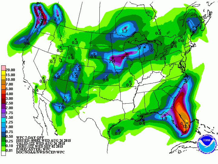
What most models do agree on is rain and lots of it. Up to 12 inches of rain could fall off the coast of South Florida. Parts of the state are in severe to extreme drought so the rain will likely help ease water woes there.
Seven-day precipitation forecast for the U.S., including potential rain impacts from Erika.
Credit: NOAA WPC
Areas that won’t have to speculate about Erika impacts are along the storm's path in the Caribbean. Tropical storm warnings have been issued in Puerto Rico and the Virgin Islands where up to 8 inches of rain could fall through Friday.
Islands in the region could benefit from Erika’s rains if not its winds as many are in the midst of severe drought. Of course, heavy rains on dry soil could also cause mudslides and other hazards so it’s a fine line between enough rain to start refilling reservoirs while avoiding catastrophe.
You May Also Like:
Katrina: Lasting Climate Lessons for a Sinking City
Wildfires Are Ruining the National Park Service’s Birthday
White House: Efficiency Key to Tackling Climate Change
Drought-Fueled Wildfires Burn 7 Million Acres in U.S.