
News•August 21, 2012
Tropical Storm Isaac Forms, Could Threaten U.S.

5 PM STORY UPDATE: Hurricane Hunter aircraft found that the tropical depression had intensified and it has now officially been upgraded to a tropical storm, with maximum sustained winds of 40 mph. The track and intensity forecasts are largely unchanged from earlier today.
A tropical depression lurking about 500 miles east of the Lesser Antilles is forecast to develop has developed into tropical storm Isaac, and could intensify into a formidable hurricane while traversing through the Caribbean during the next five days. Some computer models are projecting ominous scenarios for the Southeastern U.S., including the possibility that Florida could be dealing with a hurricane or tropical storm during the time of the Republican National Convention in Tampa, which takes place from August 27-30.
Official Track forecast for what is likely to become Tropical Storm Isaac. Click on image for a larger version. Credit: National Hurricane Center.
As Climate Central reported in June, Tampa is one of the most vulnerable U.S. cities to hurricanes, as it is long overdue for a direct hit, and is extremely vulnerable to storm surge flooding. Using Climate Central’s Surging Seas sea level rise mapping tool — it is evident that there are about 125,000 people currently living below the 100-year flood level of 6.5 feet in the Tampa-St. Petersburg area. In St. Petersburg alone, there are more than 45,000 homes that lie below 6 feet in elevation, and would likely be vulnerable to a storm surge of that magnitude or greater.
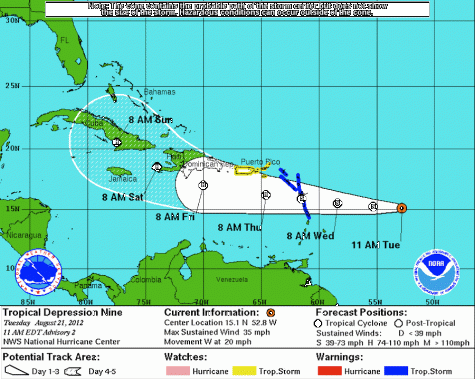
The ultimate fate of T.S. Isaac is far from clear, with myriad forecast scenarios. The storm, which has maximum sustained winds of 40 mph, is moving due west at 17 mph. Computer model projections show that the storm is likely to affect the Lesser Antilles as well as the islands of Hispaniola and Cuba, either passing over these areas or just offshore, before it potentially moves closer to the U.S. coast early next week. The extent to which it interacts with these land areas will greatly influence the storm’s intensity when, or if, it threatens the U.S. mainland.
Tropical storm warnings have already been hoisted for numerous vacation hotspots, including the islands of Martinique, Dominica, Guardeloupe, Anguilla, and Barbuda, along with St. Maarten and Saba, among others. A tropical storm watch is in effect for the British Virgin Islands, Puerto Rico, Vieques, Culebra, and the U.S. Virgin Islands. A tropical storm warning means that tropical storm conditions are expected somewhere within the warning area within 36 hours, whereas a watch means that tropical storm conditions (with sustained winds between 39-73 mph) are possible within 48 hours.
Long range projections of Isaac's track generated from different runs of the GFS computer model. Click on the image for a larger version. Credit: National Center for Atmospheric Research.

According to the Hurricane Center’s 5 p.m. advisory, the storm is expected to move westward during the next 72 hours, followed by a turn to the west-northwest after that point, along with a slowdown in its forward speed. The storm is expected to be in a favorable environment for strengthening beyond the next 24 hours or so, with plenty of very warm water to feed off of and low amounts of wind shear to contend with.
The National Hurricane Center's forecast calls for Isaac to intensify into a hurricane with maximum sustained winds of 90 mph 85 mph within three days. Many Some of the computer models that forecasters use to guide their projections show the storm intensifying into a Category 2 hurricane on the Saffir-Simpson scale, with sustained winds of 96 to 110 mph. However, long-range track forecasts contain a significant amount of uncertainty, while intensity projections are even more fraught with unknowns.
Brian McNoldy, a hurricane research scientist, wrote for the Capital Weather Gang blog that multiple scenarios exist at this point. “The south Florida landfall is one scenario, so shouldn’t be taken too seriously (yet), but also shouldn’t be ignored. It’s worth noting that this general picture has been painted on several recent [computer model] runs,” McNoldy wrote.
“But drastically different outcomes remain possible. For example, if the storm begins to turn northward a little sooner, it would easily brush by Florida and head up to the Carolinas or even miss the coastline altogether. If it takes a little longer to turn north, the storm would could bypass Florida and enter the Gulf of Mexico.”
If a Hurricane Isaac were to strike the U.S. as a major hurricane of Category 3 strength or greater, it would end a record long major hurricane drought in this country. The last major hurricane to strike the U.S. was Hurricane Wilma (Category 3) in 2005, which came ashore in Southwest Florida. It was the fourth costliest hurricane in history at the time, with damages totalling $21 billion.