
News•March 13, 2014
East Greets Winter's End; West Braces for Drought, Fire

By Brian Kahn
February marked the end of winter in the meteorological sense. And while those on the East Coast are likely looking forward to turning the page on a seemingly cold and wet winter, the dry and warm conditions that dominated the West could leave residents there bracing for more drought and an intense wildfire season.
But despite a seemingly endless winter for those in the East, for most of the states from Georgia to Maine, it was just an average winter. Not a single state on the Eastern Seaboard experienced a top 10 coldest winter.
A map showing winter 2014 temperatures by state.
Credit: National Climatic Data Center
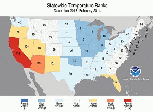
That’s according to the February climate numbers released on Thursday by the National Climatic Data Center. Those numbers show the nation as a whole ran 1.6°F below the 20th century average, making this the 37th-coldest February in 119 years of record keeping. Combined with December and January’s temperatures, that also makes this the 34th-coldest winter on record.
Some cities did experience heavy snowfalls. Philadelphia received 59.5 inches of snow, more than triple its winter average for 1981-2010. New York wasn’t far behind with 57.3 inches, also nearly triple its winter average. In the South, a crippling February ice storm also delivered 4.6 inches of snow to Atlanta, more than double its normal 2.1 inches.RELATEDNew Mexico Facing ‘Extremely Destructive’ Wildfire Season
Warming Winters: U.S. Temperature Trends
Winter Storm of ‘Historic Proportions’ To Slam Southeast
People living in the Upper Midwest may have more legitimate claims to griping about cold weather. Seven states in that region had their top 10 coldest winter. In February, the daily coldest temperature in the continental U.S. was registered in Michigan, Minnesota or North Dakota on 18 of the 28 days in the month. That included a five-day stretch in Embarass, Minn., where the mercury bottomed out at -30°F or lower each day from February 8-12.
Across the U.S., daily cold records outpaced daily warm records by 4-to-3 in February. That marks the fifth month in a row that daily cold records topped daily warms records, the first time that’s happened since 1997.
This winter marks a sharp break with long-term climate trends. Using all 119 years of temperature data show the Upper Midwest and Northeast are two of the fastest-warming regions in the country. Average winter temperatures are rising 3.1°-6.0°F per century across large portions of those regions. Outside a few isolated areas of the Southeast, the U.S. in general has seen a winter warming trend.
A map showing average winter temperature trends looking across 119 years of data.
Click the image to enlarge. Credit: National Climatic Data Center
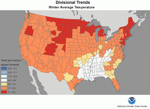
That, in part, helps explain why so many in the Northeast felt so cold this winter. In a sense, average temperatures are the new cold.
In comparison, parts of the West have continued the trend of warmer winters. California had its hottest winter on record. This winter’s average temperature was 48.0°F — 4.4°F above the 20th century average, and 0.8°F above the previous mark set in 1980-81. The state’s neighbor to the east, Arizona, also had its fourth-warmest winter on record.
Dry weather was an equally important story for the West. In contrast to the snowy East, only a handful of storms brought precipitation to California, with most of it coming in January and February.
Those storms did save California from having its driest winter on record, but “third driest” is hardly consolation to a state reeling from huge precipitation deficits over the past year. Arizona and New Mexico also saw a dearth of precipitation contribute to their third-driest winters on record.
The arid winter in California and throughout most of the West helped drought spread across the region. That has led to ominous warnings about wildfire season.
The U.S Drought Monitor released new data on Thursday that showed drought increased across the western U.S. this winter despite small improvements from February to March. Drought covered 49.5 percent of the region in early December. By the first week of March, 58.65 percent of the region was experiencing some kind of drought.
Extreme or exceptional drought, the worst categories, more than doubled over the winter. More than 15 percent of the region is now dealing with those severe conditions. The worst of it centered over California and Nevada, but western New Mexico has also seen extreme drought rapidly expand over the past month.
The U.S. Drought Monitor and National Weather Service warned that California and New Mexico could be in for an explosive season with so much dry fuel on the ground. Parts of California, New Mexico and Arizona have already see fires ignite this winter, which is well outside the norm for this time of year.
You May Also Like
Social Cost of Carbon Greatly Underestimated: Report
Three EU Countries Hit 2020 Renewable Benchmarks Early
Did Spate of Wet Weather Fuel the Reign of Genghis Khan?
March Madness, NASA Style: Cast Your Vote Now