
News•February 20, 2014
Play It Again: January Continues Globe's Warm Trend

By Brian Kahn
Talk about a hot streak.
Last month was the fourth-warmest January since recordkeeping began in 1880. It was also the 347th consecutive month with above-average temperatures compared to the 20th century average, which has been fueled in large part by climate change. That streak is one month shy of 29 straight years.
Global average temperatures were also among their top 10 warmest for the ninth straight month, according to data released Thursday by the National Oceanic and Atmospheric Administration (NOAA).
A map showing global average temperature anomalies for the month of January 2014.
Click image to enlarge. Credit: National Climatic Data Center
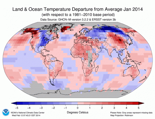
Global average temperatures over land and sea in January checked in 1.17°F above the 20th century average. This is the 38th consecutive January with above-normal temperatures and the warmest since 2007. The last January cooler than the 20th century average was in 1976, the month the Concorde took its inaugural flight and Jimmy Carter won the Iowa caucus.
Siberia was the most anomalously cold place on the planet, with temperatures running as much 9°F below the long-term average. However, many more areas experienced above normal temperatures. France, Spain, Austria, and Switzerland all recorded one of their top 5 warmest Januarys on record. A series of strong winter storms have also drenched the region. China had its second-warmest January recorded while much of southern Africa experienced record warmth. A heat wave also vaulted Australia to its 12th-warmest January since 1910.RELATEDIn Australia, 2013 Was a Scorcher for the Record Books
2013 is 4th Hottest (or 7th); Either Way, it’s Toasty
Arctic Sea Ice Sits at Record Low for Mid-February
January’s Temps Leave a Nation Blowing Hot and Cold
Along with Siberia, the eastern U.S. was one of a few pockets on the planet that experienced colder-than-normal land temperatures. However, cool temperatures in the East were balanced by increased heat in the West, which shows no signs of letting up anytime soon.
NOAA’s newly released forecast for the U.S. shows that the area from Washington through the Four Corners and down to Florida is likely to experience above-normal temperatures during the next three months. Below-normal rainfall is also forecast for California and parts of Arizona and Nevada, which means the region’s drought is likely to worsen.
“We are now in February and past the peak of the California wet season. If this were baseball we would have run through all of our heavy hitters,” said Deke Arndt, a climatologist at the National Climatic Data Center, in a conference call on Thursday.
That’s ominous news for California, where up to 20 inches of rain is needed to help the state get out of drought conditions. Through February 16, the state had received 4.54 inches of rain since October. That puts the odds at 1-in-1,000 that the state reaches even average precipitation according to the National Weather Service.
A map showing how much rain different parts of California would need to escape the current drought.
Click image to enlarge.

Drought conditions are so bad in California that more than two-thirds of the state is considered in exceptional or extreme drought according to the latest Drought Monitor, which was also released Thursday. Exceptional drought, the most dire drought classification, covers nearly 15 percent of the state.
Arndt said that this month is the first time exceptional drought has been used in California in the Drought Monitor’s 15 years of existence.
With the odds for heavy precipitation increasingly low, drought is likely to persist into the summer for California and the Southwest, where New Mexico just experienced its driest January on record. In the upper Midwest, where pockets of drought have persisted, a series of storms associated with the polar vortex brought enough snow to help ease conditions.
But that does little to help with the West’s current water woes. A longer-range hope could come in the form of an El Niño event in the fall. El Niño’s tends to bring rainier than normal conditions to California and the Southwest. Climate models indicate the odds of that are increasing, but it’s not a given.
Dan Collins, a research meteorologist at NOAA’s Climate Prediction Center, said that the odds are about 50/50 for El Nino to develop in the late summer or early fall.
In addition to increasing the odds for rain in parts of the West, an El Niño event would also likely goose global temperatures. On top of manmade global warming and other climate cycles, that means monthly temperature updates are likely to continue playing the same tune.
You May Also Like
Arctic Sea Ice Sits at Record Low for Mid-February
Climate Trends Tell Different Story for Great Lakes’ Ice
Flurry of Coal Power Plant Shutdowns Expected by 2016
Never-Ending Winter? Nah, January in U.S. Was Average
Study Sounds ‘El Nino Alarm’ for Late This Year