
News•December 19, 2014
Picture This: It's Beginning to Look a Lot Like Winter
The days have been growing shorter and the air chillier as winter approaches. It will officially arrive on Saturday, with the winter solstice. The good news is that after that, the daylight lasts a little bit longer every day! But there’s a lot of winter weather ahead of us, and it’s already started, from weird ice pancakes forming on a river in Scotland to massive snow in Japan. And, for good measure, a special Christmas forecast.
Where Did Atlanta Go?
As the beginning of the workweek dawned in the Southeast’s biggest city, only the tallest spires of downtown Atlanta could be seen poking out above a thick layer of fog.
Midtown & Downtown Atlanta is lost under the Monday morning fog. @wsbradio SkyCopter @wsbtv Capt'n Cam view pic.twitter.com/YQjHddwTer
— Mark McKay (@mckayWSB) December 15, 2014
Fog is just like any other cloud, made of water droplets suspended in the air, only in this case, they’re right at the Earth’s surface. Fog isn’t an unusual sight in winter, as the clear skies and calm weather that often prevail allow the land, and therefore the air nearest it, to cool during the night. As the air cools, the water in it condenses out.
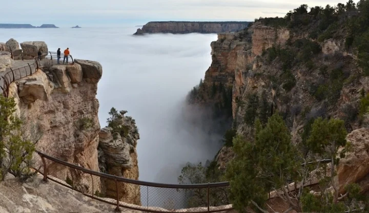
A much more impressive-looking and rarer fog invaded the Grand Canyon last week, taking social media by storm:
Fog seeping through the Grand Canyon gave visitors a rare and spectacular site in December 2014.
Credit: National Park Service
Post by Grand Canyon National Park.
This fog formed because of what is known as a temperature inversion. Typically, warm air rises and sits above colder, denser air, but in this case, a shallow layer of cold air was kept trapped below warmer, heavier air, Slate’s Eric Holthaus explained.
Ice Pancakes
Another fantastic winter phenomenon was found by biologist Jamie Urguhart on the River Dee in Scotland: some bizarre-looking discs called “ice pancakes.”
River Dee ice pancakes on BBC News this morning #icepancakeshttp://t.co/6iTHmjazmxpic.twitter.com/t9IpmvKNsp
— The River Dee (@RiverDeeTeam) December 18, 2014
These strange ice patties form when ice crystals get knocked around by waves, sticking together into these round shapes.
More of this pancake ice has been spotted in the Arctic in recent years. It is thought that as sea ice has melted with warming ocean waters, the seas have become rougher since waves can travel over larger stretches of open ocean.
Let It Snow?
Singing that classic Christmas carol probably wouldn’t make you a popular person in Japan this week, as a storm dumped quite a bit of the white stuff on the nation. According to the Weather Channel, Tsunan received 81.5 inches of snow, or nearly 7 feet!
The snow was enough to bury these vending machines in Minamiuonuma:
Photo: Vending machines buried in #snow in Minamiuonuma, Japan Monday. (Credit: http://t.co/OuZ8RMVDPd) pic.twitter.com/SoPBFYBwx4
— Jonathan Erdman (@wxjerdman) December 16, 2014
Christmas from Space
Every neighborhood has that house that goes so over the top with the Christmas lights that you’re pretty sure it’s visible from space. Turns out, it kinda is . . .
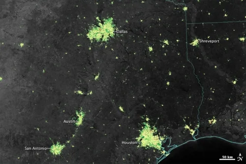
NASA scientists took a look at daily data from the Suomi NPP satellite and found that the nighttime light intensity around many major U.S. cities was 20 to 50 percent brighter around the holiday season. (The same was true of some Middle Eastern cities during the Muslim holy month of Ramadan.)
The team made maps showing how much brighter cities got from Christmas to New Year’s compared to the rest of the year:
The nighttime lights of Texas around the Christmas and New Year's holidays are brighter than they usually are.
Click image to enlarge: Credit: NASA
Best Christmas Forecast Ever
When it comes to the weather on Christmas, there’s something almost everyone wants to know: What are the odds of a White Christmas?
For most of this week, it’s been too far out to say with confidence whether the skies will be clear or whether there will be a blanket of white on the ground, or if a windy, rainy storm will mess up holiday travel. But Gary McManus at the Oklahoma Mesonet Ticker consulted his charts and came up with a pretty satisfying Yuletide forecast:
Happy Holidays!
Credit: OCS Mesonet Ticker

You May Also Like:
Tipping Point Nears for ‘Emerging Flooding Crisis’
2014 Set for Record Hot; Record Cold Thing of the Past
Warm Water Invasion Is Fueling Striking Antarctic Ice Melt
Earth, Now Available in Ultra High Definition
Rain a ‘Start’ for Calif., But Drought Entrenched