
News•January 23, 2015
Picture This: Illuminating Lightning & Rare Texas Snow
This workweek was a short one for those of us in the U.S., but it was still packed with plenty of amazing weather images. As usual, some of the most stunning came from the vantage point of space, which offered a new perspective on lightning. Winter also continues to leave its mark, but in sometimes surprising places.
Astronaut’s Eye on Lightning
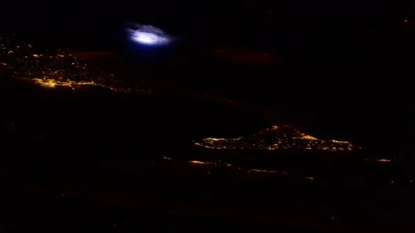
European Space Agency astronaut Samantha Cristoforetti had an eye for lightning this week, snapping two stunning images of strikes lighting up storm clouds from her perch aboard the International Space Station. One was taken over her native Italy:
Lightning illuminates storm clouds over Italy in this photograph taken by ESA astronaut Samantha Cristoforetti from the ISS. Credit: ESA
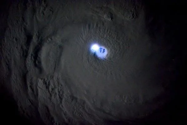
The other was a striking shot (no pun intended) of lightning lighting up the eye of Tropical Cyclone Bansi, which spun up last week over the southern Indian Ocean. It peaked at Category 4 strength on the Saffir-Simpson scale before weakening over the weekend. Mid-January (summer in the Southern Hemisphere) is one of two peak times in the tropical cyclone season for the southwest Indian Ocean.
Cristoforetti also captured this image of lightning lighting up the eye of Tropical Cyclone Bansi over the southern Indian Ocean. Credit: ESA
Lone Star State Snow
While winter has brought bouts of cold down into the eastern U.S., overall the weather has been milder than last winter. And far less snowy than last year, which seemed to feature snowstorm after snowstorm.
Snow fell this week in parts of the Midwest and Washington, D.C., as well as parts of the mountain West. The storm there also sent a rare snow to northeastern New Mexico and the Texas Panhandle, which brought out resident’s cameras to snap shots of the unusual sight:
@BrianJamesWx@SteveKersh7 Castleberry Ranch at Romero Texas. HWY 54 & hwy 767 getting slick now. pic.twitter.com/wUuYmxSE7N
— Simscott (@lathemfarms) January 21, 2015
Just crossed into New Mexico. Photo from highway 412 on the NM/OK border. Crawling towards Clayton. #nmwx#okwx#snowpic.twitter.com/Ep9NGXpnv6
— Storm Chasing Tour (@stormchasetour) January 21, 2015
Some areas saw between 7 and 13 inches of snow — a total usually associated with somewhere like Chicago. In fact, according to the Weather Channel’s Mike Bettes, Amarillo has seen more snow this winter (with 16 inches) than traditional snow centers like Fargo, N.D., Chicago, Boston and Pittsburgh.
Amarillo, TX burried in snow! #txwx#amarillosnow#winter#snow#stormpic.twitter.com/ckSXx4vYHf
— Storm Chasing Tour (@stormchasetour) January 22, 2015
Funny Face
And finally, sometimes the chaotic patterns of the atmosphere can arrange themselves into familiar shapes (or we humans just have a propensity for seeing them), such as this simulation of air currents in the stratosphere (the layer of the atmosphere above the one in which we live):
Why is Earth frowning at us? http://t.co/Vm1IHDzR9K (via http://t.co/yqK2Db2bGM) pic.twitter.com/5qkUmNoBYE
— Capital Weather Gang (@capitalweather) January 19, 2015
The Earth is making faces at us.
You May Also Like:
The Method to Our 1-in-27 Million Madness
Climate Change’s Calling Card in 2014: Heat
The Year’s 7 Most Telling Images From Space
What Holiday Lights Look Like To NASA
Find Out When the Coldest Day Usually Hits Your Town