
News•October 14, 2013
Typhoon Wipha May Threaten Tokyo and Fukushima

Editor's Note: Today's updated story on Typhoon Wipha includes more details on Fukushima's preparations and more recent storm data.
Typhoon Wipha, which is currently a storm with 110 mph winds located several hundred miles south of Kyoto, Japan, appears poised to sideswipe, or possibly even make a direct hit on Japan in the coming days. The storm is expected to bring strong winds, heavy rain, and high waves to the Japanese coast from Tokyo northward, including the ailing Fukushima Daiichi nuclear plant, where cleanup efforts have already hit serious roadblocks.
Computer model projection for accumulated rainfall associated with Typhoon Wipha.
Click image to enlarge. Credit: WeatherBell Analytics.

Current forecasts show Wipha making landfall, or coming close to making landfall, near Tokyo on Tuesday into Wednesday, while transitioning from a weakening tropical cyclone into a hybrid storm, with characteristics of both a tropical storm and an extratropical system. Those characteristics are similar to some of the features that Hurricane Sandy had when it devastated the U.S. East Coast nearly a year ago this month. Wipha could bring an expanded area of high winds and pounding surf along with several inches of rain to heavily populated areas of Japan, including the vulnerable nuclear plant that was incapacitated by the massive earthquake and tsunami in 2011. The tsunami led to a series of cascading engineering failures, culminating in a triple nuclear meltdown at the plant in the worst accident at a nuclear power plant since Chernobyl in 1986.
Ryan Maue, a meteorologist at WeatherBell Analytics, a private forecasting firm, told Climate Central that the storm poses a “huge flood potential” for the Fukushima area. “Deep convection on the westward flank of the storm . . . plus the topography of Japan means heavy rain for the coastline regardless of the Typhoon's track,” he said in an email message. “Wipha is extra-large size-wise,” Maue said, predicting it will grow and strengthen as it makes its closest pass to Japan, aided by strong jet stream winds in the upper atmosphere.
Even in the absence of landfalling typhoons, cleanup work at Fukushima has hit numerous serious roadblocks, with recent discoveries that the plant has been leaking radioactive water into the Pacific Ocean. A team of 16 experts from the International Atomic Energy Agency is currently in Japan to visit the plant and advise the Japanese government on how to deal with the challenge of storing large amounts of radioactive material on site.
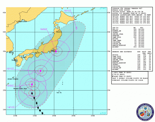
Typhoon Wipha track forecast from the Joint Typhoon Warning Center, as of Monday afternoon Eastern Daylight Time.
Click image to enlarge.
In September, the Japanese government announced it would spend half a billion dollars on additional steps to secure the plant, including building a wall to block the contamination of groundwater. A major storm with high surf, strong winds, and heavy rainfall likely would complicate cleanup efforts, or possibly pose an even greater danger to the facility.
Typhoons are no stranger to Japan, although as in parts of the U.S., by the time these storms reach such northern latitudes they are often transitioning into hybrid storm systems. That may not be good news for Tokyo and Fukushima, though, since this process can cause storms to intensify and expand in size, resulting in a broader wind field and a higher potential for storm surge.
Computer models show the potential for 40-foot waves off the coast of Japan on October 16, with maximum sustained winds close to hurricane force, or 74 mph, along the coast. (A typhoon is the same meteorological phenomena as a hurricane, but these storms are named differently in different ocean basins.)
The worst-case scenario track would take Wipha over the coast just west of Tokyo, which could push a damaging storm surge into parts of the city, and result in a higher surge near the Fukushima area. Given that the storm is still several hundred miles south of Japan, the exact track is still quite uncertain.
Computer model projection showing Typhoon Wipha close to making landfall near Tokyo on Wednesday, Oct. 16.
Click image to enlarge.
Credit: WeatherBell Analytics.

The storm is being monitored by the U.S. Navy's Joint Typhoon Warning Center and the Japan Meteorological Agency (JMA). The JMA is projecting about a 60 percent likelihood that 58 mph sustained winds will occur in the Tokyo Prefecture, with those odds diminishing to about 40 percent for Fukushima Prefecture.
At one point, Typhoon Wipha was part of a trio of intense tropical cyclones from the Western Pacific Ocean to the Bay of Bengal, where Cyclone Phailin made landfall over the weekend. In contrast, the Atlantic hurricane season is cruising to one of its least active years on record, with not a single major hurricane of Category 3 intensity or greater occurring to date. The Atlantic hurricane season officially ends on Nov. 30.
Related Content
Monster Cyclone Phailin Poses Deadly Threat to India
Fukushima's Radioactive Legacy is Just Beginningukushima Two Years Later: Decommissioning Begins
After Fukushima Nuclear Crisis: U.S. Flying Blind