
News•July 2, 2013
Satellite Provides Clues About Deadly Yarnell Hill Fire

The deadly Yarnell Hill wildfire continues to burn out of control on Tuesday, having consumed at least 8,400 acres since it was ignited by a lightning strike on June 28. The fire is responsible for the largest loss of firefighters since the September 11 attacks, having killed 19 members of a 20-man “hotshot” crew that was battling the blaze on Sunday when something went terribly wrong.
Erratic weather conditions are the prime suspect behind the firefighters' deaths, with gusty and highly variable winds fanning the flames in multiple directions as a line of thunderstorms approached the fire.
The University of Wisconsin's Cooperative Institute for Meteorological Satellite Studies published a blog post that, like a detective at a crime scene, searched for clues regarding the events that led to the most wildfire firefighting deaths in a single blaze since 1933.
Visible satellite loop of the Yarnell fire around the time of the firefighting tragedy on June 30. The red circle indicates the location of the fire.
Credit: CIMSS Satellite Blog
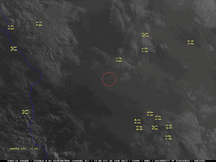
This animation of visible satellite imagery from the GOES-15 satellite shows the smoke plume associated with the growing Yarnell Hill fire on Sunday, as favorable conditions for wildfire growth affected the area, with temperatures climbing to triple digits, low relative humidity, and gusty winds. The wildfire was occurring in an area affected by a long-term drought and warming trend.
The satellite animation shows the development of clouds known as “pyrocumulus clouds,” which are billowy, tall clouds produced by large wildfires. This is a telltale sign of a highly active wildfire.
Next, as the clouds from an area of thunderstorms approaches the fire zone from the north, the images show a towering “pyrocumulonimbus” cloud protruding through the broader cloud deck, in what is known to meteorologists as an “overshooting top.” This means that the cloud plume comprised of smoke and particles from the fire, mixed in with the water droplets and ice crystals from the thunderstorm clouds, was reaching high altitudes, possibly up to 40,000 to 50,000 feet.
Here's how NASA describes such “pyroCb” clouds: “An explosive storm cloud actually created by the smoke and heat from fire, and which can ravage tens of thousands of acres. And in the process, “pyroCb” storms funnel their smoke like a chimney into Earth's stratosphere, with lingering ill effects.”
The presence of this towering fire-related cloud indicates that the wildfire was likely undergoing explosive growth at the time, and that clue, combined with evidence from a nearby surface weather station that showed highly variable and gusty winds at that time that the firefighters lost radio contact, suggests that the firefighters were overwhelmed by the sudden change in the fire's behavior.
The National Oceanic and Atmospheric Administration (NOAA) has sent an incident meteorologist, known as an IMET, to be embedded with the Yarnell HIll firefighting teams. As specially trained National Weather Service meteorologists, IMETs work with firefighters on the ground to provide fire-specific forecasts that anticipate rapid changes in fire behavior. They don't deploy unless requested by fire commanders at the scene.
The Yarnell Hill fire was initially small, and did not pose a major threat to homes until it rapidly expanded on Sunday. Firefighters did request a wildfire-specific “spot forecast” from the local National Weather Service forecast office Sunday, which warned of shifting wind conditions associated with afternoon thunderstorms.
In a press conference in Maryland on Tuesday, Acting NOAA Administrator Kathryn Sullivan said that in many cases, IMET crews would have worked with hotshot crews such as the one that was overrun, but that no request had been made until after Sunday's tragedy.
“Had we have been there maybe we would have had a better outcome,” Sullivan said.
Related Content
The Climate Context Behind the Deadly Arizona Wildfire
Deadly Heat Wave Continues in West; Wildfire Danger High
Western Wildfires
Heat Wave May Threaten World's Hottest Temp. Record
Global Warming Behind Australia's 'Angry Summer': Study
Hansen Study: Extreme Weather Tied to Climate Change
8 Images to Understand the Drought in the Southwest