
News•February 6, 2015
How Warming May Alter Critical ‘Atmospheric Rivers’
The hose has been turned back on full-force over Northern California: A stream of moisture is flowing over the drought-riddled state and dropping copious amounts of rain just days after the close of one of the driest Januaries on record.
The influx of much-needed rain comes courtesy of a feature called an atmospheric river that is a key source of much of the state’s precipitation and water supply. A relatively recent meteorological discovery, these ribbons of water vapor in the sky are something scientists are trying to better understand. They are flying research planes into the heart of the current storm to study what fuels it, which could help improve forecasts of the events.
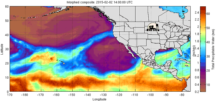
An atmospheric river over the Pacific Ocean is dumping rain on California.
Credit: CIMSS
Because the atmospheric rivers are critical for California’s water supply, scientists also want to pin down how they are being affected by climate change.
“We need to understand more about how climate change will change the amounts of precipitation that they will drop in the future,” Michael Dettinger, a research hydrologist with the U.S. Geological Survey who is actively investigating that question, said.
Wet, Dry, Wet
The relentless drought in California, now in its fourth year, has left the state with a dismal snowpack and below-normal stores in many reservoirs, which has hobbled the state’s agriculture and sent some communities to the brink of waterlessness, among numerous other impacts.
RELATEDA Country Divided by Seasons and Warming
What A Warming World Means for Major Snowstorms
After December Rains, California Comes Up Dry
The drought has reached those depths because of record warmth that has increased water use and evaporation, and an atmospheric setup that has kept most storms over the Pacific from reaching the state during the past few winters, typically California’s wet season. In particular, a tenacious region of high pressure has diverted those storms — and their rains — further north.
“That’s been the culprit these last three winters,” said Allen White, a meteorologist with the CalWater 2015 project, which is using research ships and planes to intensely study the storms.
The pattern has periodically shifted and allowed the atmospheric rivers to flow in, as they did in December when record rains fell on parts of Northern California. But those record rains were followed by weeks of nothing. San Francisco marked its first January on record (going back to 1850) with no rainfall — an unbreakable record.
Now, the high pressure system has shifted again and the flow of moisture has turned back on. This atmospheric river is expected to bring significant rainfalls of 5 to 10 inches in mountainous areas and 1 to 5 inches in valleys as the storm hits the mountains of Northern California. (The mountains force the air upward, causing it to cool and the water vapor in it to condense out and fall as rain.)
ICYMI: Here's the latest on forecast precip for incoming storm! #cawxpic.twitter.com/zcDHZSNey5
— NWS Sacramento (@NWSSacramento) February 5, 2015
But while the rain is a welcome change, the fact that it has been so dry means that “the soil and the ground is going to soak up a lot of this water,” and reservoirs won’t benefit as much as if it had been a normal, wetter winter before this, White said.
Another downside is that the storm is very warm, as it is pulling moisture from the tropics near Hawaii, so any snow that falls will only be at high elevations in the Sierra Nevada range. The snowpack that accumulates in the winter months is a critical part of California’s water supply, slowly melting and refilling reservoirs in the spring and summer, and it is needed across a wider swath of the mountains.
“Sierra snowpack will likely remain near record low values even after heavy precipitation (mostly as rain) this weekend,” Daniel Swain, a Stanford University PhD student who studies extreme weather events, said.
Flying Into The Storm
Atmospheric rivers were only recognized in the late 1990s, and there is still much to learn about them.
These rivers don’t just occur off California, with about seven to 12 of them “forming, moving, or dying someplace in the world” at any given time, Dettinger said. As a whole, they move around most of the atmosphere’s water vapor outside of the tropics, making them an important influence on weather and climate.
For the U.S. West Coast, the concentrated punch of atmospheric rivers have been responsible for more than 80 percent of all major historical floods and account for 30 to 50 percent of all the precipitation those areas see. Atmospheric rivers have busted previous droughts, though the current one won’t cure the ongoing drought, which will take years to recover from.
“If you get a normal winter, you’ll have five to seven of these atmospheric rivers,” White said. The last few winters have seen only two or three — “that’s been the problem,” he said.
Monumental day in wx research- 4 planes & a ship sampling #AtmosphericRiver in CA. @NOAA@NWS@NASA#CalWater2#CaWxpic.twitter.com/zSj3FKxRHB
— NWS Sacramento (@NWSSacramento) February 5, 2015
White and his team are lucky this one finally cropped up when it did, as they only have their research ship and one of their planes through early next week. What they’re hoping to learn by flying through and sailing under the plume of moisture as it moves onshore are two things that could help improve how atmospheric rivers are represented in weather forecast models. One is how much of the water vapor in the atmospheric rivers comes from the ocean (via sea spray and waves) and the other is how dust and other particles in the atmosphere affect the amount of precipitation they drop.
“I think this will be a very interesting case,” White said.
What Will Warming Do?
Another issue researchers are trying to better understand is how a warmer atmosphere will impact atmospheric rivers — a key consideration for areas that so depend on these features for water.
Climate models and basic physics suggest that atmospheric rivers will become moister and more intense in the future, as a warmer atmosphere can hold more water vapor (about 4 percent more for every degree 1°F of warming).
But, as with this storm, that may only mean more rain, not snow. Winters in California are expected to continue warming, so “it's pretty likely that the average elevation at which snow falls during [atmospheric rivers] (and at other times) will increase,” Swain said.
Whether they will become more frequent visitors to the West Coast (or anywhere else they appear) isn’t totally clear. Dettinger says that projections so far show more such storms arriving as the climate changes, and because of that “we should expect to encounter big ones more often.”
“The more times I roll the dice, the more often I will get snake eyes; there are just more opportunities for something dramatic to happen if I try a lot more times overall,” he said.
You May Also Like:
Winter Is Losing Its Cool
U.S. No. 2 to China in Clean Energy Investments in 2014
Here’s What the Inside of Greenland Looks Like, in 3D
What If Sandy’s Surge Swamped Washington, D.C.?