
News•October 19, 2015
A New Blue Marble Every Day, Courtesy of NASA

By Brian Kahn
NASA, may be a multi-billion dollar space agency, but in some ways, it’s just like you. It takes 12-megapixel photos just like you with your iPhone 6S and it likes to share them every day in real-time.
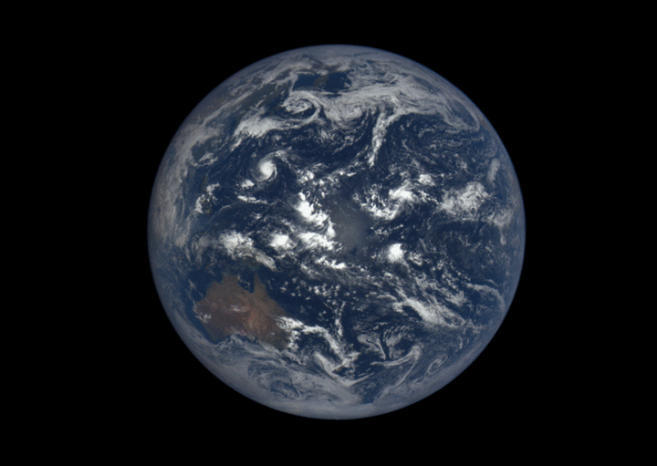
Images taken on Sept. 17, 2015 by NASA’s Earth Polychromatic Imaging Camera camera on the Deep Space Climate Observatory.
Credit: NASA
Of course, it also has a few slight advantages you’re probably not going to compete with. For one, it’s latest camera is attached to a satellite 1 million miles away as opposed to your phone located a few feet above the planet’s surface. And while you might get a nice shot of latte art that’s Instagram-ready, NASA has a killer view of the earth against the black void of space that’s evening news-ready (and probably doesn’t look so bad on Instagram either).
The dynamo of a camera even has an amazing name: EPIC, shorthand for Earth Polychromatic Imaging Camera. It’s attached to the Deep Space Climate Observatory, a space-weather monitoring satellite launched earlier this year.
RELATEDNASA Shows Off Spectacular New Blue Marble
Zombie Satellite Comes Alive In New Life as DSCOVR
Shutdown Could Delay NOAA Satellites, Climate Report
The satellite’s main goal is to monitor space weather and warn of incoming solar storms that could disrupt telecommunications. But NASA and the National Oceanic and Atmospheric Administration, which manages the satellite, have also made sure the satellite can keep an eye directly on earth.
It’s position allows it to see the whole planet. As earth spins, EPIC snaps a picture of its sunny face. The pictures it takes are being made public daily, in an effort to inspire maximum awe at our capabilities to monitor our planet (or FOMO if you’re a glass half empty kind of person).
Scientists can use the images as well as a radiometer also aboard the satellite to monitor the big picture of what’s happening at home. The data will help scientists create dust and volcanic ash maps of the entire world as well as monitor different aspects of the earth’s atmosphere including aerosols and ozone and other aspects of the earth’s reflectivity, a key component of the climate system. For example, global warming is causing the planet’s ice to recede. As that happens, the planet absorbs more sunlight and temperatures rise even more.
The satellite has been nearly 20 years in the making. Then-Vice President Al Gore initially conceived of the satellite in 1998 as a way to monitor the earth. At the time, it was named “Triana” after the member of Christopher Columbus’s crew who first caught sight of the New World.
It was built but later mothballed during the Bush Administration before being brought out of storage by the Obama Administration in 2011. It was launched into orbit earlier this year and sent back a blue marble image that garnered headlines in July.
The satellite is the first deep space earth-monitoring satellite mission the U.S. has ever undertaken, though the images it’s returning are certainly not the first time NASA has upstaged you on Instagram.
You May Also Like:
This is the First Full Earth Image From a Weather Satellite
American Icons Threatened by Sea Level Rise: In Pictures
El Niño Keeps Antarctic Sea Ice From Another Record Max
Energy Industries Invest in Contest to Recycle Emissions