Climate Matters•March 29, 2023
Atmospheric Rivers
KEY CONCEPTS
Atmospheric rivers carry vast amounts of moisture globally from the tropics to the poles.
On their way through mid-latitudes, landfalling atmospheric rivers can dump intense pulses of rain and snow over U.S. regions including the West, Southeast, Midwest, and Northeast.
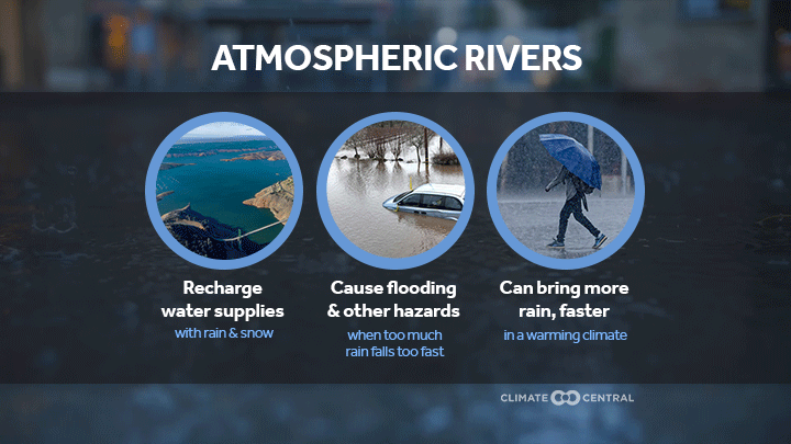
In the West, atmospheric rivers bring vital freshwater resources and can relieve periods of drought.
But strong back-to-back atmospheric river storms can also bring serious hazards such as extreme rainfall, flooding, landslides, debris flows, avalanches, and levee breaks.
A warmer atmosphere can hold more moisture, boosting the potential for warmer, wetter, and more intense atmospheric river storms with greater flood risks and higher costs.
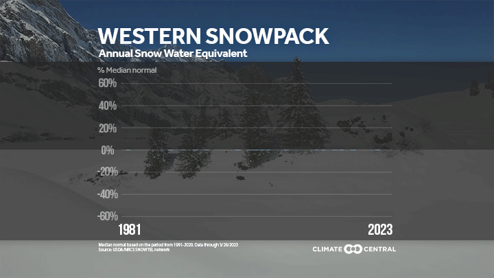
Annual snowpack surveys on April 1 indicate how much snow-derived water will be available through the summer for households, farms, and cities across the West.
But April 1 snowpack readings have increasingly been a bust. For decades, western snowpack has been shrinking and peaking earlier, meaning that smaller supplies need to stretch longer into the year. In the Sierra Nevada, the source of one-third of California’s water, five of the last 10 years had April 1 snowpack levels less than 50% of the historic average.
But 2023 is bucking these trends. California’s snowpack is more than double the April 1 statewide average. The Southern Sierra has already hit record April 1 snowpack levels. And average snowpack across the western U.S. has exceeded levels not seen on April 1 for 40 years.
That’s nearly all to do with atmospheric rivers.
Earth’s largest rivers are in the sky
Atmospheric rivers are ribbons of moisture carried by strong winds in the lower atmosphere.
Engines of the global water cycle, atmospheric rivers carry vast amounts of moisture from the tropics to the poles—accounting for 90% of the total water vapor that moves across Earth’s mid-latitudes, where the U.S. is located.
An average atmospheric river is about 1,200 miles long, 300 miles wide, and nearly two miles deep. Strong ones can move moisture at 15 times the discharge rate of the Mississippi River.
This moisture condenses and falls as intense pulses of rain or snow when atmospheric rivers flow inland and over mountains.
Atmospheric rivers are vital yet risky—especially in the West
Globally, precipitation from atmospheric rivers accounts for 22% of total runoff. In the U.S., atmospheric rivers contribute to most extreme precipitation events in several regions—including parts of the West, Northwest, Southeast, Midwest, and Northeast during fall, winter, and spring.
But atmospheric rivers are especially vital in the West. In California, up to 50% of total annual precipitation and streamflow can come from a few intense atmospheric rivers during fall and winter.
The West receives most of its precipitation during winter, when atmospheric rivers add to snowpack that later melts and recharges the reservoirs that supply freshwater to cities, ecosystems, and farms. Atmospheric rivers are therefore essential for western water supplies.
But atmospheric rivers vary in their strength—and their impacts. Although they provide essential water resources and relieve regional drought, strong atmospheric rivers can cause a range of serious hazards including floods, landslides, and levee breaks.
Atmospheric rivers quench the parched West
Persistent drought across the western and central U.S. from 2020 to 2022 cost an estimated $37 billion in damages—impacting livestock and crop production, halting the Lake Oroville hydroelectric power plant, and depleting large reservoirs including Lake Mead (the nation’s largest), which reached its lowest level since it was filled nearly 100 years ago.
This underscores the benefits that atmospheric rivers bring as drought busters. From 1950 to 2010, landfalling atmospheric river storms broke up to 74% of West Coast and Pacific Northwest droughts and up to 40% of California droughts.
Atmospheric rivers have brought drought relief again in 2023. California’s drought coverage dropped from 98% in December 2022 to 36% in March 2023 as a series of at least 12 atmospheric rivers hit the West Coast. This marks the first time since 2020 that none of California was in exceptional or extreme drought.
Drought conditions have also improved across the entire West—parts of which had been experiencing exceptionally severe and prolonged drought since 2000. Drought conditions are expected to continue to improve through the spring of 2023 as record snowpack melts and tops up reservoirs.
Precipitation is precious, but not all at once
The rating scale for atmospheric rivers reflects that they can be beneficial, hazardous, or both—depending on the amount of moisture they hold and how long they last.
Weak atmospheric rivers are mostly beneficial, providing essential water resources and improving drought conditions.
But stronger atmospheric rivers can be mostly hazardous—especially when they occur back-to-back, after other extreme events (e.g., drought, wildfire), or over extended periods of time.
The series of strong, back-to-back atmospheric rivers in the West from December 2022 to March 2023 have brought serious hazards including extreme rainfall and flooding, rain-on-snow events, widespread power outages, landslides, and debris flows.
Extreme rainfall in central California caused a levee break along the Pajaro River on March 10, flooding the community of Pajaro. Historically, 81% of levee breaks in the Central Valley are associated with atmospheric rivers.
Flooding and landslide hazards could continue through the spring as historic snowpack volumes melt.
Hazards associated with atmospheric rivers aren’t only dangerous—they’re also costly. Atmospheric rivers drive most of the economic losses from flooding in the western United States. From 1978 to 2017, atmospheric rivers accounted for $42.6 billion in estimated flood damages across 11 western states—about $1.1 billion annually. And flood damages increase exponentially with AR intensity and duration. The strongest atmospheric rivers cause hundreds of millions of dollars in damages per storm, on average.
Atmospheric rivers in a warming world
Extreme weather events, including strong atmospheric river storms, have multiple contributing factors. Climate change can create conditions that make extremes more likely or more intense.
Warmer air holds more moisture, increasing the potential for heavy rainfall in a warming climate. For every 1°F of warming, the air can hold an extra 4% of moisture. The U.S. has already warmed by 2.6°F since 1970—meaning our atmosphere can hold about 10% more moisture on average.
More moisture in warmer air can boost total atmospheric river precipitation. Research suggests that this thermodynamic relationship could drive future increases in total precipitation during atmospheric river storms in California.
Projected increases in total precipitation range up to 40% along the windward western slopes of the central and southern Sierra Nevada mountains.
The adjacent Sacramento and San Joaquin valleys could also see 35–50% increases, respectively.
More precipitation, more quickly. Hourly precipitation intensity during atmospheric rivers could also increase by 27% over the Sierra Nevada with continued warming. Short bursts of heavy precipitation can increase the risks of flash flooding and landslides. These events can be especially hazardous because their rapid onset limits time to issue warnings and get people out of harm’s way.
As storm intensity increases with warming, so do the costs. If high rates of carbon pollution continue, flood damages from atmospheric rivers across the western U.S. could reach $2.3 to $3.2 billion annually by the year 2090. That’s between double and triple the historical average.
Warmer storms bring more rain—increasing flood risks and reducing water supplies. Landfalling atmospheric rivers across the West Coast have already warmed significantly since 1980 as our climate has warmed.
Warmer atmospheric rivers drop a higher proportion of rain than snow—even at higher elevations.
This not only decreases the beneficial snow-derived water supplies that the West relies on throughout the year—it also leads to more early spring runoff and worse flooding.
In a future with high emissions and warming, parts of California could see dramatic increases in runoff (up to 50%) from warmer and wetter atmospheric rivers—and even more flood risks.
Risks multiply when extremes interact. A warming climate can also promote rapid shifts between extremes like drought and flooding. The recent extreme precipitation following prolonged drought and intense wildfires in the West is an example of this.
The recent risk of flooding, mudslides, and debris flows was likely made worse because the heavy precipitation brought by atmospheric rivers fell over parched and burn-scarred areas more prone to runoff and erosion.
A growing body of research suggests that the risk of compounding climate hazards, such as those seen during recent atmospheric river storms, is likely to increase with continued warming.
LOCAL STORY ANGLES
Check when and where atmospheric rivers are forecast to make landfall.
NOAA Physical Sciences Laboratory’s Atmospheric River Portal has a range of tools to monitor current conditions and check atmospheric river forecasts. The Center for Western Weather and Water Extremes at the University of California, San Diego, also provides a range of atmospheric river forecast products.
See how western water supplies look for the remainder of the water year (ending September 30).
Use the U.S. Bureau of Reclamation’s interactive map to check current and historical storage levels for 54 major reservoirs across the West. The U.S. Department of Agriculture provides a range of maps, graphs, and reports showing current snowpack conditions at the basin scale across the western U.S. Check current snow water content stored in California’s snowpack using graphs from the California Department of Water Resources.
Does your area face flood risks this spring?
Check NOAA’s 2023 Spring Flood Outlook for expected conditions across the U.S. for April through June. Zoom in on the flood outlook in your area using NOAA’s accompanying interactive map, which highlights areas of minor to moderate flood risk across California and Nevada, related to recent atmospheric rivers. Search your zip code in FEMA’s Flood Map Service Center to find current flood hazards in your area.
CONTACT EXPERTS
Amir AghaKouchak, PhD
Professor
University of California Irvine
Relevant expertise: Compound and cascading hydroclimate extremes
Contact: amir.a@uci.edu
Josué Medellín-Azuara, PhD
Associate Professor
University of California Merced
Relevant expertise: Water resource management; adaptation to climate change
Contact: jmedellin-azuara@ucmerced.edu
*Available for interviews in Spanish and English
Samuel Sandoval Solis, PhD
Associate Professor
Cooperative Extension Specialist in Water Management
University of California Davis
Relevant expertise: Water use, availability, and distribution in a warming climate
Contact: samsandoval@ucdavis.edu
*Available for interviews in Spanish and English
FIND EXPERTS
Tune in to a recent episode of the Water Talk podcast focused on how atmospheric rivers are changing in our warming climate with Dr. Katerina Gonzales and Dr. Daniel Swain.
Submit a request to SciLine from the American Association for the Advancement of Science or to the Climate Data Concierge from Columbia University. These free services rapidly connect journalists to relevant scientific experts.
Browse maps of climate experts and services at regional NOAA, USDA, and Department of the Interior offices.
Explore databases such as 500 Women Scientists, BIPOC Climate and Energy Justice PhDs, and Diverse Sources to find and amplify diverse expert voices.
Reach out to your State Climate Office or the nearest Land-Grant University to connect with scientists, educators, and extension staff in your local area.
METHODOLOGY
April 1 snowpack data for the Western U.S. were collected from the USDA National Water and Climate Center website. The percentage above or below the median normal (1991-2020) snow water equivalent was calculated based on the average values of the major western river basins. Snowpack data for 2023 runs through March 27, 2023.